
Pendleton County is a county located in the U.S. state of West Virginia. As of the 2010 census, the population was 7,695, making it the fifth-least populous county in West Virginia. Its county seat is Franklin. The county was created by the Virginia General Assembly in 1788 from parts of Augusta, Hardy, and Rockingham Counties and was named for Edmund Pendleton (1721–1803), a distinguished Virginia statesman and jurist. Pendleton County was strongly pro-Confederate during the American Civil War; however, there were pockets of Unionists who supported the state government in Wheeling.

Acer rubrum, the red maple, also known as swamp maple, water maple or soft maple, is one of the most common and widespread deciduous trees of eastern and central North America. The U.S. Forest service recognizes it as the most abundant native tree in eastern North America. The red maple ranges from southeastern Manitoba around the Lake of the Woods on the border with Ontario and Minnesota, east to Newfoundland, south to Florida, and southwest to East Texas. Many of its features, especially its leaves, are quite variable in form. At maturity, it often attains a height of around 30 m (100 ft). Its flowers, petioles, twigs and seeds are all red to varying degrees. Among these features, however, it is best known for its brilliant deep scarlet foliage in autumn.

Big Run is a 4.4-mile-long (7.1 km) tributary stream of the South Branch Potomac River, belonging to the Potomac River and Chesapeake Bay watersheds. Big Run flows through the city of Romney and the campus of the West Virginia Schools for the Deaf and Blind in Hampshire County, West Virginia. The stream is known by local residents as Town Run and Town Creek.

The W.H. Bickel Estate is a 2½ story stone mansion built between 1928 and 1930 on the outskirts of Parkersburg, West Virginia. The 1,800-square-foot (170 m2) building has a rectangular main section and a wing to the East. It is known for its architecture and a ghost that reportedly haunts the area. The main house is rich with woodwork, including intricately inlaid walnut and maple floors with geometric patterns, wood mantels, partial wainscoting on all three floors, 15 light French doors on the first floor, solid maple arched doors on the second floor, built-in china cabinets, crown molding in all main rooms, and original finish wood casement windows with roll down screens and brass hardware. There are five gas fireplaces with marble or stone hearths in the main house and two staircases, including a circular walnut and maple main staircase. The ceilings are coved on the second and third floors, and the third floor contains a ballroom or “dance hall” stretching twenty eight feet.

The North River is a 55.3-mile-long (89.0 km) river in the mountains and Shenandoah Valley of northern Virginia, the United States. It joins the South River at Port Republic to form the South Fork Shenandoah River.
Edward Retz "Eddie" Maple is a retired American thoroughbred horse racing jockey. One of eight siblings, he is an older brother to jockey Sam Maple, who won more than 2,500 races.
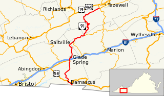
State Route 91 is a primary state highway in the U.S. state of Virginia. The state highway runs 55.12 miles (88.71 km) from the Tennessee state line near Damascus, where the highway continues as Tennessee State Route 91, north to U.S. Route 19 Business and US 460 Business at Frog Level. SR 91 connects Damascus in southeastern Washington County with the northeastern county town Glade Spring, where the highway has junctions with US 11 and Interstate 81 (I-81). The state highway also indirectly connects Saltville in northwestern Smyth County and Tazewell, the county seat of Tazewell County. SR 91 is the only primary state highway in Virginia with an unpaved section; this gravel section is in southern Tazewell County.
Ice Mountain is a mountain ridge and algific talus slope that is part of a 149-acre (60 ha) preserve near the community of North River Mills in Hampshire County, West Virginia, United States. It was designated a National Natural Landmark in 2012.

Old Main is a collection of five buildings joined together at central campus of Marshall University in Huntington, West Virginia. It is located at the junction of Hal Greer Boulevard and Fourth Avenue. The original structure was completed in 1868, with four other additions that was completed at various intervals until 1907. It is a landmark structure on campus, its towers becoming a "symbol of the university."
Eglon is an unincorporated community in Preston County, West Virginia, United States. Its elevation is 2,628 feet (801 m). It has a post office with the ZIP code 26716.

Spruce Mountain, in eastern West Virginia, USA, is the highest ridge of the Allegheny Mountains. The "whale-backed" ridge extends for only about 16 miles (26 km), from northeast to southwest, but several of its peaks exceed 4,500 feet (1,400 m) in elevation. The summit, Spruce Knob, is celebrated as the highest point in the state as well as the range, which covers parts of four states.
Maplewood is an unincorporated community in Fayette County, West Virginia, United States. Maplewood is located on West Virginia Route 41, 6.5 miles (10.5 km) northwest of Meadow Bridge.
Maple Acre is an unincorporated community in Mercer County, West Virginia, United States. Maple Acre is located near U.S. Route 19, 3.5 miles (5.6 km) south-southwest of Princeton.

The natural environment of Virginia encompasses the physical geography and biology of the U.S. state of Virginia. Virginia has a total area of 42,774.2 square miles (110,784.67 km2), including 3,180.13 square miles (8,236.5 km2) of water, making it the 35th-largest state by area. Forests cover 65% of the state, wetlands and water cover 6% of the land in the state, while 5% of the state is a mixture of commercial, residential, and transitional.
Maple View is an unincorporated community in Mercer County, West Virginia, United States. Maple View is 4 miles (6.4 km) northeast of Bluefield.
Maple Meadow is an unincorporated community in Raleigh County, West Virginia, United States.
Maple Fork is an unincorporated community in Raleigh County, West Virginia, United States.
Maple Run is an unincorporated community in Taylor County, West Virginia, United States.
Twin Sugars is a summit in West Virginia, in the United States. With an elevation of 3,602 feet (1,098 m), Twin Sugars is the 177th highest summit in the state of West Virginia.
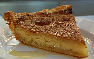
Maple custard pie is a custard pie from the cuisine of New England. Maple custard pies are sweetened only with maple sugar. Each year in New England maple sugar is made with the sap collected from local trees, a New England tradition dating to the 18th-century boycott of sugar imports from the West Indies. Because sugar from the West Indies was produced with slave labor, the maple pie is recognized as a symbol of New England's values of self-sufficiency and economic independence. The tradition of making maple pies continues into the present day but is not as common as it once was.


