Churchville, West Virginia | |
|---|---|
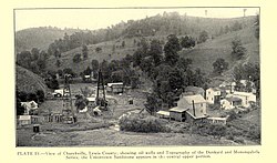 Churchville circa 1916 | |
 Churchville Location within the state of West Virginia  Churchville Churchville (the United States) | |
| Coordinates: 39°5′50″N80°35′29″W / 39.09722°N 80.59139°W | |
| Country | United States |
| State | West Virginia |
| County | Lewis |
| Elevation | 942 ft (287 m) |
| Time zone | UTC-5 (Eastern (EST)) |
| • Summer (DST) | UTC-4 (EDT) |
| GNIS ID | 1537340 [1] |
Churchville is an unincorporated community in Lewis County, West Virginia, United States.
Churchville was so named on account of the churches near the town site. [2]