Berlin, West Virginia

Last updated

Berlin, West Virginia
County reports and maps) BHL18235377.jpg
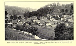
Berlin and Hackers Creek, 1916
USA West Virginia location map.svg
Red pog.svg
Berlin
Location within the state of West Virginia
Usa edcp location map.svg
Red pog.svg
Berlin
Berlin (the United States)
Coordinates: 39°3′9″N80°21′18″W / 39.05250°N 80.35500°W / 39.05250; -80.35500
Country United States
State West Virginia
County Lewis
Time zone UTC-5 (Eastern (EST))
  Summer (DST) UTC-4 (EDT)
GNIS feature ID1535657 [1]

Berlin is an unincorporated community in Lewis County, West Virginia, United States, along Hackers Creek. [2]

Related Research Articles

<span class="mw-page-title-main">Bluestone River</span> River in West Virginia, United States

The Bluestone River is a tributary of the New River, 77 mi (124 km) long, in southwestern Virginia and southern West Virginia in the United States. Via the New, Kanawha and Ohio rivers, it is part of the watershed of the Mississippi River. An 11 mi (18 km) portion of its lower course in West Virginia is designated as the Bluestone National Scenic River.

Aberdeen is an unincorporated community in Lewis County, West Virginia, United States, along Hackers Creek.

Elk Hills is an unincorporated community in central Kanawha County, West Virginia, United States. It lies on U.S. Route 119 along the Elk River, between the communities of Mink Shoals and Crede.

Davisville is an unincorporated community in Wood County, West Virginia, United States. Its elevation is 620 feet (189 m). It has a post office with the ZIP code 26142. The North Bend Rail Trail passes through the community.

Rock Castle is an unincorporated community in southwestern Jackson County, West Virginia, United States. It lies along Rock Castle Road, south of the city of Ripley, the county seat of Jackson County. Its elevation is 705 feet (215 m).

Murraysville is an unincorporated community in northern Jackson County, West Virginia, United States, along the Ohio River across from Long Bottom, Ohio. It lies along Murraysville Road, north of the city of Ripley, the county seat of Jackson County. Its elevation is 591 feet (180 m).

Mount Alto is an unincorporated community in far western Jackson County, West Virginia, United States. It lies along West Virginia Route 331, northwest of the city of Ripley, the county seat of Jackson County. Its elevation is 709 feet (216 m). Mount Alto had a post office, which closed on June 20, 2009.

Millwood is an unincorporated community in northwestern Jackson County, West Virginia, United States, along the Ohio River at the mouth of Mill Creek. It lies along West Virginia Routes 2 and 62 northwest of the city of Ripley, the county seat of Jackson County. Its elevation is 577 feet (176 m). Although Millwood is unincorporated, it has a post office, with the ZIP code of 25262.

LeRoy is an unincorporated community in northeastern Jackson County, West Virginia, United States. It lies along Liverpool Road between Reedy and Sandyville, northeast of the city of Ripley, the county seat of Jackson County. Its elevation is 646 feet (197 m). Although LeRoy is unincorporated, it has a post office, with the ZIP code of 25252.

Kentuck is an unincorporated community in southeastern Jackson County, West Virginia, United States. It lies along Kentuck Road southeast of the city of Ripley, the county seat of Jackson County. Its elevation is 922 feet (281 m).

Kenna is an unincorporated community in southern Jackson County, West Virginia, United States. It lies along West Virginia Route 34 just west of its interchange with Interstate 77, south of the city of Ripley, the county seat of Jackson County. Its elevation is 787 feet (240 m). Although Kenna is unincorporated, it has a post office, with the ZIP code of 25248.

Advent is an unincorporated community in southeastern Jackson County, West Virginia, United States. It lies along Advent Road southeast of the city of Ripley, the county seat of Jackson County, and near Jackson County's borders with Kanawha and Roane counties. Its elevation is 791 feet (241 m). Advent had a post office, which closed on December 25, 2010.

Given is an unincorporated community in southwestern Jackson County, West Virginia, United States. It lies at the intersection of Rock Castle, Shamblin Run, and Wolfe Creek Roads, south of the city of Ripley, the county seat of Jackson County. Its elevation is 689 feet (210 m). Although Given is unincorporated, it has a post office, with the ZIP code of 25245.

Flatwoods is an unincorporated community in northwestern Jackson County, West Virginia, United States. It lies at the intersection of Crooked Run and Harpold Roads, northwest of the city of Ripley, the county seat of Jackson County. Its elevation is 755 feet (230 m).

Sherman is an unincorporated community in northern Jackson County, West Virginia, United States, along the Ohio River. It lies along West Virginia Route 68 north of the city of Ravenswood. Its elevation is 600 feet (183 m).

<span class="mw-page-title-main">Left Hand, West Virginia</span> Unincorporated community in West Virginia, United States

Left Hand is an unincorporated community in southeastern Roane County, West Virginia, United States. It lies along West Virginia Route 36 southeast of the city of Spencer, the county seat of Roane County. Its post office is still active.

<span class="mw-page-title-main">Lashmeet, West Virginia</span> Census-designated place in West Virginia, United States

Lashmeet is a census-designated place (CDP) in western Mercer County, West Virginia, United States. It lies along West Virginia Route 10 northwest of the city of Princeton, the county seat of Mercer County. Its elevation is 2,539 feet (774 m). Although Lashmeet is unincorporated, it has a post office, with the ZIP code of 24733. As of the 2010 census, its population was 479.

Neola is an unincorporated community in northeastern Greenbrier County, West Virginia, United States. It lies along West Virginia Route 92 north of the city of White Sulphur Springs. Its elevation is 2,037 feet (621 m).

Hotchkiss is an unincorporated community in Raleigh County, West Virginia, United States, along the Slab Fork and West Virginia Route 54.

<span class="mw-page-title-main">Superior Bottom, West Virginia</span> Unincorporated community in West Virginia, United States

Superior Bottom is an unincorporated community in Logan County, West Virginia, United States. Superior Bottom is located along West Virginia Route 44 and Island Creek, 7 miles (11 km) south of Logan.

References

  1. U.S. Geological Survey Geographic Names Information System: Berlin, West Virginia
  2. DeLorme (1997). West Virginia Atlas & Gazetteer. Yarmouth, Maine: DeLorme. p.36. ISBN   0-89933-246-3.