Garrett County (gərɛt) is the westernmost county of the U.S. state of Maryland. As of the 2010 census, the population was 30,097, making it the third-least populous county in Maryland. Its county seat is Oakland. The county was named for John Work Garrett (1820–1884), president of the Baltimore and Ohio Railroad. Created from Allegany County, Maryland in 1872, it was the last Maryland county to be formed.

The Potomac River is located within the Mid-Atlantic region of the United States and flows from the Potomac Highlands into the Chesapeake Bay. The river is approximately 405 miles (652 km) long, with a drainage area of about 14,700 square miles (38,000 km2). In terms of area, this makes the Potomac River the fourth largest river along the Atlantic coast of the United States and the 21st largest in the United States. Over 5 million people live within the Potomac watershed.

The Au Sable River in Michigan, United States runs approximately 138 miles (222 km) through the northern Lower Peninsula, through the towns of Grayling and Mio, and enters Lake Huron at Au Sable. It is considered one of the best brown trout fisheries east of the Rockies and has been designated a blue ribbon trout stream by the Michigan Department of Natural Resources. In French, au sable literally means "at the sand." A 1795 map calls it the Beauais River.

The Feather River is the principal tributary of the Sacramento River, in the Sacramento Valley of Northern California. The river's main stem is about 73 miles (117 km) long. Its length to its most distant headwater tributary is just over 210 miles (340 km). The main stem Feather River begins in Lake Oroville, where its four long tributary forks join together—the South Fork, Middle Fork, North Fork, and West Branch Feather Rivers. These and other tributaries drain part of the northern Sierra Nevada, and the extreme southern Cascades, as well as a small portion of the Sacramento Valley. The total drainage basin is about 6,200 square miles (16,000 km2), with approximately 3,604 square miles (9,330 km2) above Lake Oroville.

The Patapsco River mainstem is a 39-mile-long (63 km) river in central Maryland which flows into the Chesapeake Bay. The river's tidal portion forms the harbor for the city of Baltimore. With its South Branch, the Patapsco forms the northern border of Howard County, Maryland. The name "Patapsco" is derived from the Algonquian pota-psk-ut, which translates to "backwater" or "tide covered with froth."

The Savage River is a 29.5-mile-long (47.5 km) river in Garrett County, Maryland, and is the first major tributary of the North Branch Potomac River from its source. The river was named for 18th century surveyor John Savage.

The Little Cacapon River is a 25.1-mile-long (40.4 km) free-flowing tributary of the Potomac River in the center of Hampshire County, West Virginia. Via the Potomac River, its waters are part of the Chesapeake Bay watershed, leading to the Atlantic Ocean. The Little Cacapon enters the Potomac at an elevation of 499 feet (152 m) near the community of Little Cacapon. For the majority of its course the Little Cacapon is a shallow non-navigable stream. It has been historically referred to as both Little Cacapehon and Little Capecaphon. The name is pronounced kə-KAY-pən or KAY-pən.

Big Run is a 4.4-mile-long (7.1 km) tributary stream of the South Branch Potomac River, belonging to the Potomac River and Chesapeake Bay watersheds. Big Run flows through the city of Romney and the campus of the West Virginia Schools for the Deaf and Blind in Hampshire County, West Virginia. The stream is known by local residents as Town Run and Town Creek.
Crooked Creek is a 26.3-mile-long (42.3 km) tributary of the Tioga River located entirely in Tioga County, Pennsylvania in the United States.

The Croton River is a river in southern New York with three principal tributaries: the West Branch, Middle Branch, and East Branch. Their waters, all part of the New York City water supply system, join downstream from the Croton Falls Reservoir. Together, their waters and the reservoirs linked to them represent the northern half of the New York City water system's Croton Watershed.

The West Branch Penobscot River is a 117-mile-long (188 km) tributary of the Penobscot River through the North Maine Woods in Maine. The river is also known as Abocadneticook, Kahgognamock, and Kettegwewick.
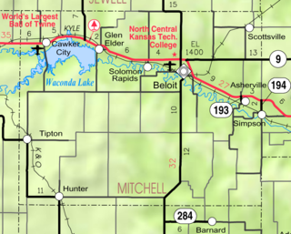
Waconda Lake, also known as Glen Elder Reservoir, is a reservoir in Mitchell County and Osborne County, Kansas, United States. Built and managed by the U.S. Bureau of Reclamation for flood control and irrigation, it is also used for recreation. Glen Elder State Park is located on its north shore.

Ruedi Reservoir is a reservoir on the West Slope of the Continental Divide on the Fryingpan River. It sits about 15 miles (24 km) upstream of the town of Basalt, Colorado, near Aspen. The reservoir is located within the White River National Forest, and straddles the county line between Pitkin County and Eagle County.

The Occoquan River is a tributary of the Potomac River in Northern Virginia, where it serves as part of the boundary between Fairfax and Prince William counties. The river is 24.7 miles (39.8 km) long, and its watershed covers about 590 square miles (1,528 km2). It is formed by the confluence of Broad Run and Cedar Run in Prince William County; Bull Run, which forms Prince William County's boundary with Loudoun and the northerly part of Fairfax counties, enters it east-southeast of Manassas, as the Occoquan turns to the southeast. It reaches the Potomac at Belmont Bay. The Occoquan River is part of the Chesapeake Bay watershed. The name Occoquan is derived from a Doeg Algonquian word translated as "at the end of the water".

Kirwin Reservoir is a reservoir in Phillips County, Kansas, United States. It is located next to the city of Kirwin in northern Kansas. The U.S. Bureau of Reclamation built it and continues to operate it for the purposes of flood control and area irrigation. The Kirwin National Wildlife Refuge lies on its shores.

Cheney Reservoir is a reservoir on the North Fork Ninnescah River in Reno, Kingman, and Sedgwick counties of Kansas in the United States. Built and managed by the U.S. Bureau of Reclamation for local water supply, it is also used for flood control and recreation. Cheney State Park is located on its shore.
Wolffs Run is a tributary of Stony Creek in Luzerne County, Pennsylvania. It is approximately 0.4 miles (0.64 km) long and flows through Hazle Township. The watershed of the stream has an area of 0.6 square miles (1.6 km2). A reservoir known as the Humboldt Reservoir is located on it. The reservoir serves as a water supply and is dammed by the Humboldt Dam.
Mercerville is an unincorporated community in Gallia County in southern Ohio, approximately seven miles (11 km) north of Crown City and 25 miles (40 km) northeast of Huntington, West Virginia, near the easternmost corner of Wayne National Forest and roughly five miles (8.0 km) west of the Ohio River, where Ohio borders West Virginia. Mercerville sits along State Route 218 (SR 218) near its intersection with SR 790. It is home to South Gallia High School, one of only three high schools in the entire county, and nearby Hannan Trace Elementary School.
The Potomac River basin reservoir projects were U.S. Army Corps of Engineers programs that sought to regulate the flow of the Potomac River to control flooding, to assure a reliable water supply for Washington, D.C., and to provide recreational opportunities. Beginning in 1921 the Corps studied a variety of proposals for an ambitious program of dam construction on the Potomac and its tributaries, which proposed as many as sixteen major dam and reservoir projects. The most ambitious proposals would have created a nearly continuous chain of reservoirs from tidewater to Cumberland, Maryland. The 1938 program was focused on flood control, on the heels of a major flood in 1936. The reformulated 1963 program focused on water supply and quality, mitigating upstream pollution from sewage and coal mine waste.

Little Stony Creek is a 6.8 mile long river in the George Washington and Jefferson National Forests in the Commonwealth of Virginia. It is a first-order tributary of the North Fork Shenandoah River and the Potomac River.