Seneca Creek (North Fork South Branch Potomac River)

Last updated
Seneca Creek
Seneca Creek - Mouth.jpg
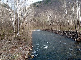
Seneca Creek just upstream of its mouth
Location
Country United States
State West Virginia
Counties Pendleton
Physical characteristics
SourceSlab Camp Run
 - locationAllegheny Mountain, Pendleton County, WV
 - coordinates 38°43′29″N79°33′23″W / 38.72472°N 79.55639°W / 38.72472; -79.55639
 - elevation3,912 ft (1,192 m) [1]
2nd sourceTrussel Run
 - locationSpruce Mountain, Pocahontas County, WV
 - coordinates 38°42′47″N79°32′31″W / 38.71306°N 79.54194°W / 38.71306; -79.54194
 - elevation3,944 ft (1,202 m) [2]
Source Confluence 
 - location Pendleton County, WV
 - coordinates 38°43′04″N79°32′46″W / 38.71778°N 79.54611°W / 38.71778; -79.54611
 - elevation3,747 ft (1,142 m) [3]
Mouth North Fork South Branch Potomac River [4]
 - location Seneca Rocks, WV
 - coordinates 38°09′42″N81°11′47″W / 38.16167°N 81.19639°W / 38.16167; -81.19639 Coordinates: 38°09′42″N81°11′47″W / 38.16167°N 81.19639°W / 38.16167; -81.19639
 - elevation1,532 ft (467 m)

Seneca Creek is a 19.6-mile-long (31.5 km) [5] tributary of the North Fork of the South Branch of the Potomac River located entirely within Pendleton County, West Virginia, USA.

Tributary stream or river that flows into a main stem river or lake

A tributary or affluent is a stream or river that flows into a larger stream or main stem river or a lake. A tributary does not flow directly into a sea or ocean. Tributaries and the main stem river drain the surrounding drainage basin of its surface water and groundwater, leading the water out into an ocean.

Pendleton County, West Virginia county in West Virginia, United States

Pendleton County is a county located in the U.S. state of West Virginia. As of the 2010 census, the population was 7,695, making it the fifth-least populous county in West Virginia. Its county seat is Franklin. The county was created by the Virginia General Assembly in 1788 from parts of Augusta, Hardy, and Rockingham Counties and was named for Edmund Pendleton (1721–1803), a distinguished Virginia statesman and jurist. Pendleton County was strongly pro-Confederate during the American Civil War; however, there were pockets of Union support.

West Virginia State of the United States of America

West Virginia is a state located in the Appalachian region in the Southern United States and is also considered to be a part of the Middle Atlantic States. It is bordered by Pennsylvania to the north, Maryland to the east and northeast, Virginia to the southeast, Kentucky to the southwest, and Ohio to the northwest. West Virginia is the 41st largest state by area, and is ranked 38th in population. The capital and largest city is Charleston.

Contents

Seneca Creek lies within the Appalachian Mountains, in the Spruce Knob-Seneca Rocks National Recreation Area of the Monongahela National Forest. It is formed by two spring-fed streams, Slab Camp Run and Trussel Run, on the western flanks of Spruce Mountain to the north of Spruce Knob. It empties into the North Fork of the South Branch at the community of Seneca Rocks near the base of the Seneca Rocks sandstone cliff formation.

Appalachian Mountains mountain range in the eastern United States and Canada

The Appalachian Mountains, often called the Appalachians, are a system of mountains in eastern North America. The Appalachians first formed roughly 480 million years ago during the Ordovician Period. They once reached elevations similar to those of the Alps and the Rocky Mountains before experiencing natural erosion. The Appalachian chain is a barrier to east–west travel, as it forms a series of alternating ridgelines and valleys oriented in opposition to most highways and railroads running east–west.

Spruce Knob-Seneca Rocks National Recreation Area

Spruce Knob-Seneca Rocks National Recreation Area is a U.S. National Recreation Area (NRA) located within the Monongahela National Forest of eastern West Virginia, USA.

Monongahela National Forest

The Monongahela National Forest is a national forest located in the Allegheny Mountains of eastern West Virginia, USA. It protects over 921,000 acres of federally owned land within a 1,700,000 acres proclamation boundary that includes much of the Potomac Highlands Region and portions of 10 counties.

Recreation

Seneca Creek is popular destination for anglers, hikers, and backpackers. In 1999 it was named one of the 100 best trout streams in the United States. [6] It holds native brook trout from the northern strain as well as wild rainbow trout. [7]

The upper portion of the creek is paralleled by the Seneca Creek Trail, a 5-mile trail that begins at the Eastern Continental Divide on National Forest Road 112 and ends at its junction with the Horton Trail. The trail is part of the Seneca Creek Backcountry trail system, a 60-mile network of trails that extends from the Eastern Continental Divide down into the towns of Whitmer and Onego and is bounded by Gandy Creek to the west and Spruce Mountain to the east. [8]

Eastern Continental Divide Hydrological divide in eastern North America

The Eastern Continental Divide or Eastern Divide or Appalachian Divide is a hydrographic divide in eastern North America that separates the easterly Atlantic Seaboard watershed from the westerly Gulf of Mexico watershed. The divide nearly spans the United States from south of Lake Ontario through the Florida peninsula, and consists of raised terrain including the Appalachian Mountains to the north, the southern Piedmont Plateau and lowland ridges in the Atlantic Coastal Plain to the south. Water including rainfall and snowfall, lakes, streams and rivers on the eastern/southern side of the divide drains to the Atlantic Ocean; water on the western/northern side of the divide drains to the Gulf of Mexico. The ECD is one of six continental hydrographic divides of North America which define several drainage basins, each of which drains to a particular body of water.

Spruce Mountain (West Virginia)

Spruce Mountain, in eastern West Virginia, USA, is the highest ridge of the Allegheny Mountains. The "whale-backed" ridge extends for only about 16 miles (26 km), from northeast to southwest, but several of its peaks exceed 4,500 feet (1,400 m) in elevation. The summit, Spruce Knob, is celebrated as the highest point in the state as well as the range, which covers parts of four states.

Tributaries

Tributary streams are listed from south (source) to north (mouth).

Communities along Seneca Creek

See also

Related Research Articles

Allegheny Front

The Allegheny Front is the major southeast- or east-facing escarpment in the Allegheny Mountains in southern Pennsylvania, western Maryland, and eastern West Virginia, USA. The Allegheny Front forms the boundary between the Ridge-and-Valley Appalachians to its east and the Appalachian Plateau to its west. The Front is closely associated with the Appalachian Mountains' Eastern Continental Divide, which in this area divides the waters of the Ohio/Mississippi river system, flowing to the Gulf of Mexico, from rivers flowing into Chesapeake Bay and from there into the Atlantic Ocean.

Dolly Sods Wilderness

The Dolly Sods Wilderness — originally simply Dolly Sods — is a U.S. Wilderness Area in the Allegheny Mountains of eastern West Virginia, USA, and is part of the Monongahela National Forest (MNF) of the U.S. Forest Service (USFS).

Seneca Rocks

Seneca Rocks is a large crag and local landmark in Pendleton County in the Eastern Panhandle of West Virginia, USA. The south peak is one of a small number of peaks inaccessible except by technical rock climbing techniques on the East Coast of the United States. One of the best-known scenic attractions in West Virginia, the sheer rock faces are a popular challenge for rock climbers.

The Potomac Highlands of West Virginia centers on five West Virginian counties in the upper Potomac River watershed in the western portion of the state's Eastern Panhandle, bordering Maryland and Virginia. Because of geographical proximity, similar topography and landscapes, and shared culture and history, the Potomac Highlands region also includes Pocahontas, Randolph, and Tucker counties, even though they are in the Monongahela River or New River watersheds and not that of the Potomac River.

Onego, West Virginia Unincorporated community in West Virginia, United States

Onego is an unincorporated community located along U.S. Highway 33 at the confluence of Seneca Creek and Roaring Creek in Pendleton County, West Virginia, United States. Onego lies within the Monongahela National Forest in the Appalachian Mountains, near Seneca Rocks.

Cabins, West Virginia Unincorporated community in West Virginia, United States

Cabins is an unincorporated community on the North Fork South Branch Potomac River in Grant County, West Virginia, United States. Cabins lies within the Spruce Knob-Seneca Rocks National Recreation Area of the Monongahela National Forest.

Hopeville, West Virginia Unincorporated community in West Virginia, United States

Hopeville is an unincorporated community on the North Fork South Branch Potomac River in Grant County, West Virginia, United States. Hopeville lies within the Spruce Knob-Seneca Rocks National Recreation Area of the Monongahela National Forest. It formerly had its own school and post office in operation until the middle of the 20th century.

Seneca Rocks, West Virginia Unincorporated community in West Virginia, United States

Seneca Rocks is an unincorporated community located in Pendleton County, West Virginia, United States. The community of Seneca Rocks — formerly known as Mouth of Seneca — lies at the junction of US 33, WV 28 and WV 55 near the confluence of Seneca Creek and the North Fork South Branch Potomac River. The community also lies near Seneca Rocks, the crag from which it takes its name. Both lie within the Spruce Knob-Seneca Rocks National Recreation Area of the Monongahela National Forest.

North Fork Mountain mountain in United States of America

North Fork Mountain is a quartzite-capped mountain ridge in the Ridge and Valley physiographic province of the Allegheny Mountains of eastern West Virginia, USA. Kile Knob, at 4,588 feet, is the mountain's highest point, and Panther Knob and Pike Knob are nearly as high.

Tuscarora Sandstone

The Silurian Tuscarora Formation — also known as Tuscarora Sandstone or Tuscarora Quartzite — is a mapped bedrock unit in Pennsylvania, Maryland, West Virginia, and Virginia, USA.

Shavers Mountain

Shavers Mountain, is a high and rugged ridge situated in the Allegheny Mountains of eastern West Virginia. It is about 35 miles (56 km) long, north to south, and several of its peaks exceed 4,000 feet (1,200 m) in elevation. Shavers Mountain is notable for being "bookended", at its northern and southern ends, by two exceptional natural areas: the Otter Creek Wilderness and the Gaudineer Scenic Area, respectively, both of which preserve small stands of old growth forest on the mountain.

Otter Creek Wilderness

The Otter Creek Wilderness is a U.S. Wilderness area located in the Cheat-Potomac Ranger District of Monongahela National Forest in West Virginia, USA. The Wilderness sits in a bowl-shaped valley formed by Otter Creek, between McGowan Mountain and Shavers Mountain in Tucker and Randolph Counties. It is crossed by 42 miles (68 km) of hiking trails. Otter Creek Trail is the longest, at 11 miles (18 km).

U.S. Route 33 in West Virginia highway in West Virginia

In the U.S. state of West Virginia, US 33 extends 248 miles (399 km) from the Ohio River at Ravenswood to the Virginia state line atop Shenandoah Mountain west of Harrisonburg, Virginia.

Judy Gap, West Virginia Unincorporated community in West Virginia, United States

Judy Gap is an unincorporated community in Pendleton County, West Virginia, United States. Judy Gap is located at the junction of U.S. Route 33 and West Virginia Route 28 8.5 miles (13.7 km) west-northwest of Franklin, just west of the mountain gap also called Judy Gap. The Judy Rocks geological formation is just to the south. North Fork Mountain is to the east, and the North Fork of the South Branch of the Potomac River is to the west, with Spruce Mountain and Spruce Knob beyond the river. Most of the surrounding land is within the Monongahela National Forest.

Laurel Fork (North Fork South Branch Potomac River tributary)

The Laurel Fork is a 15.7-mile-long (25.3 km) stream in Virginia and West Virginia, United States. The stream flows north from Highland County, Virginia, where its source and the majority of its length is located, to its mouth in Pendleton County, West Virginia. Laurel Fork is a tributary to the North Fork South Branch Potomac River, making it a part of the Potomac River watershed. The area surrounding Laurel Fork is home to several plant and animal species found nowhere else in Virginia, and is a prime example of a northern boreal forest in the state.

Big Run (North Fork South Branch Potomac River tributary)

Big Run is a river of 13 miles in length, located one-and-a-half miles west of Spruce Knob in Monongahela National Forest, in Pendleton County, West Virginia. It is a tributary of the North Fork South Branch Potomac River.

References

  1. "Slab Camp Run Source". Elevation Query. U.S. Geological Survey . Retrieved 2008-09-13.
  2. "Trussel Run Source". Elevation Query. U.S. Geological Survey . Retrieved 2008-09-13.
  3. "Trussel Run". Geographic Names Information System . United States Geological Survey. 1980-06-27. Retrieved 2008-09-13.
  4. "Seneca Creek". Geographic Names Information System . United States Geological Survey. 1980-06-27. Retrieved 2008-09-13.
  5. U.S. Geological Survey. National Hydrography Dataset high-resolution flowline data. The National Map, accessed August 15, 2011
  6. Ross, John (1999). America's 100 Best Trout Streams (3 ed.). Lyons Press. ISBN   0762780312.
  7. Slar, JMA. "Seneca Creek West Virginia". Trout Pro. Retrieved 14 July 2016.
  8. deHart, Allen; Sundquist, Bruce (1999). Monongahela National Forest Hiking Guide. West Virginia Highlands Conservancy. ISBN   0961655321.

Commons-logo.svg Media related to Seneca Creek Trail at Wikimedia Commons