Highland, Maryland | |
---|---|
Coordinates: 39°10′44.7″N76°57′27.7″W / 39.179083°N 76.957694°W | |
Country | United States of America |
State | Maryland |
County | Howard |
Area | |
• Total | 2.42 sq mi (6.27 km2) |
• Land | 2.41 sq mi (6.23 km2) |
• Water | 0.01 sq mi (0.04 km2) |
Elevation | 520 ft (160 m) |
Population (2020) | |
• Total | 1,133 |
• Density | 470.91/sq mi (181.80/km2) |
Time zone | UTC-5 (EST) |
• Summer (DST) | UTC-4 (EDT) |
ZIP Code | 20777 |
Area codes | 301, 240 |
FIPS code | 24-38475 |
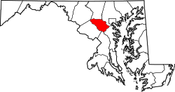
Highland is an unincorporated community and census-designated place in Howard County, Maryland, United States. As of the 2020 census it had a population of 1,133. [2] It uses the 20777 zip code.
The community is located in southern Howard County at the junction of Highland Road, Maryland Route 216 and Maryland Route 108, and is still heavily influenced by its agrarian history; farms and horse fields are common in the area. The crossroads itself has a small-town feel, with various shops including some that share in the town history. Clarksville is 2 miles (3 km) to the north on MD 108, Laurel is 9 miles (14 km) to the southeast on MD 216, and Olney is 7 miles (11 km) to the west on MD 108. The center of Columbia is 8 miles (13 km) to the northeast.
Census | Pop. | Note | %± |
---|---|---|---|
2010 | 1,034 | — | |
2020 | 1,133 | 9.6% | |
U.S. Decennial Census [2] |
As a rural crossroads, many of its community members took it upon themselves to maintain the historical sites and feel of the hamlet by founding the Greater Highland Crossroads Association (GHCA) in 2002. [3] In 2014, the Crossroads were placed on the Preserve Howard top ten most endangered list due to current DPZ plans. [4] They are marked by four signs.
The majority of the downtown Highland district is situated within the 418-acre (169 ha) land grant named "Hickory Ridge". The Rouse Company borrowed the land grant name for one of its nearby villages of Columbia, built in 1974. The historic "White Hall" or "Hickory Ridge" estate (1749) was owned by the Ridgely, Hopkins and Disney families. [5] One of the earliest businesses at the crossroads was Well's tavern, founded by Richard Wells in 1759. This was replaced with a wheelwright's shop by Joshua B. Disney in 1842. The same year, William Wall opened a general store and post office, giving the crossroads the short-lived name of "Walls Crossroads" before another name change of the post office on December 2, 1878, to "Highland" to reflect the town's elevation in Howard County. [6] [7] [8] The County Commissioners added Hall Shop Road on the southern side of the community in 1877. [9] The town did not receive direct rail service, but was only nine miles away from the B&O railroad in Laurel, Maryland using the rolling road now known as Route 216. [10]
A literary club formed in Highland in the late 19th century; J. B. Warfield in describing the Highland of 1904 refers to it as the "literary center of the county". [11] [12]
Highland played several important roles in U.S. history. The town housed meetings that affected the events of the Boston Tea Party.[ citation needed ] Well's Tavern (now the Kitty Bed and Breakfast) was the primary meeting place of a group of Northern sympathizers in the Civil War.
The Virginia Hardy Boarding School provided classes for students during the turn of the century. [13]
In 2015, the group Preservation Howard County placed the crossroads on its top 10 most endangered site list. [14]
Columbia is a census-designated place in Howard County, Maryland, United States. It is a planned community consisting of 10 self-contained villages. The census-designated place had a population of 104,681 at the 2020 census, making it the second most populous community in Maryland after Baltimore. Columbia, located between Baltimore and Washington, D.C., is officially part of the Baltimore metropolitan area.
North Laurel is a census-designated place (CDP) in Howard County, Maryland, United States. The published population was 4,474 at the 2010 census. This population was substantially less than the CDP's population in 2000, and was the result of an error in defining the boundary prior to tabulation and publication of 2010 Census results. The corrected 2010 Census population is 20,259. North Laurel is adjacent to the City of Laurel, which is located across the Patuxent River in Prince George's County.
Laurel is a city in Maryland, United States, located midway between Washington, D.C. and Baltimore on the banks of the Patuxent River. While the city limits are entirely in northern Prince George's County, outlying developments extend into Anne Arundel, Montgomery and Howard counties. Founded as a mill town in the early 19th century, Laurel expanded local industry and was later able to become an early commuter town for Washington and Baltimore workers following the arrival of the Baltimore and Ohio Railroad in 1835. Largely residential today, the city maintains a historic district centered on its Main Street, highlighting its industrial past.
Jessup is an unincorporated community and census-designated place in Howard and Anne Arundel counties, about 15 miles (24 km) southwest of Baltimore, Maryland, United States. Per the 2020 census, the population was 10,535.
Savage is an unincorporated community and census-designated place located in Howard County, Maryland, United States, approximately 18 miles (29 km) south of Baltimore and 21 miles (34 km) north of Washington, D.C. It is situated close to the city of Laurel and to the planned community of Columbia. As of the 2020 census, it had a population of 7,542. The former mill town is a registered historic place, and has several original buildings preserved within and around the Savage Mill Historic District.
Hickory Ridge is one of the 10 villages in Columbia, Maryland, United States, located to the west of the Town Center with a 2014 population of 13,000 in 4,659 housing units. The village overlays the former postal community of Elioak. It was first occupied in 1974. Neighborhoods in the village are Hawthorn, Clary's Forest, and Clemens Crossing. The name Hickory Ridge is derived from the 1749 estate "Hickory Ridge" in nearby Highland, which later became the family home of the nephew of hospital and university founder Johns Hopkins.
Maryland Route 108 is a state highway in the U.S. state of Maryland. The highway runs 34.23 miles (55.09 km) from MD 27 in Damascus east to MD 175 in Columbia. MD 108 is an S-shaped highway that winds through northern Montgomery County and central Howard County. The highway connects the Montgomery County communities of Laytonsville, Olney, Sandy Spring, and Ashton with the Howard County villages of Highland and Clarksville. MD 108 serves as the northern edge of Columbia and connects several of the planned community's suburban villages.
Lisbon is a census-designated place located in western Howard County in the state of Maryland, United States, located roughly between Baltimore and Frederick and north of Washington, D.C. It is contained in an area of roughly one square mile. Lisbon is located along Interstate 70 and Maryland Route 144 and is home to the first roundabout in Maryland. It first appeared as a CDP in the 2020 Census with a population of 282.
West Friendship is a semi-rural unincorporated community in western Howard County, Maryland, United States. West Friendship is located at the junction of Interstate 70 and Maryland Route 32. Frederick Road is a main thoroughfare.
Maryland Route 216 is a state highway in the U.S. state of Maryland. Known for most of its length as Scaggsville Road, the highway runs 8.73 miles (14.05 km) from MD 108 at Highland east to MD 198 in Laurel. MD 216 connects Highland, Fulton, Scaggsville, and North Laurel in southern Howard County with Laurel in far northern Prince George's County. The highway connects those communities with Interstate 95 (I-95) and U.S. Route 29.
Scaggsville is an unincorporated community and census-designated place in Howard County, Maryland, United States. It is situated near the southeastern tip of Howard County, between Laurel and Fulton. As of the 2010 census it had a population of 24,333. The town mainly consists of residences, with some commercial establishments. Scaggsville generally falls within ZIP code 20723, assigned to Laurel, though the town formerly had its own post office.
Ilchester is an unincorporated community and census-designated place in Howard County, Maryland, United States. The population was 23,476 at the 2010 census. It was named after the village of Ilchester in the English county of Somerset.
Paternal Gift Farm is an historic farm converted to an unincorporated community located in Howard County, Maryland, United States in the Highland, Maryland ZIP code of 20777. The Paternal Gift Farm, Inc is its homeowners' association, and all homeowners are members.
Dayton is an unincorporated community located in Howard County, Maryland, United States.
Fulton is a census-designated place located in southern Howard County, Maryland, United States. As of the 2010 census it had a population of 2,049.
Whiskey Bottom Road is a historic road north of Laurel, Maryland that traverses Anne Arundel and Howard Counties in an area that was first settled by English colonists in the mid-1600s. The road was named in the 1880s in association with one of its residents delivering whiskey after a prohibition vote. With increased residential development after World War II, it was designated a collector road in the 1960s; a community center and park are among the most recent roadside developments.
Maryland Route 983 was the unsigned designation for a pair of state highways in the U.S. state of Maryland. The highways formed parts of the old alignment of MD 216 on either side of Interstate 95 (I-95) in North Laurel in southeastern Howard County. MD 983 had a length of 1.02 miles (1.64 km) and ran on the east side of I-95. MD 983A spanned 0.71 miles (1.14 km) on the west side of I-95. MD 216 through North Laurel was built in the early 1920s. The segments of MD 983 were designated when MD 216 was relocated east of I-95 in the early 1960s and west of I-95 in the late 1970s. In 2017, both MD 983 and MD 983A were removed from the state highway system and transferred to county maintenance.
Daisy is an unincorporated community located at the northwest tip of Howard County, Maryland, United States.
Hickory Ridge or White Hall is an historic property located in Highland in Howard County, Maryland, United States. It is registered in the Maryland Inventory of Historic Properties.