Guilford, Maryland

Last updated

Guilford, Maryland
Christ Church Guilford Sept 09.JPG
Christ Church of Guilford, rebuilt in 1809
USA Maryland location map.svg
Red pog.svg
Guilford
Usa edcp location map.svg
Red pog.svg
Guilford
Coordinates: 39°10′11″N76°49′51″W / 39.16972°N 76.83083°W / 39.16972; -76.83083
Country United States
State Maryland
County Howard
CDPs Jessup, Columbia
EstablishedDecember 31, 1874
Named for Guilford Factory
Government
  Councilman Calvin Ball III [1]
District 2
Time zone UTC-5 (Eastern)
  Summer (DST) UTC-4 (EDT)
ZIP code
20794, 21046
Area code 410, 443, and 667

Guilford is an unincorporated community located in Howard County in the state of Maryland. [2] The location is named after the Guilford Mill. Guilford is near Kings Contrivance, one of the nine "villages" of Columbia.

Contents

For United States Census Bureau statistics, Guilford is split between the census-designated places of Savage and Columbia.

History

The area around Guilford was settled before it was called by the name of its mill. In 1711, the Log Chapel of Ease, now called Christ Church Guilford, was founded to the north of Guilford on a piece of land surveyed as "New Year's Gift" by Charles Carroll of Carrollton. The first full-time rector was James Magill, who lived at Athol. [3] The church was listed on the National Register of Historic Places in 1978. [4]

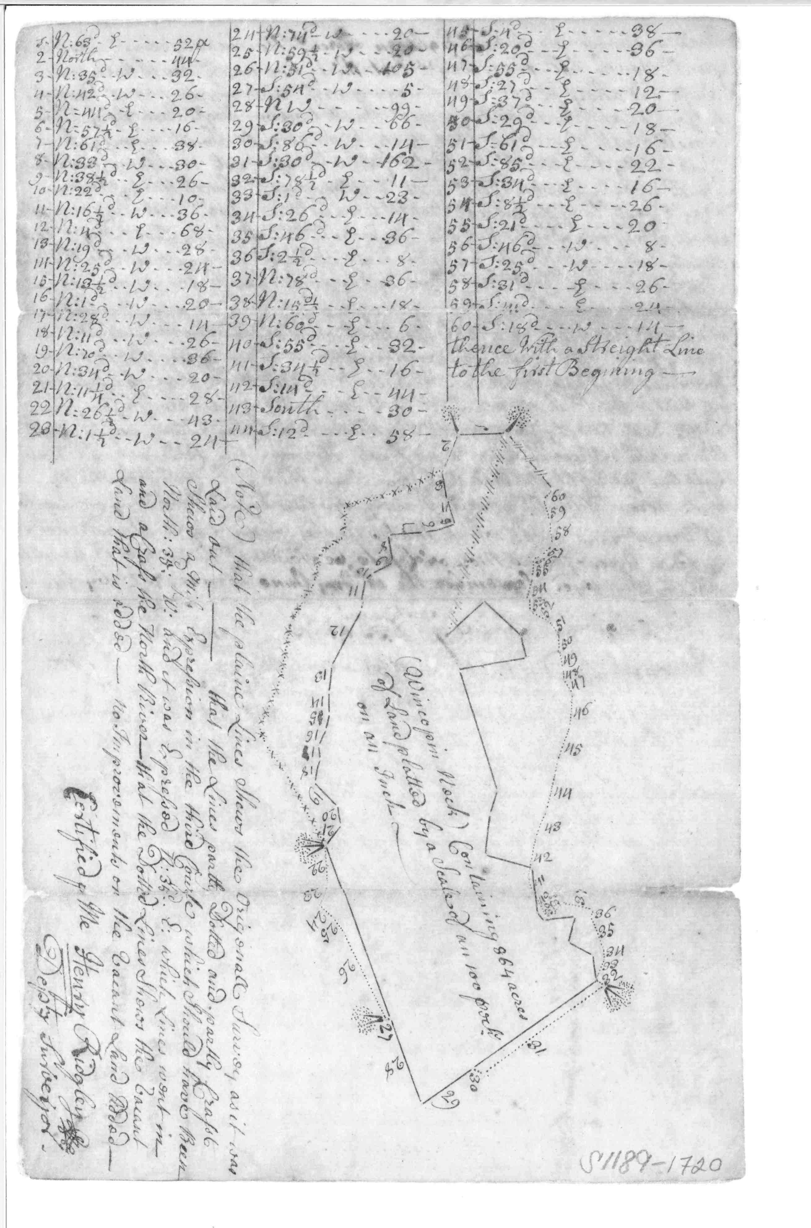
Guilford Mill (later called Gary Mill) was situated on the northern branch of the Patuxent River, known as the Little Patuxent River. The mill may have been in operation as early as 1743, and one is documented to have been in operation by 1761 when the area was still part of Northwestern Anne Arundell County. Charles Alexander Warfield and Elizabeth Ridgley built a joint mill on land patented as "Wincopin Neck". Gristmill operations were underway by 1760. [5] [6] Later owners of the factory included Richard Ridgley. [7] By 1792 the site consisted of a gristmill, sawmill, blacksmith and a stable. By 1881 the mill was managed by James S Gary and Son producing cotton with 50 looms. On August 15, 1890 a fire destroyed the mill collapsing the stone walls of the three and a half story tall building. [8]

Around 1834, a granite quarry was started, quarrying what is now known as the Guilford Quartz Monzonite. Just north of the quarry, Charles Worthington built a stone home with walls two feet thick named "Moundview" that would stand until 1990 when the South Columbia Baptist Church was built on its site. [9] [10] [11] By 1860, Henry A. Penny built a house onsite in 1860 and worked as a hauler. He would become county commissioner in the early 1900s. From 1863 to 1890, when slave labor was unavailable, the quarries were mostly stagnant.

On December 31, 1874 the Guilford Post office opened and remained in operation until June 30, 1920. [12] In 1876, Guilford School opens on Guilford and Oakland Mills roads, and Guilford Colored School opens on land given by Williams, Clark and Rodgers near Guilford and Mission roads. [13]

As the quarry started production again, it was known as one of the best paying jobs for African American laborers, who were not allowed to work in the nearby town of Savage. Many laborers from out of town would stay in a hotel for workers and get supplies from the company store. [14] In 1901, the Maryland Granite Company purchased the quarry, followed by spur line construction between Savage and Guilford in 1902. The steel Pratt truss bridge crossing the Little Patuxent built that year remains onsite today. By 1905 Guilford Road was macadamized with loads being pulled by six-horse teams. During this time, the quarry was now operated by the Granite Company of Baltimore. A community with two churches and two dozen buildings was formed around the present Guilford and Oakland Mills road intersections. [15]

The First Baptist Church of Guilford was formed by Reverend Willis Carter in a tenant house and has since grown to its fourth new building. [16]

By 1908 the large quarry was 100 feet deep producing monument stone and building stone. The smaller quarry to the southeast owned by the Guilford and Watersville Granite company operated from 1887 to 1893. [17] The town joint mill ran as a cotton factory that operated from 1895 to 1916. [18]

By 1908 operations ceased at the Guilford Granite and Stone Company Quarry on the western river bank, and the Penny Quarry, which was later filled in for an office complex. [19] In February 1928 the B&O discontinued its Patuxent rail spur service downstream to Savage, Maryland. [20]

In 1954 the 11 room Guilford Colored School was built, and remains in operation as Howard County's oldest formerly segregated school. [13]

From 1963 to 1966, the Rouse Company worked with family members of the County Commissioner to purchase 14,000 acres of Howard County farms using multiple shell companies. The properties around Guilford were bought by Howard Research and Development and 95-32LLC. [15]

Present Guilford

In a 1900s accounting of the Guilford Factory site, author Joshua Dorsey Warfeild accounts of "enduring stone homes made of Granite found there, they will stand for centuries". [5] A 1978 survey of the property performed prior to additional development stated that the buildings were in use until the 1950s, but were "demolished long ago" without explanation. [15] A 2004 survey conducted by the construction firm KCI Technologies contained few specific details of the removal of the historic structures, but concluded that 20 years of continued development "Guilford industrial complex has been extensively compromised by new construction, and, therefore, lacks the integrity required for listing in the National Register" [21]

Modern Guilford Road spans from southeastern Columbia, through Savage and Annapolis Junction to Fort Meade. The road is bisected by modern route 29, 32, I-95, and 295, leaving a mix of historical original road and newly aligned roads. The road crosses between the most heavily populated sections of the county, reminding residents of a place that is still there, but claimed as part of Savage and marketed as Columbia. The towns of Simpsonville (Columbia), Waterloo (Jessup), Magnolia (Jessup), and Pierceland (Annapolis Junction) have been taken over by their larger counterparts as well.

Of the three large remaining farms that occupied Wincopian Neck, Overlook Farm and Fairlands remain well preserved, but the 124 acre Ponsettia producing Wincopia Farms was purchased for development after Gourley and Gourley LLC foreclosed on a $3 million high interest sustainment loan reselling the property for $41 million to build 220 homes on the site. [22] [23]

Education

The Guilford area currently is home to one public school, Guilford Elementary School on Oakland Mills Road in Columbia. Future plans call for a new elementary school to be built on land adjacent to the Savage Stone Quarry in between Washington Boulevard and Mission Road. [24] In 2023, the new Guilford Park High School opened on the land adjacent to the Savage Stone Quarry.

See also

Related Research Articles

<span class="mw-page-title-main">Ellicott City, Maryland</span> Census-designated place in Maryland, United States

Ellicott City is an unincorporated community and census-designated place in, and the county seat of, Howard County, Maryland, United States. Part of the Baltimore metropolitan area, its population was 75,947 at the 2020 census, making it the most populous unincorporated county seat in the country.

<span class="mw-page-title-main">North Laurel, Maryland</span> Census-designated place in Maryland

North Laurel is a census-designated place (CDP) in Howard County, Maryland, United States. The published population was 4,474 at the 2010 census. This population was substantially less than the CDP's population in 2000, and was the result of an error in defining the boundary prior to tabulation and publication of 2010 Census results. The corrected 2010 Census population is 20,259. North Laurel is adjacent to the City of Laurel, which is located across the Patuxent River in Prince George's County.

<span class="mw-page-title-main">Jessup, Maryland</span> Census-designated place in Maryland

Jessup is an unincorporated community and census-designated place in Howard and Anne Arundel counties, about 15 miles (24 km) southwest of Baltimore, Maryland, United States. Per the 2020 census, the population was 10,535.

<span class="mw-page-title-main">Clarksville, Maryland</span> Unincorporated community in Maryland

Clarksville is an unincorporated community in Howard County, Maryland; the second highest-earning county in the United States according to the U.S. Census Bureau. The community is named for William Clark, a farmer who owned much of the land on which the community now lies and served as a postal stop that opened on the 4th of July 1851.

<span class="mw-page-title-main">Savage, Maryland</span> Census-designated place in Maryland, United States

Savage is an unincorporated community and census-designated place located in Howard County, Maryland, United States, approximately 18 miles (29 km) south of Baltimore and 21 miles (34 km) north of Washington, D.C. It is situated close to the city of Laurel and to the planned community of Columbia. As of the 2020 census, it had a population of 7,542. The former mill town is a registered historic place, and has several original buildings preserved within and around the Savage Mill Historic District.

<span class="mw-page-title-main">Kings Contrivance, Columbia, Maryland</span> Village in Maryland, United States

Kings Contrivance is a village in the planned community of Columbia, Maryland, United States and is home to approximately 11,000 residents. It is Columbia's southernmost village, and was the eighth of Columbia's ten villages to be developed. Kings Contrivance consists of the neighborhoods of Macgill's Common, Huntington and Dickinson, and includes single-family homes, townhouses, apartments and a Village Center.

The Howard County Public School System (HCPSS) is the school district that manages and runs the public schools of Howard County, Maryland. It operates under the supervision of an elected, eight-member Board of Education. Antonia Watts is the chair of the board. Michael J. Martirano has served as the superintendent since May 2017.

<span class="mw-page-title-main">Savage Mill</span> United States historic place

The Savage Mill is a historic cotton mill complex in Savage, Maryland, which has been turned into a complex of shops and restaurants. It was placed on the National Register of Historic Places in 1974. It is located in the Savage Mill Historic District. Buildings in the complex date from 1822 to 1916.

<span class="mw-page-title-main">Savage Mill Historic District</span> Historic district in Maryland, United States

The Savage Mill Historic District is a national historic district located at Savage, Howard County, Maryland. The district comprises the industrial complex of Savage Mill and the village of workers' housing to the north of the complex.

Simpsonville is an unincorporated community in Howard County, Maryland, United States.

<span class="mw-page-title-main">Whiskey Bottom Road</span> Historic road north of Laurel, Maryland, U.S.

Whiskey Bottom Road is a historic road north of Laurel, Maryland that traverses Anne Arundel and Howard Counties in an area that was first settled by English colonists in the mid-1600s. The road was named in the 1880s in association with one of its residents delivering whiskey after a prohibition vote. With increased residential development after World War II, it was designated a collector road in the 1960s; a community center and park are among the most recent roadside developments.

<span class="mw-page-title-main">Guilford Quartz Monzonite</span> Quartz monzonite pluton in Howard County, Maryland

The Guilford Quartz Monzonite is a Silurian or Ordovician quartz monzonite pluton in Howard County, Maryland. It is described as a biotite-muscovite-quartz monzonite which occurs as discontinuous lenticular bodies which intrude mainly through the Wissahickon Formation (gneiss).

Welling's Stone House or Clifton is a historic stone house situated between Clarksville, Maryland and Fulton, Maryland.

<span class="mw-page-title-main">Oakland Manor</span> Historic house in Maryland, United States

Oakland or Oakland Manor is a Federal style stone manor house commissioned in 1810 by Charles Sterrett Ridgely in the Howard District of Anne Arundel County, Maryland. The lands that became Oakland Manor were patented by John Dorsey as "Dorsey's Adventure" in 1688 which was willed to his grandson Edward Dorsey. In 1785, Luther Martin purchased properties named "Dorsey's Adventure", "Dorsey's Inheritance", "Good for Little", "Chew's Vineyard", and "Adam the First" to make the 2300 acre "Luther Martin's Elkridge Farm".

<span class="mw-page-title-main">Simpsonville Mill</span> Grist Mill in Columbia, Maryland

The Simpsonville Mill is a historic pre-colonial mill complex in Simpsonville, Maryland, part of the Columbia, Maryland land development.

Moundland was a historic plantation home located between Simpsonville and Guilford, Howard County, Maryland, now part of the Columbia land development.

Paul Griffith ("Pete") Stromberg was the owner since 1940 and editor since 1920 of "The Howard County Times", founded 1840 in Ellicott City, Maryland, the county seat of Howard County, which later grew into a syndicate of local community newspapers known as the "Stromberg Newspapers" in Howard County, Anne Arundel County, Prince George's County, Baltimore County and Baltimore City. He also was a Maryland State Senator from Howard County in the General Assembly of Maryland.

<span class="mw-page-title-main">Guilford Road</span>

Guilford Road is a historic road north of Savage, Maryland that traverses Anne Arundel and Howard Counties in an area that was first settled by English colonists in the mid-1600s. Today's Guilford road is a series of disconnected segments bisected multiple times by the construction of Maryland Route 32.

<span class="mw-page-title-main">Guilford Quarry Pratt Through Truss Bridge</span> Bridge in Guilford, Maryland

The Guilford Quarry Pratt Through Truss Bridge at Guilford, Maryland is a single-span, metal truss, railroad bridge

References

  1. "Howard County - Council District Two News and Information". Cc.howardcountymd.gov. Archived from the original on December 9, 2013. Retrieved January 26, 2014.
  2. U.S. Geological Survey Geographic Names Information System: Guilford (Populated Place
  3. "Christ Church of Guilford" (PDF). Retrieved February 14, 2014.
  4. "National Register Information System". National Register of Historic Places . National Park Service. April 15, 2008.
  5. 1 2 Joshua Dorsey Warfield. The founders of Anne Arundel and Howard Counties, Maryland. p. 377.
  6. "Maryland State Archives Wincopian Neck" . Retrieved February 13, 2014.
  7. Maryland State Archives Volume 426. p. 689.
  8. "Burning of a Cotton Mill". Baltimore Sun. August 16, 1890.
  9. Norris P. West (December 10, 1990). "the Church, historic house vie as good vs. good". The Baltimore Sun.
  10. "HO-40 Moundview" (PDF). Retrieved April 16, 2014.
  11. "Historic Homes on Tour". The Washington Post. October 15, 1958.
  12. "Checklist of Maryland Post Offices" (PDF). Smithsonian National Postal Museum. Archived from the original (PDF) on May 18, 2014. Retrieved May 17, 2014.
  13. 1 2 Ivan Penn (November 18, 1994). "Desegregation Recalled in Schools Celebration". The Baltimore Sun.
  14. Alice Cornelison; Silas E. Craft Sr.; Lillie Price. History of Blacks In Howard County.
  15. 1 2 3 "HO-349 Guilford Quarry Pratt Truss Bridge" (PDF). Retrieved February 14, 2014.
  16. "First Baptist Church of Guilford". Archived from the original on February 22, 2014. Retrieved February 14, 2014.
  17. Maryland Geological Survey. Maryland Geological Survey, Volume 2. p. 157.
  18. Barbara W Feaga. Howard's Roads to the Past. p. 85.
  19. Bulletin, Issues 426-429. p. 55.
  20. Herbert H. Harwood. Impossible challenge: the Baltimore and Ohio Railroad in Maryland. p. 497.
  21. "HO-742" (PDF). Maryland Historical Trust. Retrieved June 9, 2021.
  22. June Arney (April 14, 2008). "A family fights for farm, legacy Howard County residents hope to regain 124-acre property lost in foreclosure sale". The Baltimore Sun.
  23. "Howard County farm fetches $41M in deferred compensation deal that could reach 'eight figures'" . Retrieved February 14, 2014.
  24. "Archived copy". Archived from the original on April 26, 2016. Retrieved August 16, 2016.{{cite web}}: CS1 maint: archived copy as title (link)
  25. "Worthingtons Quarters (1755), Iris Hill, White Hall" (PDF). Retrieved September 16, 2014.