Columbia is a census-designated place in Howard County, Maryland, United States. It is a planned community consisting of 10 self-contained villages. The census-designated place had a population of 104,681 at the 2020 census, making it the second most populous community in Maryland after Baltimore. Columbia, located between Baltimore and Washington, D.C., is officially part of the Baltimore metropolitan area.

Wilde Lake is a man-made drainage reservoir dug in 1966 and also named after the surrounding "village" of neighborhoods located in Columbia, Maryland, just north and west of Columbia Town Center. The village was the first part of Columbia's "New Town" to be built in the late 1960s, James W. Rouse and Frazar B. Wilde formally opened the neighborhood on June 21, 1967. The lake and village are named for Frazar B. Wilde, a past chairman of the board of Connecticut General Life Insurance Company and former employer of James Rouse. In 1963, the company agreed to fund the secret land purchases and, in return, acquired an equity participation. This arrangement was subsequently formalized by the creation of The Howard Research and Development Corporation, the joint venture established to develop Columbia.

River Hill is the last and westernmost village to be developed in the town of Columbia, Maryland, United States, though some residents maintain addresses in Clarksville. The village is home to 6,520 residents in 2,096 housing units in 2014. The area was used as a game preserve by James Rouse to entertain clients and personal hunting during the buildout of the Columbia project. In 1976, County Executive Edward L. Cochran selected the 784-acre parcel owned by Howard Research and Development for an alternate location for a county landfill; a task force selected Alpha Ridge Landfill instead. Residential construction started in 1990. It is bounded by Maryland Route 108 and Maryland Route 32, and is centered on Trotter Road. The village is divided into two neighborhoods: Pheasant Ridge and Pointers Run, with about 6,500 residents.
Kings Contrivance is a village in the planned community of Columbia, Maryland, United States and is home to approximately 11,000 residents. It is Columbia's southernmost village, and was the eighth of Columbia's ten villages to be developed. Kings Contrivance consists of the neighborhoods of Macgill's Common, Huntington and Dickinson, and includes single-family homes, townhouses, apartments and a Village Center.
Oakland Mills is one of the 10 villages in Columbia, Maryland, United States. It is located immediately east of Town Center, across U.S. Route 29.
Hickory Ridge is one of the 10 villages in Columbia, Maryland, United States, located to the west of the Town Center with a 2014 population of 13,000 in 4,659 housing units. The village overlays the former postal community of Elioak. It was first occupied in 1974. Neighborhoods in the village are Hawthorn, Clary's Forest, and Clemens Crossing. The name Hickory Ridge is derived from the 1749 estate "Hickory Ridge" in nearby Highland, which later became the family home of the nephew of hospital and university founder Johns Hopkins.
Long Reach, one of ten villages composing Columbia, Maryland, United States, is found in the northeast part of Columbia along Maryland Route 108. Started in 1971, it is one of the oldest villages, and comprises four neighborhoods: Jeffers Hill, Kendall Ridge, Locust Park, and Phelps Luck. The village, with an approximate population of 15,600, is governed by five elected village board members through "Long Reach Community Association, Inc." The Village Office is located in Stonehouse, the community center, which opened in 1974.
Dorsey's Search is a parcel of land patented by John Dorsey of Hockley-in-the-hole (1645–1714) in Baltimore County. The 479-acre (194 ha) property adjacent to the north branch of the Patuxent river was surveyed by Richard Beard in December 1684, and granted to Dorsey in March 1696. The property lying between "Long Reach" and "Elk Ridge" was resurveyed in March 1723 to include 750 acres (300 ha). After several generations of inheritance, a series of legal disputes were held over the land by Rezin Hammond and Richard Ridgley in 1820. In 1827 the property exchanged hands to Robert Oliver, builder of Oakland Mill, who combined it with multiple properties totaling 2,300 acres (930 ha). George Gaither acquired the property in 1838. John Dorsey's grandson, "Patuxent" John Dorsey of "Dorsey's Search" built Dorsey Hall at the site.

Harper's Choice is one of the ten villages that comprise Columbia, Maryland, United States. It lies in the northwest part of Columbia and consists of the neighborhoods of Longfellow, Swansfield, and Hobbit's Glen and had a December 1998 population of 8,695.
Lake Elkhorn is a 37-acre (150,000 m2) reservoir located in the Owen Brown area of Columbia, Maryland. It is Columbia's third and largest lake. Its main features are a small dam and a park with a picnic pavilion and a two-mile (3 km) walking path around the lake. The path was built in 1982 and is surrounded by a park and townhouses. The lake, which was built in 1974, is named for the Elkhorn branch of the Little Patuxent River. In 1969, Spiro Agnew proclaimed the arrival of the first Columbia based scientific firm, Hittman Associates that relocated for favorable lease rates from Howard Research and Development. Hittman in turn was contracted by the EPA using Wilde Lake as an example to recommend reuse of storm water runoff from all of Columbia's reservoir systems for residential drinking water to save on development costs. The lake is overseen by the Columbia Association. The lake's location behind many townhouses, though considered an attractive feature to homeowners, has raised concern following the drowning of a small child on September 2, 2005. A drowning also occurred in 1980, and a maintenance worker drowned in March 1991. A movement was started soon after to erect a fence around playground next to the lake, but the community was split over this need, and a consultant concluded a fence was not necessary. The lake remained free of fatal incidents until October 8, 2013, when a body of a 32-year-old was found dead in the lake.

Centennial Lake is a man-made 54-acre (220,000 m2) reservoir, in a 325-acre (1.32 km2) park in Howard County, Maryland, near Columbia, Maryland and Clarksville, known as Centennial Park. It was created by damming the Centennial Branch of the Little Patuxent River. The lake and the park feature a dam, a wildlife area, a walking trail, boating, fishing, and other recreational activities. The park is owned by the Howard County Department of Recreation and Parks.

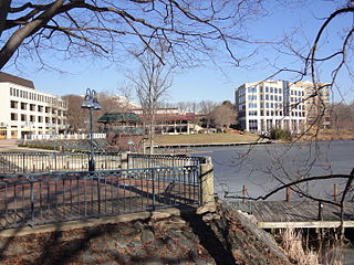
Lake Kittamaqundi is a man made 27-acre (110,000 m2) reservoir located in Columbia, Maryland in the vicinity of the Mall in Columbia as well as Merriweather Post Pavilion. It is also adjacent to offices and visible from US-29.

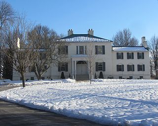
Dorsey Hall is a historic home in Columbia, Maryland, United States. It is a six-by-one-bay, 2+1⁄2-story stucco structure with a gable roof covered with asphalt shingles. It is a well-preserved and detailed example of the vernacular dwellings of the early 19th century in Howard County and associated with the Dorsey family, one of the "first families" of the county.
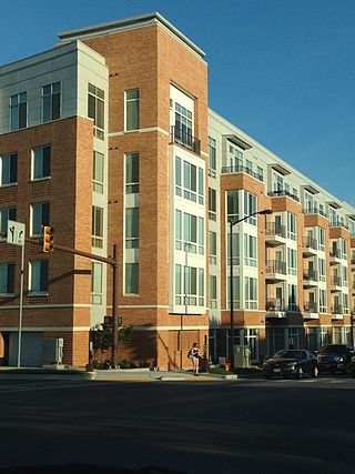
Town Center is one of the ten villages in Columbia, Maryland, United States, first occupied in 1974. The Town Center is a non-contiguous, diverse area, and the most urban-like, ranging from multi-level high density apartments, homes and office buildings to single family homes.
The Middle Patuxent Environmental Area (MPEA) is a 1,021-acre (4.13 km2) wildlife area in Clarksville, Maryland and operated by the Howard County Department of Recreation and Parks. It is located next to the River Hill village in the town of Columbia, Maryland, in the United States. The MPEA was created in 1996 for educational, research, and recreational purposes.
Melvin James Berman, was a prominent land developer in Maryland. He was instrumental in the creation of Columbia, Maryland along with his development partner James Rouse.
Oakland or Oakland Manor is a Federal style stone manor house commissioned in 1810 by Charles Sterrett Ridgely in the Howard District of Anne Arundel County Maryland. The lands that became Oakland Manor were patented by John Dorsey as "Dorsey's Adventure" in 1688 which was willed to his grandson Edward Dorsey. In 1785, Luther Martin purchased properties named "Dorsey's Adventure", "Dorsey's Inheritance", "Good for Little", "Chew's Vineyard", and "Adam the First" to make the 2300 acre "Luther Martin's Elkridge Farm".
Elioak is an unincorporated community in Howard County, Maryland, United States. It was the home of the "Pushpin Farm", a 200-acre slave plantation purchased in 1724 in the Howard District of Anne Arundel County by Col. Edward Dorsey and which is the site of many prominent Dorsey family graves. The postal community was named after the Elioak plantation built by Owen Dorsey, Judge of the Baltimore Orphans' Court. A postal office operated in the community from 12 June 1893 to 15 September 1922. Local farm orchards were known for prize winning apples and pears. Local families such as the Kahler, Miller, and Worthington claimed Elioak as home while they served in World War I. After the war, the name fell out of use.
Arlington is a historic slave plantation located in Columbia, Howard County, Maryland, now part of the Fairway Hills Golf Course.

The Dasher Farm is a historic farm located in Columbia, Howard County, Maryland, now part of the Rouse Company land development.

