Jonestown, Howard County, Maryland

Last updated

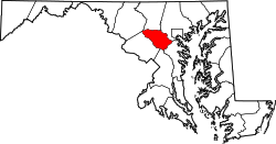
Jonestown is an unincorporated community in Howard County, Maryland, United States.

Contents

The Jonestown area was a historic African American community near Ellicott City that was centered on the crossroads where Howard High School is presently located. The town's identity has been mostly absorbed into Ellicott City and Columbia's Long Reach village. [1]
History

Jonestown appeared on Martenet's 1860 map of Howard County, [2] George Kaiser's 1863 map of Baltimore County, [3] and Martenet's 1865 map of Maryland. [4]

See also

Related Research Articles

<span class="mw-page-title-main">Howard County, Maryland</span> County in Maryland, United States

Howard County is located in the U.S. state of Maryland. As of the 2020 census, the population was 334,529. Since there are no incorporated municipalities, there is no incorporated county seat either. Therefore, its county seat is the unincorporated community of Ellicott City. Howard County is included in the Baltimore-Columbia-Towson, MD Metropolitan Statistical Area, which is part of the larger Washington–Baltimore combined statistical area.

<span class="mw-page-title-main">Elkridge, Maryland</span> Census-designated place in Maryland, United States of America

Elkridge is an unincorporated community and census-designated place (CDP) in Howard County, Maryland, United States. The population was 15,593 at the 2010 census. Founded early in the 18th century, Elkridge is adjacent to two other counties, Anne Arundel and Baltimore.

<span class="mw-page-title-main">Ellicott City, Maryland</span> Census-designated place in Maryland, United States

Ellicott City is an unincorporated community and census-designated place in, and the county seat of, Howard County, Maryland, United States. Part of the Baltimore metropolitan area, its population was 65,834 at the 2010 census, making it the most populous unincorporated county seat in the country.

<span class="mw-page-title-main">Oella, Maryland</span> Historic district in Maryland, United States

Oella is a mill town on the Patapsco River in western Baltimore County, Maryland, United States, located between Catonsville and Ellicott City. It is a 19th-century village of millworkers' homes.

<span class="mw-page-title-main">Maryland Route 108</span> State highway in Maryland, US

Maryland Route 108 is a state highway in the U.S. state of Maryland. The highway runs 34.23 miles (55.09 km) from MD 27 in Damascus east to MD 175 in Columbia. MD 108 is an S-shaped highway that winds through the northern Montgomery County and central Howard County. The highway connects the Montgomery County communities of Laytonsville, Olney, Sandy Spring, and Ashton with the Howard County villages of Highland and Clarksville. MD 108 serves as the northern edge of Columbia and connects several of the planned community's suburban villages.

<span class="mw-page-title-main">Maryland's 2nd congressional district</span> U.S. House district for Maryland

Maryland's 2nd congressional district elects a representative to the United States House of Representatives every two years. The district comprises parts of Carroll and Baltimore counties, as well as small portions of the City of Baltimore. The seat has been represented by Dutch Ruppersberger of the Democratic Party since 2003.

The Howard County Public School System (HCPSS) is the school district that manages and runs the public schools of Howard County, Maryland. It operates under the supervision of an elected, eight-member Board of Education. Antonia Watts is the chair of the board. Michael J. Martirano has served as the superintendent since May 2017.

<span class="mw-page-title-main">Maryland's 3rd congressional district</span> U.S. House district for Maryland

Maryland's 3rd congressional district comprises all of Howard county as well as parts of Anne Arundel and Carroll counties. The seat is currently represented by John Sarbanes, a Democrat.

<span class="mw-page-title-main">Maryland Route 104</span> State highway in Howard County, Maryland, known as Waterloo Rd

Maryland Route 104 is a state highway in the U.S. state of Maryland. Known as Waterloo Road, the state highway runs 1.14 miles (1.83 km) from MD 108 in Columbia north to MD 103 in Ellicott City. MD 104 connects MD 108, MD 103, and MD 100 in northeastern Howard County. The state highway was originally constructed as MD 531 in the early 1930s and became part of MD 175 in the mid-1940s. After MD 175 was rerouted through Columbia in the late 1970s, MD 104 was assigned to its present course.

<span class="mw-page-title-main">St. Charles College (Maryland)</span> Historic district in Maryland, United States

St. Charles College was a minor seminary in Catonsville, Maryland, originally located in Ellicott City, Maryland.

<span class="mw-page-title-main">Maryland Route 99</span> State highway in Howard County, Maryland, US, known as Old Frederick Rd

Maryland Route 99 is a state highway in the U.S. state of Maryland. Known as Old Frederick Road, the state highway runs 7.57 miles (12.18 km) from MD 32 near West Friendship east to U.S. Route 29 in Ellicott City. MD 99 parallels the north side of Interstate 70 (I-70) through a rural and suburban area in northeastern Howard County. MD 99, which follows the original 18th-century road west from Baltimore, was constructed as part of three state highways: MD 99, the original MD 100, and MD 105. All three highways were constructed between the early 1920s and early 1930s. MD 99 originally turned south along St. Johns Lane to US 40 and MD 144; in 1956, the state highway was rerouted along part of MD 100 and all of MD 105 to downtown Ellicott City. MD 99's eastern terminus was rolled back to US 29 in two steps in the late 1970s and late 1980s.

<span class="mw-page-title-main">Baltimore metropolitan area</span> Metropolitan area in Maryland, United States

The Baltimore–Columbia–Towson Metropolitan Statistical Area, also known as Central Maryland, is a metropolitan statistical area (MSA) in Maryland as defined by the United States Office of Management and Budget (OMB). It is part of the larger Washington–Baltimore combined statistical area. As of 2022, the combined population of the seven counties is 2,985,871, making it the 20th-largest metropolitan statistical area in the nation.

<span class="mw-page-title-main">Ilchester, Maryland</span> Census-designated place in Maryland

Ilchester is an unincorporated community and census-designated place in Howard County, Maryland, United States. The population was 23,476 at the 2010 census. It was named after the village of Ilchester in the English county of Somerset.

The Historical Ellicott City/Baltimore Trolley Line #9 Trail is a 1.25-mile (2.0 km) trail in western Baltimore County, Maryland. It begins at the west end of Edmondson Avenue and extends from Catonsville through Oella to Main Street, Ellicott City. The trail follows what was originally part of the Catonsville and Ellicott City Electric Railway Company trolley line that shuttled passengers between Ellicott City and Baltimore from the late 1890s to the mid-1950s.

Rock Hill College was a boys' boarding school located in Ellicott City, Maryland. The school was divided into two departments: preparatory and collegiate. The curriculum was based on physical education, sciences, and classical studies

The David Force Natural Resource Area is a 221-acre (89 ha) wildlife area in Ellicott City, Maryland. It is located between Route 70 and 40 adjacent to the Turf Valley development in Howard County, Maryland, and operated by the Howard County Department of Recreation and Parks.

<span class="mw-page-title-main">Ellicott City Jail</span> Historic county jail in Ellicott City, Maryland

Elysville is an unincorporated community in Howard County, Maryland, United States. A postal stop operated between February 22, 1834, and February 3, 1854.

<span class="mw-page-title-main">Guilford Road</span>

Guilford Road is a historic road north of Savage, Maryland that traverses Anne Arundel and Howard Counties in an area that was first settled by English colonists in the mid-1600s. Today's Guilford road is a series of disconnected segments bisected multiple times by the construction of Maryland Route 32.

<span class="mw-page-title-main">East Columbia Business District, Columbia, Maryland</span> Business District in Maryland, United States

The East Columbia Business District is a section of the planned community of Columbia, Maryland, United States that features a number of large shopping centers and office parks. This district also includes the Columbia Gateway Business Park, which is home to more than 50 companies employing over 17,000 individuals. The business district provides shopping resources for much of Northeastern Howard County. Many locals refer to the area simply as "Dobbin" or "Snowden" due to the major roadways that serve it.

References

  1. Alice Cornelison; Silas E. Craft Sr.; Lillie Price. History of Blacks In Howard County. p. 40.
  2. Martenet, Simon J. (1860). "Martenet's Map of Howard County, Maryland : drawn entirely from actual surveys". Library of Congress .
  3. Kaiser, George (1863). "Military map, Baltimore Co., Md". Library of Congress .
  4. Martenet, Simon J. (1886). "Martenet's map of Maryland : including the District of Columbia, a sketch of Delaware, and a portion of northern and eastern Virginia showing some of the most interesting localities of the late war". Library of Congress .

39°13′19″N76°48′27″W / 39.22194°N 76.80750°W / 39.22194; -76.80750