Clarkson, Maryland

Last updated

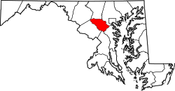
Clarkson is an unincorporated community in Howard County, Maryland, United States. A postal office operated in the community from 14 September 1889 to 31 October 1931. [1] [2] [3] Clarkson was the site of strategic simulations by the U.S. Army in 1922 training manuals. [4]

Unincorporated area Region of land not governed by own local government

In law, an unincorporated area is a region of land that is not governed by a local municipal corporation; similarly an unincorporated community is a settlement that is not governed by its own local municipal corporation, but rather is administered as part of larger administrative divisions, such as a township, parish, borough, county, city, canton, state, province or country. Occasionally, municipalities dissolve or disincorporate, which may happen if they become fiscally insolvent, and services become the responsibility of a higher administration. Widespread unincorporated communities and areas are a distinguishing feature of the United States and Canada. In most other countries of the world, there are either no unincorporated areas at all, or these are very rare; typically remote, outlying, sparsely populated or uninhabited areas.

Howard County, Maryland County in Maryland

Howard County is a county in the central part of the U.S. state of Maryland. As of the 2010 census, the population was 287,085. Its county seat is Ellicott City.

Maryland State in the United States

Maryland is a state in the Mid-Atlantic region of the United States, bordering Virginia, West Virginia, and the District of Columbia to its south and west; Pennsylvania to its north; and Delaware to its east. The state's largest city is Baltimore, and its capital is Annapolis. Among its occasional nicknames are Old Line State, the Free State, and the Chesapeake Bay State. It is named after the English queen Henrietta Maria, known in England as Queen Mary, who was the wife of King Charles I.

39°17′53″N76°56′08″W / 39.29806°N 76.93556°W / 39.29806; -76.93556 [5]

See also

Related Research Articles

Clarksville, Maryland Unincorporated community in Maryland

Clarksville is an unincorporated community in Howard County, Maryland; the second highest-earning county in the United States according to the U.S. Census Bureau. The community is named for William Clark, a farmer who owned much of the land on which the community now lies and served as a postal stop that opened on the 4th of July 1851.

Millersville, Maryland Unincorporated community in Maryland, United States

Millersville is an unincorporated community in Anne Arundel County, Maryland, United States. Population was 20,965 in 2015 based on American Community Survey data.

Highland, Maryland Census-designated place in Maryland

Highland is an unincorporated community and census-designated place in Howard County, Maryland, United States. As of the 2010 census it had a population of 1,034. It uses the 20777 zip code.

Dayton, Maryland Place in Maryland

Dayton is an unincorporated community located in Howard County, Maryland, United States.

Cornelius, Indiana Unincorporated community in Indiana, United States

Cornelius is an unincorporated community in Jackson Township, Brown County, Indiana.

Mott Station, Indiana Unincorporated community in Indiana, United States

Mott Station is an unincorporated community in Jackson Township, Harrison County, Indiana.

Daniels, Maryland Place

Daniels is a ghost town straddling the Patapsco River east of Woodstock and north of Old Ellicott City in [[Baltimore County, Maryland|Baltimore] and Howard counties, Maryland, United States. It is the location of the Daniels Mill, a site listed on the National Register of Historic Places. Daniels is the home town of former Howard County Executive and State Senator James N. Robey. A postal office operated in the community from 1 March 1943 to 31 August 1971.

Cooksville is an unincorporated community in Howard County, Maryland, United States. As of 2016, the population was 631. The town was founded by Thomas Cook in 1802. The crossroads town was anchored by the Joshua Roberts Tavern, where General Lafayette visited in 1824. The inn was destroyed by fire, rebuilt, and demolished a second time. Thomas Cook exchanged his stake in Cooksville with Thomas Beale Dorsey for the 231-acre Round About Hills slave plantation. A Post Office opened on the 4th of July 1851, the same year Howard County was formed from a portion of Anne Arundel County. Roberts Inn was listed on the National Register of Historic Places in 1973.

Glenwood, Howard County, Maryland unincorporated community in Howard County, Maryland, United States

Glenwood is an unincorporated community in Howard County, Maryland, United States. It is located between Baltimore and Washington, D.C., therefore attracting commuters to those employment centers. The community features acres of open space and is districted to Bushy Park Elementary, Glenwood and Folly Quarter Middle, and Glenelg High schools. Union Chapel was listed on the National Register of Historic Places in 1975 and Round About Hills was added in 2008.

Ednor is an unincorporated community in Montgomery County, Maryland, United States.

Atholton is an unincorporated community in Howard County, Maryland, United States. A postal office operated from May 26, 1897 to November 1900 and again from 1903 to July 1917.

Alberton is an unincorporated community in Howard County, Maryland, United States. A postal office operated in the community from 3 February 1854 to 1 March 1943.

Alpha is an unincorporated community in Howard County, Maryland, United States. A postal office operated from 27 February 1884 to 15 June 1915.

Elioak is an unincorporated community in Howard County, Maryland, United States. It was the home of the "Pushpin Farm", a 200-acre slave plantation purchased in 1724 in the Howard District of Anne Arundel County by Col. Edward Dorsey and which is the site of many prominent Dorsey family graves. The postal community was named after the Elioak plantation built by Owen Dorsey, Judge of the Baltimore Orphans' Court. A postal office operated in the community from 12 June 1893 to 15 September 1922. Local farm orchards were known for prize winning apples and pears. Local families such as the Kahler, Miller, and Worthington claimed Elioak as home while they served in World War I. After the war, the name fell out of use.

Elysville is an unincorporated community in Howard County, Maryland, United States. A postal stop operated between February 22, 1834, and February 3, 1854.

Florence is an unincorporated community in Howard County, Maryland, United States. A postal stop operated in Florence between June 17, 1868 and March 31, 1906. Governor Edwin Warfield taught in the neighborhood one room schoolhouse.

Gary is an unincorporated community in Howard County, Maryland, United States. A postal stop operated between February 2, 1892 and June 13, 1918. The town is located at the crossroads of Sharp and Tridelphia Road near modern Woodbine, Maryland.

High Ridge is an unincorporated community in Howard County, Maryland, United States. A postal stop operated from May 25, 1892, through December 1895 and until May 1899 as "Highridge".

Ivory, Maryland Place in Maryland

Ivory is an unincorporated community located at the northwest tip of Howard County, Maryland, United States. It is located between modern Glenelg and West Friendship.

East Liberty is an unincorporated community in Allen County, Indiana, in the United States.

References

  1. "Checklist of Maryland Post Offices" (PDF). Smithsonian National Postal Museum. 12 July 2007. Archived from the original (PDF) on 18 May 2014. Retrieved 17 May 2014.
  2. J. Onwhyn (1909). The Lancet, Volume 2, Part 1.
  3. Rand McNally International Bankers Directory. 1911. p. 1259.
  4. United States. General Service Schools. Fort Leavenworth. Kan. Tactical and Strategical Studies: Corps and Army.
  5. "Clarkson, Maryland Latitude/Longitude". Lat-Long.com. Retrieved 19 August 2014.