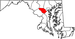
Woodstock, Maryland

Last updated
Woodstock, Maryland
USA Maryland location map.svg
Red pog.svg
Woodstock
Location in Maryland
Coordinates: 39°19′43″N76°52′19″W / 39.32861°N 76.87194°W / 39.32861; -76.87194 Coordinates: 39°19′43″N76°52′19″W / 39.32861°N 76.87194°W / 39.32861; -76.87194
Country Flag of the United States.svg  United States of America
State Flag of Maryland.svg  Maryland
County Flag of Howard County, Maryland.svg Howard
Elevation
[1]
318 ft (97 m)
Population
 (2010) [2]
  Total6,986
Time zone UTC-5 (Eastern)
  Summer (DST) UTC-4 (EDT)
ZIP code
21163
Area code 410, 443, 667
GNIS 591607 [1]

Woodstock is an unincorporated community which is a suburb of Baltimore, Maryland, United States. The original village of Woodstock is located in Howard County, and also includes portions of Baltimore County and Carroll County. [3]

Contents

History

Thomas Browne explored westward through Anne Arundel county through Clarksville and settled in the area in 1702. The Mt. Pleasant Log home was built by the Brown family in the 18th century. A century later in the civil war, confederate general Bradley Tyler Johnson used Mt. Pleasant to store weapons, dispatch messages and hide from Union troops. [4]

Woodstock was founded as a mining town based around its Granite quarries. The B&O railroad ran through the area with a station built in 1835 for granite deliveries. The postal community was named "Davis Tavern" when its first post office opened in 1836. Caleb Davis and Peter Gorman were early B&O contractors. Gorman married Elizabeth Browne of the Brown family, occupied a large farm "Good Fellowship", sold Granite for buildings and built a large granite house in town. The granite house was the birthplace of Arthur Pue Gorman, which was torn down to build a bridge across the Patapsco in the early 1980s. In 1869, the Jesuit Woodstock College opened on the Baltimore side of the Patapsco River. St, Alphonsus Rodriguez church was built on a section of the institute in 1887–1968 when it was lost to fire. In 1889, telegraph service was extended to town. [4]

Demographics

As of 2010, Woodstock's population is 6,986. The population growth rate is 31.51%. [2]

Housing market

According to Sperling's BestPlaces, Woodstock's cost of living is 49.9% higher than the U.S. average, and the median cost per home in Woodstock is $422,290[ when? ] [2]

Schools

Public schools in the area spend $6,343 per student, $665 more than the U.S. median. There are an average of 14.9 students per teacher. [2]

Woodmont Academy opened in Woodstock in 1995. [5] It would later close during a series of reforms and restructuring that its patron, the Legion of Christ, underwent.

People

Related Research Articles

<span class="mw-page-title-main">Arbutus, Maryland</span> Census-designated place in Maryland, United States

Arbutus is an unincorporated community and a census-designated place in Baltimore County, Maryland, United States. The population was 20,483 at the 2010 census. The census area also contains the communities of Halethorpe and Relay, in which all three names were used during the 1960 census when the area had a population of 22,402.

<span class="mw-page-title-main">Catonsville, Maryland</span> Census-designated place in Maryland, United States

Catonsville is a census-designated place (CDP) in Baltimore County, Maryland, United States. The population was 41,567 at the 2010 census. The community lies to the west of Baltimore along the city's border. Catonsville contains the majority of the University of Maryland, Baltimore County (UMBC), a major public research university with close to 14,000 students.

<span class="mw-page-title-main">Sykesville, Maryland</span> Town in Maryland, United States

Sykesville is a small town in Carroll County, Maryland, United States. The town lies 20 miles (32 km) west of Baltimore and 40 miles (64 km) north of Washington D.C. The population was 4,436 at the 2010 census. BudgetTravel.com named Sykesville 'Coolest Small Town in America' in June 2016.

<span class="mw-page-title-main">Elkridge, Maryland</span> Census-designated place in Maryland, United States of America

Elkridge is an unincorporated community and census-designated place (CDP) in Howard County, Maryland, United States. The population was 15,593 at the 2010 census. Founded early in the 18th century, Elkridge is adjacent to two other counties, Anne Arundel and Baltimore.

<span class="mw-page-title-main">Ellicott City, Maryland</span> Census-designated place in Maryland, United States

Ellicott City is an unincorporated community and census-designated place in, and the county seat of, Howard County, Maryland, United States. Part of the Baltimore metropolitan area, its population was 65,834 at the 2010 census, making it the most populous unincorporated county seat in the country.

<span class="mw-page-title-main">Mount Airy, Maryland</span> Town in Maryland

Mount Airy is a town in Carroll and Frederick counties in the U.S. state of Maryland. It is part of both the Washington Metropolitan Area and Baltimore Metropolitan Area. As of the 2010 census the population was 9,288.

<span class="mw-page-title-main">Patapsco River</span> River in Maryland, United States

The Patapsco River mainstem is a 39-mile-long (63 km) river in central Maryland which flows into the Chesapeake Bay. The river's tidal portion forms the harbor for the city of Baltimore. With its South Branch, the Patapsco forms the northern border of Howard County, Maryland. The name "Patapsco" is derived from the Algonquian pota-psk-ut, which translates to "backwater" or "tide covered with froth."

<span class="mw-page-title-main">Woodbine, Maryland</span> Unincorporated community in Maryland, United States

Woodbine is an unincorporated rural community in Howard and Carroll counties, Maryland, United States. It is part of the Baltimorean metropolitan area. It is located southeast of Frederick, west of Baltimore, north of Washington, D.C., and east of Mount Airy. The community was named for the woodbine plant, which grew in the community in fields and along riverbanks.

<span class="mw-page-title-main">Thomas Viaduct</span> Railroad bridge in Maryland, US

The Thomas Viaduct spans the Patapsco River and Patapsco Valley between Relay, Maryland and Elkridge, Maryland, USA. It was commissioned by the Baltimore and Ohio Railroad (B&O); built between July 4, 1833, and July 4, 1835; and named for Philip E. Thomas, the company's first president. It remains the world's oldest multiple arched stone railroad bridge.

<span class="mw-page-title-main">Maryland Route 144</span> State highway in Maryland, US

Maryland Route 144 is a collection of state highways in the U.S. state of Maryland. These highways are sections of old alignment of U.S. Route 40 between Cumberland and Baltimore. Along with US 40 Scenic, US 40 Alternate, and a few sections of county-maintained highway, MD 144 is assigned to what was once the main highway between the two cities, connecting those endpoints with Hancock, Hagerstown, Frederick, New Market, Mount Airy, Ellicott City, and Catonsville. MD 144 has seven disjoint sections of mainline highway that pass through the Appalachian Mountains in Allegany and Washington counties and the rolling Piedmont of Frederick, Carroll, Howard, and Baltimore counties.

<span class="mw-page-title-main">Maryland Route 99</span> State highway in Howard County, Maryland, US, known as Old Frederick Rd

Maryland Route 99 is a state highway in the U.S. state of Maryland. Known as Old Frederick Road, the state highway runs 7.57 miles (12.18 km) from MD 32 near West Friendship east to U.S. Route 29 in Ellicott City. MD 99 parallels the north side of Interstate 70 (I-70) through a rural and suburban area in northeastern Howard County. MD 99, which follows the original 18th-century road west from Baltimore, was constructed as part of three state highways: MD 99, the original MD 100, and MD 105. All three highways were constructed between the early 1920s and early 1930s. MD 99 originally turned south along St. Johns Lane to US 40 and MD 144; in 1956, the state highway was rerouted along part of MD 100 and all of MD 105 to downtown Ellicott City. MD 99's eastern terminus was rolled back to US 29 in two steps in the late 1970s and late 1980s.

<span class="mw-page-title-main">Old Main Line Subdivision</span>

The Old Main Line Subdivision is a railroad line owned and operated by CSX Transportation in the U.S. state of Maryland. The line runs from Relay west to Point of Rocks, and was once the main line of the Baltimore and Ohio Railroad, one of the oldest rail lines in the United States. At its east end, it has junctions with the Capital Subdivision and the Baltimore Terminal Subdivision; its west end has a junction with the Metropolitan Subdivision.

<span class="mw-page-title-main">Ilchester, Maryland</span> Census-designated place in Maryland

Ilchester is an unincorporated community and census-designated place in Howard County, Maryland, United States. The population was 23,476 at the 2010 census. It was named after the village of Ilchester in the English county of Somerset.

Old Court Road is a state- and county-maintained highway in the U.S. state of Maryland. Including the adjacent road in Howard County known as Woodstock Road, the highway runs 15.4 miles (24.8 km) from Maryland Route 99 near Woodstock east to Joppa Road near Towson. Old Court Road includes two county-maintained sections and two Maryland state highways, Maryland Route 125 and Maryland Route 133. MD 125 has a length of 3.59 miles (5.78 km) between Woodstock and the edge of Randallstown and MD 133 spans 3.31 miles (5.33 km) between MD 129 and MD 25 in Pikesville. Old Court Road connects the western and central Baltimore County communities of Granite, Randallstown, Milford Mill, Pikesville, and Towson. Old Court Road has been a cross-county highway since the colonial era. The highway was fully paved in Baltimore County by the mid-1920s, including the sections of the highway that became MD 125 and MD 133. MD 133 was extended west to MD 140 and MD 125 was extended west to MD 99 in the early 1930s; MD 125's terminus returned to the Patapsco River in the mid-1950s. Old Court Road was relocated at its eastern end in the early 1960s and in Pikesville in the late 1960s, at which time MD 133 assumed its current course.

<span class="mw-page-title-main">Howard County Conservancy</span> Land trust and nature center in Maryland, United States

The Howard County Conservancy is a non-profit land trust that operates a nature center in Woodstock, Maryland. It is located at the 300-year-old, 232-acre (0.94 km2) Mt. Pleasant Farm.

<span class="mw-page-title-main">Woodstock Quartz Monzonite</span>

The Woodstock Quartz Monzonite is a Silurian or Ordovician quartz monzonite pluton in Baltimore County, Maryland. It is described as a massive biotite-quartz monzonite which intrudes through the Baltimore Gneiss at a single locality surrounding the town of Granite, Maryland.

<span class="mw-page-title-main">Ellicott City Granodiorite</span>

The Ellicott City Granodiorite is a Silurian or Ordovician granitic pluton in Howard and Baltimore Counties, Maryland. It is described as a biotite granodiorite along the margin of the intrusion which grades into a quartz monzonite in its core. It intrudes through the Wissahickon Formation and the Baltimore Gabbro Complex.

<span class="mw-page-title-main">Peter Gorman</span> American businessman

Peter Gorman was one of the first contractors of the Baltimore and Ohio Railroad. His son Arthur Pue Gorman would go on to become a Senator and pioneer in baseball. His other son William Henry Gorman would become a prominent businessman.

<span class="mw-page-title-main">Woodmont Academy</span> Former private school in Cooksville, Maryland, United States

Woodmont Academy was a private school in Howard County, Maryland, affiliated with the Legionaries of Christ, a Catholic religious institute.

<span class="mw-page-title-main">Patapsco Valley</span> Valley surrounding the Patapsco River in the U.S. state of Maryland

The Patapsco Valley is a small valley surrounding the Patapsco River in central Maryland. The region is known for its historical significance as a major economic and industrial center in the eighteenth and nineteenth centuries.

References

  1. 1 2 U.S. Geological Survey Geographic Names Information System: Woodstock, Maryland
  2. 1 2 3 4 "Zip Code Overview". Sperling's BestPlaces. Retrieved 2010-09-19.
  3. Howard County Historical Society. Images of America Howard County. p. 41.
  4. 1 2 Barbara Feaga. Howard's Roads to the Past. p. 53.
  5. "Our Mission." Woodmont Academy. February 6, 2001. Retrieved on February 2, 2018.
  6. News services and staff reports (December 28, 2013) "Star center fielder won two titles with Orioles" The Washington Post, page B4. Retrieved December 28, 2013