Dalian University is a university in Dalian, Liaoning, China under the provincial government.
Established in January 2005, the University System of Maryland at Hagerstown is a facility located in Hagerstown, Maryland that offers upper-level undergraduate and graduate programs to residents of Hagerstown and its surrounding region.

Sugar Creek is an unincorporated community in Moral Township, Shelby County, in the U.S. state of Indiana.

Catoctin Creek is a 27.9-mile-long (44.9 km) tributary of the Potomac River in Frederick County, Maryland, USA. Its source is formed in the Myersville, Maryland area and flows directly south for the entire length of the stream. Catoctin Creek enters the Potomac River east of Brunswick. The stream flows through Catoctin Creek Park.

Zderaz is a small village in the Pardubice Region of the Czech Republic. It has around 300 inhabitants.

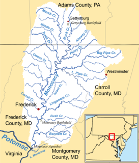
Marsh Creek is a 26.6-mile-long (42.8 km) tributary of the Monocacy River in south-central Pennsylvania and north-central Maryland in the United States.
Little Conococheague Creek is a 12.4-mile-long (20.0 km) tributary stream of the Potomac River in the U.S. states of Maryland and Pennsylvania. The stream rises on Two Top Mountain, west of the Whitetail Ski Resort in Franklin County, Pennsylvania, and proceeds south into Washington County, Maryland. It empties into the Potomac about 2 miles (3 km) southeast of Big Spring, Maryland. The watershed of the creek is 18 square miles (47 km2) and includes Indian Springs Wildlife Management Area. Tributaries include Toms Run.
Oakmont, Maryland is a village and special taxing district in Montgomery County, Maryland. Chartered in 1918, the village includes both sides of Oak Place and the south side of Oakmont Avenue, across Old Georgetown Road from the National Institutes of Health, in the Bethesda, Maryland postal area. The village has approximately 145 inhabitants in 52 homes.

Lakelands Park is a City of Gaithersburg park in Montgomery County, Maryland. It is located in the Lakelands neighborhood. The park includes two baseball/softball fields, a playground, and a large grassy area usually used for soccer. This park is located next to Lakelands Park Middle School.
Ballenger Creek is a 10.7-mile-long (17.2 km) tributary of the Monocacy River in Frederick County, Maryland. The headwaters of the creek are located on the east slope of Catoctin Mountain, about 3 miles (5 km) west of the city of Frederick. The stream runs roughly southeast to the Monocacy National Battlefield and the confluence with the Monocacy River, which drains to the Potomac River. The watershed area of the creek is 21.8 square miles (56 km2).
Butte Des Morts is a region of northeastern Wisconsin, in Winnebago County, containing two known lakes: Little Lake Butte des Morts, and Lake Butte des Morts. Little Lake Butte des Morts lies between the Menasha region from the town of Menasha, while Big Lake Butte des Morts lies in the northwest side of the city of Oshkosh, Wisconsin.

Hüsülü is a village in the Lachin Rayon of Azerbaijan.

Qaracallı is a village in the Qubadli Rayon of Azerbaijan.
Southport is an unincorporated community in Bay County, Florida, United States. It is located along the north side of North Bay and west of Deer Point Lake. The main roads through the community are State Road 77, Edwards Rd, County Road 388, State Road 20 and County Road 2321. It is also part of the Panama City–Lynn Haven–Panama City Beach Metropolitan Statistical Area.
Strider Wildlife Management Area is a Wildlife Management Area in Montgomery County, Maryland.

Comus is an unincorporated community in Montgomery County, Maryland, United States. Its elevation is 591 feet (180 m). The mostly rural community is located about 39.7 miles (63.9 km) by car from Washington D.C.
Dawsonville is an unincorporated community in Montgomery County, Maryland.

Double Pipe Creek, sometimes called Pipe Creek, is a major tributary of the Monocacy River in Carroll County and Frederick County in Maryland, located several miles north and west of Westminster. The creek is only 1.6 miles (2.6 km) long, but is formed by the confluence of two much longer streams, Big Pipe Creek and Little Pipe Creek.
Tuscarora Creek is a 7.7-mile-long (12.4 km) tributary of the Monocacy River in Frederick County, Maryland, in the United States.

Tuscarora Creek is a 12.8-mile-long (20.6 km) tributary of the Potomac River in Frederick County, Maryland, in the United States.


