Middleburg may refer to several places:

Middleburg is a town in Loudoun County, Virginia, United States. The population was 673 at the 2010 census.
There are over 30 lakes named Mud Lake within the U.S. state of New York.

South Carroll High School (SCHS) is a four-year public high school in Sykesville in Carroll County, Maryland, United States. The school is located near the southwest corner of Carroll County on Liberty Road between Maryland Route 27 and Maryland Route 97.

Maryland Route 77 is a state highway in the U.S. state of Maryland. The state highway runs 20.74 miles (33.38 km) from MD 64 in Smithsburg east to MD 194 in Keymar. MD 77 is the main east–west highway of northern Frederick County. The state highway connects Thurmont with eastern Washington County via Foxville, which lies between South Mountain and Catoctin Mountain near Catoctin Mountain Park and Cunningham Falls State Park. MD 77 links Thurmont with western Carroll County through the communities of Graceham, Rocky Ridge, and Detour in the Monocacy River valley. MD 77 was constructed from Thurmont east to Detour in the 1920s and early 1930s. A disjoint section of MD 77 was built between Cavetown and Foxville in the late 1930s. The portions of the modern highway between Foxville and Thurmont and from Detour to Keymar were county highways until they were designated part of MD 77 in 1956. MD 77's western terminus was moved east to MD 64 in Smithsburg in 1960.
Mexico is an unincorporated community in Carroll County, Maryland. It lies at an elevation of 968 feet.
Union Mills is an unincorporated community in Carroll County, Maryland, United States. The community is home to the Union Mills Homestead Historic District, added to the National Register of Historic Places in 1971. The Solomon Arter House was listed in 1987 and the Philip and Uriah Arter Farm in 2006.

Uniontown is an unincorporated community in Carroll County, Maryland, United States. The community is home to the Uniontown Historic District, added to the National Register of Historic Places in 1986.
Linwood is an unincorporated community in Carroll County, Maryland, United States. The community is home to the Linwood Historic District, added to the National Register of Historic Places in 1980.

Keysville is an unincorporated community in Carroll County, Maryland, United States. Terra Rubra was listed on the National Register of Historic Places in 1978.

Keymar is an unincorporated community in Carroll County, Maryland, United States. The name of the community is a combination of the family name Key and Mar for Maryland. In 1822, Francis Scott Key sold his father's mansion and estate on Pipe Creek near this community. Keymar was likely the name of that estate.
Mayberry is an unincorporated community in Carroll County, Maryland, United States. It is served by the Westminster post office, with a ZIP Code of 21158.
Silver Run is an unincorporated community in Carroll County, Maryland, United States.Christopher Erb House was listed on the National Register of Historic Places in 1985.
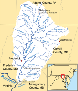
Double Pipe Creek, sometimes called Pipe Creek, is a major tributary of the Monocacy River in Carroll County and Frederick County in Maryland, located several miles north and west of Westminster. The creek is only 1.6 miles (2.6 km) long, but is formed by the confluence of two much longer streams, Big Pipe Creek and Little Pipe Creek.
Tuscarora Creek is a 7.7-mile-long (12.4 km) tributary of the Monocacy River in Frederick County, Maryland, in the United States.
Parr's Ridge is a ridge which forms the summit of the Piedmont Plateau region in the U.S. state of Maryland.
Hood's Mill is an unincorporated community located in Howard County and Carroll County in the state of Maryland in the United States of America.
North Woodbury is an unincorporated community in Morrow County, in the U.S. state of Ohio.
Taylorsville is an unincorporated place in Carroll County, Maryland, United States. Taylorsville is located where MD 26 and MD 27 intersect, approximately 17 miles east of Frederick and 27 miles northwest of Baltimore. Taylorsville is near Morgan Run Natural Environment Area.
Woodland is an unincorporated community in Marion County, in the U.S. state of Missouri.


