Dorsey, Maryland

Last updated
Dorsey, Maryland
USA Maryland location map.svg
Red pog.svg
Dorsey
Coordinates: 39°10′38″N76°44′35″W / 39.17722°N 76.74306°W / 39.17722; -76.74306 Coordinates: 39°10′38″N76°44′35″W / 39.17722°N 76.74306°W / 39.17722; -76.74306
Country Flag of the United States.svg United States
State Flag of Maryland.svg  Maryland
County Flag of Howard County, Maryland.svg Howard
Founded1881
Time zone UTC-5 (Eastern (EST))
  Summer (DST) UTC-4 (EDT)
ZIP
21075
Area code(s) 410 & 443

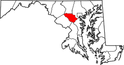
Dorsey, Maryland, is an unincorporated community along the border of eastern Howard County and northwestern Anne Arundel County in Maryland, United States. It is located south of Elkridge, north of Savage, and close to Baltimore-Washington International Airport (BWI). It is in the southern part of the Baltimore metropolitan area.

Dorsey is perhaps listed as a former postal stop that operated from December 1881 on the B&O railroad and is now a MARC commuter rail system stop, which carries commuters into downtown Baltimore and Washington, D.C. [1] [2] Dorsey is a stop on MARC's Camden line and contains a large parking lot off Maryland State Highway 100. Dorsey station mainly serves commuters from Elkridge and Ellicott City, as well as the northern parts of Columbia. Howard Transit buses connect Dorsey station with various locations around Howard County as well as with the nearby Arundel Mills mall.

Businesses in the area include hotels, warehouses, and satellite campuses for both Johns Hopkins University and the University of Maryland University College (both of which are located within the Dorsey Business Center).

The Dorsey Business Center is a 50-acre (200,000 m2) business park developed between 1984 and 1989 by Douglas Legum Development Inc. It was the first large-scale development project in this part of the Baltimore region. The Dorsey Business Center sits on the site of the former Dorsey Speedway, a stock car track, and now contains over two million square feet of office and retail space. Howard Transit buses connect the business park to the Dorsey MARC station.

Related Research Articles

Anne Arundel County, Maryland County in Maryland, United States

Anne Arundel County, also notated as AA or A.A. County, is located in the U.S. state of Maryland. As of the 2020 United States census, its population was 588,261, an increase of just under 10% since 2010. Its county seat is Annapolis, which is also the capital of the state. The county is named for Lady Anne Arundell, a member of the ancient family of Arundells in Cornwall, England, and the wife of Cecilius Calvert, 2nd Baron Baltimore (1605–1675), founder and first lord proprietor of the colony Province of Maryland.

Elkridge, Maryland Census-designated place in Maryland, United States of America

Elkridge is an unincorporated community and census-designated place (CDP) in Howard County, Maryland, United States. The population was 15,593 at the 2010 census. Founded early in the 18th century, Elkridge is adjacent to two other counties, Anne Arundel and Baltimore.

Maryland Transit Administration Public transit authority of the state of Maryland

The Maryland Transit Administration (MTA) is a state-operated mass transit administration in Maryland, and is part of the Maryland Department of Transportation. The MTA operates a comprehensive transit system throughout the Baltimore-Washington Metropolitan Area. There are 80 bus lines serving Baltimore's public transportation needs, along with other services that include the Light Rail, Metro Subway, and MARC Train. In 2021, the system had a ridership of 44,612,100, or about 124,900 per weekday as of the first quarter of 2022. With nearly half the population of Baltimore residents lacking access to a car, the MTA is an important part of the regional transit picture. The system has many connections to other transit agencies of Central Maryland, Washington, D.C., Northern Virginia, and south-central Pennsylvania : WMATA, Charm City Circulator, Regional Transportation Agency of Central Maryland, Annapolis Transit, Rabbit Transit, Ride-On, and TransIT.

<span class="mw-page-title-main">MARC Train</span> Commuter rail system in the Baltimore–Washington metropolitan area

MARC is a commuter rail system in the Baltimore–Washington metropolitan area. MARC is administered by the Maryland Transit Administration (MTA) and operated under contract by Alstom and Amtrak on track owned by CSX Transportation (CSXT) and Amtrak. In 2021, the system had a ridership of 1,291,900, or about 6,200 per weekday as of the first quarter of 2022, much less then the pre-pandemic daily ridership of 40,000 per weekday.

BWI Rail Station Intermodal passenger station in Linthicum, Maryland

BWI Airport Station is an intermodal passenger station in Linthicum, Maryland near Baltimore–Washington International Airport (BWI). It is served by Amtrak Northeast Corridor intercity trains, MARC Penn Line regional rail trains, and several local bus lines.

Maryland Route 100 State highway in Maryland, United States

Maryland Route 100 is a major east–west highway connecting U.S. Route 29 in Ellicott City and MD 177 in Pasadena. MD 100 also connects to Interstate 95 (I-95), US 1, the Baltimore–Washington Parkway, and I-97. The highway connects Howard County to the west with Anne Arundel County and the Chesapeake Bay to the east. MD 100 also provides access to the Baltimore–Washington International Airport (BWI) and the Arundel Mills shopping mall.

Hanover, Maryland Unincorporated community in Maryland, United States

Hanover is an unincorporated community in the Baltimore/Annapolis area in northwestern Anne Arundel County and eastern Howard County in the U.S. state of Maryland, located south of Baltimore.

Maryland Route 103 State highway in Maryland, United States

Maryland Route 103 is a state highway in the U.S. state of Maryland. The state highway runs 8.29 miles (13.34 km) from St. Johns Lane in Ellicott City east to Parkway Drive South in Hanover. MD 103 serves as the local complement to MD 100 from Ellicott City in northeastern Howard County through Dorsey to Hanover in northwestern Anne Arundel County. The state highway was constructed from U.S. Route 1 in Elkridge to US 29 in Ellicott City in the 1920s. MD 103's eastern terminus was relocated from Elkridge to US 1 near Dorsey in 1956. When MD 100 was constructed between Glen Burnie and Ellicott City in the 1990s, the state highway was extended to its present western and eastern termini. MD 103 replaced MD 176 from US 1 east to near MD 295.

Transportation in Washington, D.C. Overview of the transportation in Washington, DC

Washington, D.C. has a number of different modes of transportation available for use. Commuters have a major influence on travel patterns, with only 28% of people employed in Washington, D.C. commuting from within the city, whereas 33.5% commute from the nearby Maryland suburbs, 22.7% from Northern Virginia, and the rest from Washington, D.C.'s outlying suburbs.

Airport Loop

Airport Loop is the designation for the portions of state highways that form a circumferential highway around Baltimore/Washington International Thurgood Marshall Airport in Anne Arundel County in the U.S. state of Maryland. The loop runs 8.44 miles (13.58 km) through the communities of Linthicum, Ferndale, and Hanover. Airport Loop consists of a 3.47-mile (5.58 km) section of Maryland Route 170 (MD 170) along the western and northern sides of the loop; the entire 2.31-mile (3.72 km) length of MD 162 on the eastern side of the loop; and a 2.66-mile (4.28 km) segment of MD 176 on the southern side of the loop. Airport Loop intersects Interstate 195 (I-195), which provides freeway access to the airport terminal, and is connected to I-695, I-97, and MD 100 via connecting highways. The MD 170 and MD 162 sections of Airport Loop are part of the National Highway System.

Savage station MARC Camden Line rail station in Maryland, US

Savage is a passenger rail station on the MARC Camden Line between Union Station and Baltimore's Camden Station. It is officially located at 9009 Dorsey Run Road in Savage, Maryland, however Dorsey Run Road runs over the railroad tracks as well as Brock Bridge Road, which runs along the south side of the tracks and is a street-level with the station. The station straddles the line between Howard County and Anne Arundel County, with the southbound platform and parking garage located in Howard County and the northbound platform in Anne Arundel County.

Dorsey station Railway station in Howard County, Maryland, US

Dorsey is a passenger rail station on the MARC Camden Line between Washington, DC and Baltimore's Camden Station. The station is located at Exit 7 on Maryland Route 100, a.k.a.; the Paul T. Pitcher Memorial Highway. It was built by MARC in 1996 as a replacement for a former Baltimore and Ohio Railroad station located next to a 14-foot-10-inch (4.52 m) clearance bridge over Maryland Route 103. The former B&O station site is now a condominium development.

Glenwood, Howard County, Maryland

Glenwood is an unincorporated community in Howard County, Maryland, United States. It is located between Baltimore and Washington, D.C., therefore attracting commuters to those employment centers. The community features acres of open space and is districted to Bushy Park Elementary, Glenwood and Folly Quarter Middle, and Glenelg High schools. Union Chapel was listed on the National Register of Historic Places in 1975 and Round About Hills was added in 2008. The population in 2020 was approximately 3,416.

Greenbelt–BWI Thurgood Marshall Airport Express Line

No longer in service, the Greenbelt–BWI Thurgood Marshall Airport Express Line, designated Route B30, was a weekday-only bus route operated by the Washington Metropolitan Area Transit Authority between Baltimore-Washington International Thurgood Marshall Airport and the Greenbelt station of the Green and Yellow Lines of the Washington Metro. When it last ran, the line operated every 70 minutes five days a week along the Baltimore–Washington Parkway between these two locations with no intermediate stops, with the exception of the BWI Business District Light Rail Stop and Arundel Mills Mall, and the last bus leaving BWI at 10:09 pm. The trip was approximately 50 minutes long.

Annapolis Junction, Maryland Place in Maryland, United States of America

Annapolis Junction is an unincorporated community in Howard and Anne Arundel counties, Maryland, United States.

Hawkins Point, Baltimore Neighborhood in Baltimore, Maryland, United States

Hawkins Point is a neighborhood in the South District of Baltimore, located at the southern tip of the city between Curtis Bay (north) and the Anne Arundel County line (south) and Thoms Cove (east). Its land area covers 2.6 square miles (6.7 km2), and it had a population of 24 people according to the 2020 U.S. Census. The neighborhood is predominantly industrial.

Belmont Estate Historic estate located at Elkridge, Howard County, Maryland, United States

The Belmont Estate, now Belmont Manor and Historic Park, is a former plantation located at Elkridge, Howard County, Maryland, United States. Founded in the 1730s and known in the Colonial period as "Moore's Morning Choice", it was one of the earliest forced-labor farms in Howard County, Maryland. Its 1738 plantation house is one of the finest examples of Colonial Georgian architectural style in Maryland.

Elkridge Landing Historic seaport, now part of Elkridge, MD, US

Elkridge Landing was a Patapsco River seaport in Maryland, and is now part of Elkridge, Maryland. The historic Elkridge Furnace Inn site resides within the Patapsco Valley State Park.

UMBC Transit is the official bus system of the University of Maryland, Baltimore County. Along with the Maryland Transit Administration (MTA), the UMBC community has public transit access to nearby areas such as Catonsville, Arbutus, Maryland, and Baltimore City.

The BWI Business District is a neighborhood and business district in Linthicum and Hanover that features over 11,000 hotel rooms and numerous office parks and shopping centers. As the name suggests, the business district is benefited by nearby BaltimoreWashington International Airport.

References

  1. Gannett, Henry (1904). A Gazetteer Of Maryland (PDF). Washington, D.C.: Government Printing Office. p. 29. Retrieved August 27, 2022.
  2. "Checklist of Maryland Post Offices" (PDF). Smithsonian National Postal Museum. July 12, 2007. Archived from the original (PDF) on May 18, 2014. Retrieved July 7, 2014.