Carroll Park, Philadelphia

Last updated
Carroll Park
Phila FLP Haddington01.jpg
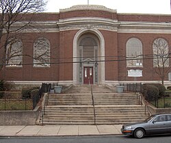
Haddington Branch Library in Carroll Park
Street map of Philadelphia and surrounding area.png
Red pog.svg
Carroll Park
Coordinates: Coordinates: 39°58′23″N75°14′10″W / 39.973°N 75.236°W / 39.973; -75.236
CountryFlag of the United States.svg  United States
State Pennsylvania
County Philadelphia County
City Philadelphia
Area code(s) 215, 267, and 445

Carroll Park is a neighborhood in West Philadelphia. Its boundaries are Lansdowne Avenue to the north, West Girard Avenue to the south, North 63rd Street to the west, and North 52nd Street to the east. [1] Along major streets of the neighborhood, the Carroll Park Community Council, Inc. has placed banners that say “Carroll Park: Where our neighbors become friends.” The 10 trolley runs along Lansdowne Avenue and the 15 trolley runs along Girard Avenue. There is a park by the name of Carroll Park between North 59th and North 58th Streets and West Thompson Street and West Girard Avenue. Carroll Park’s residents are primarily working-class and lower-income African-Americans.

Schools and libraries

The School District of Philadelphia operates the local public schools. Two charter schools and one parochial school are located in the neighborhood. The charter schools are the Universal Bluford Charter School (formerly Guion S. Bluford School), serving grades K through 6, and the Mastery Charter School – Shoemaker Campus, serving grades 7 and 8. St. Rose of Lima School is a Roman Catholic parochial school serving grades pre-K through 8. [2]

The William Shoemaker Junior High School and the former William B. Hanna School are listed on the National Register of Historic Places.

The Free Library of Philadelphia Haddington Branch serves Carroll Park. [3]

Related Research Articles

Powelton Village, Philadelphia United States historic place

Powelton Village is a neighborhood of mostly Victorian, mostly twin homes in the West Philadelphia section of the United States city of Philadelphia, Pennsylvania. It is a national historic district that is part of University City. It extends north from Market Street to Spring Garden Street, east to 32nd Street, west to 40th and Spring Garden Streets, and to 44th and Market Streets.

Wynnefield, Philadelphia Neighborhood of Philadelphia in Philadelphia County, Pennsylvania, United States

Wynnefield is a diverse middle-class neighborhood in West Philadelphia. Its borders are 53rd Street at Jefferson to the south, Philadelphia's Fairmount Park to the east, City Avenue to the north and the Amtrak Main Line tracks to the west.

Fairmount, Philadelphia Neighborhood of Philadelphia in Philadelphia County, Pennsylvania, United States

Fairmount is a neighborhood within Lower North Philadelphia. Its boundaries are north of Spring Garden Street, west of Broad Street, south of Girard Avenue and east of The Schuylkill River. While this may be the most common demarcation, the area's boundaries fluctuate depending how the neighborhood is defined. Several subdivisions exist within and near these boundaries including: Spring Garden, Franklintown and Francisville. Fairmount is commonly referred to as the "Art Museum Area," for its proximity to and association with the Philadelphia Museum of Art. Fairmount is also the location of the Eastern State Penitentiary.

Northern Liberties, Philadelphia Former District in Pennsylvania, United States

Northern Liberties is a neighborhood in Philadelphia, Pennsylvania, United States. When a city, it was the 6th largest city in the United States in 1790.

Overbrook, Philadelphia Neighborhood of Philadelphia in Philadelphia County, Pennsylvania, United States

Overbrook is a neighborhood northwest of West Philadelphia, Philadelphia, in the U.S. state of Pennsylvania. The area's housing ranges from large, old homes to rowhouses to 3- and 4-story apartment buildings.

West Philadelphia Neighborhood of Philadelphia in Philadelphia, Pennsylvania

West Philadelphia, nicknamed West Philly, is a section of Philadelphia, Pennsylvania. Though there is no official definition of its boundaries, it is generally considered to reach from the western shore of the Schuylkill River, to City Avenue to the northwest, Cobbs Creek to the southwest, and the SEPTA Media/Elwyn Line to the south. An alternate definition includes all city land west of the Schuylkill; this would also include Southwest Philadelphia and its neighborhoods. The eastern side of West Philadelphia is also known as University City.

Center City, Philadelphia Neighborhood of Philadelphia in Philadelphia, Pennsylvania

Center City includes the central business district and central neighborhoods of Philadelphia, in the U.S. state of Pennsylvania. It comprises the area that made up the City of Philadelphia prior to the Act of Consolidation, 1854 which extended the city borders to be coterminous with Philadelphia County. Greater Center City has grown into the second-most densely populated downtown area in the United States, after Midtown Manhattan in New York City, with an estimated 193,000 residents in 2018.

SEPTA Route 15 SEPTA trolley line in Philadelphia, Pennsylvania

SEPTA's Route 15, the Girard Avenue Line, is a trolley line operated by the Southeastern Pennsylvania Transportation Authority (SEPTA) along Girard Avenue through North and West Philadelphia, Pennsylvania, United States. As of 2007, it is the only surface trolley line in the City Transit Division that is not part of the Subway–Surface Trolley Lines. SEPTA PCC II vehicles are used on the line.

West Oak Lane, Philadelphia Neighborhood of Philadelphia in Philadelphia County, Pennsylvania, United States

West Oak Lane is a neighborhood in the Uptown section of Philadelphia. The neighborhood was developed primarily between the early 1920s and late 1930s, with the areas near to Cedarbrook constructed after World War II. At the northeast corner of Limekiln Pike and Washington Lane was the site of the Cedar Park Inn, a historic tavern built in the early 19th century, which was torn down sometime after 1931 as the neighborhood was being fully developed.

SEPTA Route 10 Philadelphia trolley line

Route 10, also known as the Lancaster Avenue Line, is a trolley line operated by the Southeastern Pennsylvania Transportation Authority (SEPTA) that connects the 13th Street station in Center City Philadelphia, Pennsylvania, to the 63rd Street–Malvern Avenue station in the Overbrook section of West Philadelphia. It is one out of five lines that is part of the SEPTA's Subway-Surface Trolley system and is 11.6 mi (18.7 km) long.

Haddington, Philadelphia United States historic place

Haddington is a neighborhood in the West Philadelphia section of Philadelphia, Pennsylvania. Its borders are defined as Haverford Avenue/Girard Avenue to the north, 52nd Street to the east, Market Street to the south, and 67th Street to the most western edge of the neighborhood. It is a largely African American community of mostly two-story rowhouses with a large proportion of elderly residents and a high home-ownership rate. Near the intersection of Vine Street and 56th Street, new construction and community facilities were built in the 1970s thanks to the Haddington Leadership Organization.

Education in Philadelphia, Pennsylvania has a rich and storied history. This history began with Benjamin Franklin's founding of the University of Pennsylvania as European styled school and America's first university. Today's Philadelphia region is home to nearly 300,000 college students, numerous private and parochial secondary schools, and the 8th largest school district in the country.

U.S. Route 13 in Pennsylvania highway in Pennsylvania

U.S. Route 13 is a U.S. highway running from Fayetteville, North Carolina north to Morrisville, Pennsylvania. The route runs for 49.33 mi (79.39 km) through the Philadelphia metropolitan area in the U.S. state of Pennsylvania. The route enters the state from Delaware in Marcus Hook, Delaware County. It continues in a northeasterly direction through Delaware County, passing through the city of Chester before heading through suburban areas along Chester Pike to Darby. US 13 enters the city of Philadelphia on Baltimore Avenue and runs through West Philadelphia to University City, where it turns north along several city streets before heading east across the Schuylkill River along Girard Avenue. The route turns north and heads to North Philadelphia, where it runs northeast along Hunting Park Avenue. US 13 becomes concurrent with US 1 on Roosevelt Boulevard, continuing into Northeast Philadelphia. US 13 splits southeast on one-way streets before heading northeast out of the city on Frankford Avenue. The route continues into Bucks County as Bristol Pike, heading northeast to Bristol, where it turns into a divided highway. US 13 becomes a freeway in Tullytown and continues north to its terminus at US 1 near Morrisville. US 13 roughly parallels Interstate 95 (I-95) through its course in Pennsylvania.

Poplar, Philadelphia Neighborhood of Philadelphia in Philadelphia County, Pennsylvania, United States

Poplar is a neighborhood in Lower North Philadelphia. It is located north of Callowhill, between Spring Garden/Fairmount and Northern Liberties, bounded roughly by Girard Avenue to the north, North Broad Street to the west, Spring Garden Street to the south, and 5th Street to the east. The neighborhood is mostly residential with commercial frontage on Broad Street and Girard Avenue and some industrial facilities to the west of the railroad tracks along Percy St. and 9th St.

Callowhill Depot is a bus and trolley barn operated by the Southeastern Pennsylvania Transportation Authority (SEPTA), located in West Philadelphia, near the Delaware County border. It was built in 1913 by the Philadelphia Rapid Transit Company (PRT) and was later operated by the Philadelphia Transportation Company (PTC) before being taken over by SEPTA. The depot was constructed as part of the Thomas E. Mitten modernization program. Since its construction, the depot has suffered fire damage and reconstruction in 1949, 1950, and 1995.

Girard Avenue Bridge bridge in United States of America

The Girard Avenue Bridge is an automobile and trolley bridge in Philadelphia, Pennsylvania, that carries Girard Avenue over the Schuylkill River. It connects the east and west sections of Fairmount Park, and the Brewerytown neighborhood with the Philadelphia Zoo. The current bridge is the third built on the site.

Cathedral Park, Philadelphia Neighborhood of Philadelphia in Philadelphia County, Pennsylvania, United States

Cathedral Park is a small neighborhood in the West Philadelphia section of Philadelphia, Pennsylvania, United States. Its boundaries are North 52nd Street to the west, West Girard Avenue and the Old Cathedral Cemetery to the south, and the SEPTA regional rail tracks to the north and east. Lancaster Avenue runs through the eastern portion of the neighborhood, parallel to the SEPTA tracks. SEPTA’s 10 trolley serves the neighborhood via Lancaster Avenue. A prominent landmark in the neighborhood is the former St. Gregory Roman Catholic Church, located at North 52nd Street and Warren Street. Today, the Greater Bible Way Temple utilizes the building. Across the street from the former St. Gregory church, at the intersection of Media Street and North 52nd Street, is the former George Institute Branch Library of the Free Library of Philadelphia. On January 9, 2011, a fire destroyed the former St. Gregory Parochial School building. At the time of the fire, the building served as the home for the Global Leadership Academy Charter School.

West Passyunk Neighborhood of Philadelphia in Philadelphia County, Pennsylvania, United States

West Passyunk is a neighborhood in South Philadelphia. It is bounded by Mifflin Street to the north, West Passyunk Avenue to the south, South 18th Street to east, and South 25th Street to the west. It is served by the 1st Police District, located at 24th and Wolf Streets.

Girard Avenue Major commercial and residential street in Philadelphia, Pennsylvania, United States

Girard Avenue is a major commercial and residential street in Philadelphia, Pennsylvania. For most of its length it runs east–west, but at Frankford Avenue it makes a 135-degree turn north. Parts of the road are signed as U.S. Route 13 and U.S. Route 30.

References

  1. Philadelphia Dept. of Records: Philadelphia Neighborhoods and Place Names, A-K
  2. "St. Rose of Lima Catholic School". Archived from the original on 2011-03-20. Retrieved 2011-03-12.
  3. "Haddington Branch, Free Library of Philadelphia