Upper Darby Township is a home rule township bordering Philadelphia in Delaware County, Pennsylvania, United States. Upper Darby is home to the Tower Theater, a historic music venue on 69th Street built in the 1920s. Upper Darby's population is diverse, representing over 100 ethnic cultures. The township hosts a range of housing types including densely populated rowhouse sections similar to houses in neighboring West Philadelphia, tree-lined neighborhoods of turn-of-the-century single-family houses and mid-century developments. It is Pennsylvania's sixth most populous municipality.

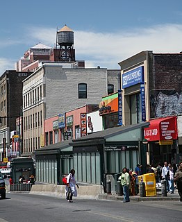
Koreatown, or K-Town, is an ethnic Korean enclave in Midtown Manhattan, New York City, centered on West 32nd Street between Madison Avenue and the intersection of Sixth Avenue and Broadway, which is known as Greeley Square. The neighborhood in Midtown South features over 150 businesses of various types and sizes, ranging from small restaurants and beauty salons to large branches of Korean banking conglomerates. Koreatown, Manhattan has become described as the "Korean Times Square" and has emerged as the international economic outpost for the Korean chaebol.

The Delaware Valley is the valley through which the Delaware River flows. By extension, this toponym is commonly used to refer to Greater Philadelphia or Philadelphia metropolitan area, which straddles the Lower Delaware River just north of its estuary. The Delaware Valley Metropolitan Area is located at the southern part of the Northeast megalopolis and as such, the Delaware Valley can be described as either a metropolitan statistical area (MSA), or as a broader combined statistical area (CSA). The Delaware Valley Metropolitan Area is composed of several counties in southeastern Pennsylvania and southwestern New Jersey, one county in northern Delaware, and one county in northeastern Maryland. The MSA has a population of over 6 million, while the CSA has a population of over 7.1 million. Philadelphia, being the region's major commercial, cultural, and industrial center, wields a rather large sphere of influence that affects the counties that immediately surround it.

Cheltenham is an unincorporated community in Cheltenham Township, Montgomery County, Pennsylvania, United States, with a ZIP code of 19012. It located directly over the city line of Philadelphia. It also borders Northeast Philadelphia over the Fox Chase Line on the east and over Cottman Avenue on the north side.

Fern Rock is a neighborhood in the upper North Philadelphia section of Philadelphia, Pennsylvania bounded by Olney to the east, Ogontz to the west, Logan to the south, and East Oak Lane to the north. It is approximately situated between Broad Street, Tabor Road, 7th Street, Godfrey Avenue and Fisher Park. Fern Rock borders Ogontz at Broad Street, Logan at Olney Avenue, East Oak Lane at Godfrey Avenue, and Olney at the train tracks.

North Philadelphia, nicknamed North Philly, is a section of Philadelphia, Pennsylvania, in the United States. It is immediately north of Center City. Though the full extent of the region is somewhat vague, "North Philadelphia" is regarded as everything north of either Vine Street or Spring Garden Street, between Northwest Philadelphia and Northeast Philadelphia. It is bordered to the north by Cheltenham Township along Cheltenham Avenue, Spring Garden Street to the south, 35th Street to the west, and Adams Avenue to the east. The Philadelphia Police Department patrols five districts located within North Philadelphia: the 22nd, 25th, 26th, 35th, and 39th districts. There are seven ZIP codes for North Philadelphia: 19132, 19133, 19121, 19122, 19130, 19123 and 19120

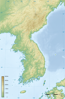
Frankford Creek is a minor tributary of the Delaware River in southeast Pennsylvania. It derived its name from the nearby town of Frankford, Philadelphia County. The stream originates as Tookany Creek at Hill Crest in Cheltenham Township and meanders eastward, then southeastward, throughout Cheltenham Township, until a sharp bend near the Philadelphia border at Lawncrest, where the place names Toxony and Tookany were used in historic times; the stream is still known as Tookany Creek in this region, where it flows southwest. Turning south into Philadelphia at the crotch of Philadelphia's Y-shaped border, the creek is called Tacony Creek; from here southward, it is considered the informal boundary separating Northeast Philadelphia from the rest of the city. The Philadelphia neighborhoods of Olney and Feltonville lie on the western side of the stream in this area while Northwood, Lawncrest, Summerdale, and Frankford lie on the eastern side. It continues to be called the Tacony at least until the smaller Wingohocking Creek merges with it in Juniata Park, within the city-owned golf course. Beyond Castor Avenue it is known as Frankford Creek until the stream's confluence with the Delaware River in the Bridesburg neighborhood of Philadelphia, Pennsylvania. The section of stream known as Frankford Creek is 3.1 miles (5.0 km) long, and the upstream section known as Tacony Creek, from Hill Crest, is 11.1 miles (17.9 km) long.
Logan is a neighborhood in the upper North Philadelphia section of the city of Philadelphia, in the U.S. state of Pennsylvania. Majority of the neighborhood falls within the 19141 zip code, but some of it falls within 19140. The neighborhood is sometimes confused with the Olney neighborhood of Philadelphia. Olney Avenue extends from both the Olney and Logan neighborhoods of the city. The Olney Transportation Center is located in Logan.

Bristol Township is a defunct township that was located in Philadelphia County, Pennsylvania. The township ceased to exist and was incorporated into the City of Philadelphia following the passage of the Act of Consolidation, 1854. It is the modern day Olney-Oak Lane Planning Analysis Section, though with a slight difference in the southern border. It is in present-day North Philadelphia, although Olney-Oak Lane is sometimes considered to be separate from North Philadelphia entirely because of their unique architecture, culture and differing patterns of development.
Cherry Hill is a township in Camden County, New Jersey, United States. As of the 2010 United States Census, the township had a population of 71,045, reflecting an increase of 1,080 (+1.5%) from the 69,965 counted in the 2000 Census, which had in turn increased by 617 (+0.9%) from the 69,348 counted in the 1990 Census. As of 2010, the township was the state's 15th most populous municipality and the second-largest in Camden County, after having been the state's 13th most populous municipality in the 2000 Census. An edge city of Philadelphia, Cherry Hill is situated on the Delaware Valley coastal plain, approximately 8 miles (13 km) southeast of Center City, Philadelphia.

Koreatown, Fort Lee, or Fort Lee Koreatown, in the borough of Fort Lee, Bergen County, New Jersey, United States, in the New York City Metropolitan Area, is one of the largest and fastest growing ethnic Korean enclaves outside of Korea.
Koreatown, Long Island, or the Long Island Koreatown, on Long Island in the U.S. state of New York, is one of the largest and fastest growing ethnic Korean enclaves outside Korea.
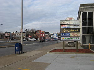
Olney-Oak Lane, Philadelphia, is a section of Philadelphia that is immediately north of Upper North Philadelphia and south of Cheltenham. It is an area that consists of the now defunct township that was called "Bristol Township, Philadelphia County, Pennsylvania". The section is often included as part of North Philadelphia by city government agencies, though locally it is often referred to as "Uptown," along with the Germantown section.
Philadelphia has the second largest Puerto Rican community outside of Puerto Rico. As of the 2010 U.S. Census, an estimated 121,643 Puerto Ricans were living in Philadelphia, up from 91,527 in 2000. Recent 2017 estimates by the U.S. Census Bureau put the number of Puerto Ricans living in Philadelphia at 134,934. Many Puerto Ricans in the Philadelphia area have engaged in circular migration in which they spend periods of time living in Philadelphia and periods of time living in Puerto Rico.

Cheltenham Township is a home rule township bordering North Philadelphia in Montgomery County, Pennsylvania, United States. Cheltenham's population density ranges from over 10,000 per square mile in rowhouses and high-rise apartments along Cheltenham Avenue to historic neighborhoods in Wyncote and Elkins Park. It is the most densely populated township in Montgomery County. The population was 36,793 at the 2010 U.S. Census, making it the third most populous township in Montgomery County and the 27th most populous municipality in Pennsylvania. It was originally part of Philadelphia County, and it became part of Montgomery County upon that county's creation in 1784.