Related Research Articles
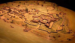
Fort Duquesne was a fort established by the French in 1754, at the confluence of the Allegheny and Monongahela rivers. It was later taken over by the British, and later the Americans, and developed as Pittsburgh in the U.S. state of Pennsylvania. Fort Duquesne was destroyed by the French before its British conquest during the Seven Years' War, known as the French and Indian War on the North American front. The British replaced it, building Fort Pitt between 1759 and 1761. The site of both forts is now occupied by Point State Park, where the outlines of the two forts have been laid in granite slabs.

A parkway is a landscaped thoroughfare. The term is particularly used for a roadway in a park or connecting to a park from which trucks and other heavy vehicles are excluded.
Grandview or Grand View may refer to:

The Lewis and Clark National Historic Trail is a route across the United States commemorating the Lewis and Clark Expedition of 1804 to 1806. It is part of the National Trails System of the United States. It extends for some 4,900 miles (7,900 km) from Pittsburgh, Pennsylvania, to the mouth of the Columbia River in Oregon.

Little Beaver Creek is a wild and scenic area in Ohio. The Little Beaver Creek watershed is located primarily in Columbiana County in eastern Ohio, and in portions of Carroll County, Mahoning County, and western Pennsylvania, draining approximately 605 mi² (1,567 km²), of which 503 mi² (1,303 km²) are in Ohio. The watershed in total size covers an area of approximately 510 square miles, with about 80% of this being situated in Ohio. The great majority of land within the watershed is privately owned. Within the watershed are roughly 808 miles of linear streams.
Centerville, also known as Centreville, is an unincorporated community in New Castle County, Delaware, United States. Centerville is now known primarily for being the location of Du Pont family estates, as well as several other wealthy business families from nearby Wilmington, and the home of Governor Jack Markell.
Point of View or Points of View may refer to:

The Great Lakes Seaway Trail, formerly named and commonly known as the Seaway Trail, is a 518-mile (834 km) National Scenic Byway in the northeastern United States, mostly contained in New York but with a small segment in Pennsylvania. The trail consists of a series of designated roads and highways that travel along the Saint Lawrence Seaway—specifically, Lake Erie, the Niagara River, Lake Ontario, and the Saint Lawrence River. It begins at the Ohio state line in rural Erie County, Pennsylvania, and travels through several cities and villages before ending at the Seaway International Bridge northeast of the village of Massena in St. Lawrence County, New York. It is maintained by the non-profit Seaway Trail, Inc.
The West End-Elliott Overlook Park, often shortened to West End Overlook, is a small municipal park and scenic viewpoint in the Elliott neighborhood of Pittsburgh, Pennsylvania.

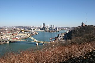
Emerald View Park is a large municipal park in Pittsburgh, Pennsylvania. It encircles the neighborhoods of Mt. Washington, Duquesne Heights and Allentown and offers scenic views of the city that draw more than 1.5 million visitors annually.
Point of View is a 2006 landmark public sculpture in bronze by James A. West which sits in a parklet named for the work of art, Point of View Park, in Pittsburgh, Pennsylvania United States. The piece depicts George Washington and the Seneca leader Guyasuta, with their weapons down, in a face-to-face meeting in October 1770, when the two men met while Washington was in the area examining land for future settlement along the Ohio River.
The Trail Ridge Road/Beaver Meadow National Scenic Byway is a 55-mile (89 km) All-American Road and Colorado Scenic and Historic Byway located in Rocky Mountain National Park in Larimer and Grand counties, Colorado, USA. The byway consists of the 48-mile (77 km) Trail Ridge Road and the connecting 6.9-mile (11 km) Beaver Meadow Road. With a high point at 12,183 feet (3,713 m) elevation, Trail Ridge Road is the highest continuous paved road in North America. The higher portion of Trail Ridge Road is closed from October to May. The Rocky Mountain National Park Administration Building is a National Historic Landmark.

The Dinosaur Diamond is a 486-mile (782 km) scenic and historic byway loop through the dinosaur fossil laden Uinta Basin of the U.S. states of Utah and Colorado. The byway comprises the following two National Scenic Byways:
The Flaming Gorge - Uintas Scenic Byway is a National Scenic Byway in the state of Utah. It spans approximately 80 miles (130 km) as it travels from Vernal, Utah northward through the Ashley National Forest and the Uintah Mountains to the area around Flaming Gorge National Recreation Area in the northeastern corner of the state.
The Cache la Poudre-North Park Scenic Byway is a 101-mile (163 km) National Forest Scenic Byway and Colorado Scenic and Historic Byway located in Jackson and Larimer counties, Colorado, US.
The Colorado River Headwaters National Scenic Byway is an 80-mile (129 km) National Scenic Byway and Colorado Scenic and Historic Byway located in Eagle and Grand counties, Colorado, US. The byway follows the upper Colorado River from Grand Lake down to State Bridge. The byway connects with the Trail Ridge Road/Beaver Meadow National Scenic Byway at Grand Lake.
References
- 1 2 Diana Nelson Jones (2006), Point of View sculpture installation: story from the Pittsburgh Post-Gazette. Retrieved May 12, 2007.
- ↑ "Remarks & Occurrs. in October 1770," Founders Online, National Archives. The Diaries of George Washington, vol. 2, 14 January 1766 – 31 December 1770, ed. Donald Jackson. Charlottesville: University Press of Virginia, 1976, pp. 286–307.