
Mt. Lebanon is a township with home rule status in Allegheny County, Pennsylvania, United States. The population was 34,075 at the 2020 census. It is a suburb of Pittsburgh. Established in 1912 as Mount Lebanon, the township was a farming community. With the arrival of the first streetcar lines and the development of the first real estate subdivision, both in 1901, it became a streetcar suburb, offering residents the ability to commute to Downtown Pittsburgh. Further, the opening of the Liberty Tunnel in 1924 allowed easy automobile access to Pittsburgh. In 1975, the renamed Mt. Lebanon adopted one of the first home rule charters in Pennsylvania.
Grandview or Grand View may refer to:

Hazelwood is a neighborhood of Pittsburgh, Pennsylvania in the United States. It is represented on Pittsburgh City Council by Corey O'Connor. It is bordered by Greenfield and Oakland on the north, Squirrel Hill and Glen Hazel on the east, and the Monongahela River on the south and west. The Pittsburgh Bureau of Fire houses 13 Engine and 13 Truck in Hazelwood.
The Spring Mountains National Recreation Area (SMNRA) is a U.S. national recreation area, administered by the U.S. Forest Service, west of Las Vegas, Nevada. It covers over 316,000 acres. The area runs from low meadows, to the 11,918-foot (3,633 m) Mount Charleston. The SMNRA is a part of the Humboldt-Toiyabe National Forest. It adjoins the Red Rock Canyon National Conservation Area, which is administered by the Bureau of Land Management.

The Grand Rounds National Scenic Byway is a linked series of park areas in Minneapolis, Minnesota, United States, that takes a roughly circular path through the city. The Minneapolis Park and Recreation Board developed the system over many years. The corridors include roads for automobile traffic plus separate paths for pedestrians and bicycles, and extend slightly into neighboring cities. About 50 miles (80 km) of roadway and paths are in the system, and much of it was built in the 1930s as part of Civilian Conservation Corps projects.

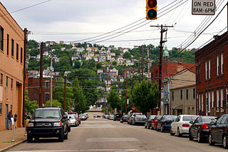
Duquesne Heights is a neighborhood in Pittsburgh, Pennsylvania's south city area. It has a zip code of 15211, and has representation on Pittsburgh City Council by the council member for District 2.

Lawrenceville is one of the largest neighborhood areas in Pittsburgh in the U.S. state of Pennsylvania. It is located northeast of downtown, and like many of the city's riverfront neighborhoods, it has an industrial past. The city considers Lawrenceville three neighborhoods, Upper Lawrenceville, Central Lawrenceville, and Lower Lawrenceville, but these distinctions have little practical effect. Accordingly, Lawrenceville is almost universally treated as being a single large neighborhood.

A greenway is usually a shared-use path along a strip of undeveloped land, in an urban or rural area, set aside for recreational use or environmental protection. Greenways are frequently created out of disused railways, canal towpaths, utility or similar rights of way, or derelict industrial land. Greenways also can also be linear parks, and can serve as wildlife corridors. The path's surface may be paved and often serves multiple users: walkers, runners, bicyclists, skaters and hikers. A characteristic of greenways, as defined by the European Greenways Association, is "ease of passage": that is that they have "either low or zero gradient", so that they can be used by all "types of users, including mobility impaired people".

The Red Line is a line on the Pittsburgh Light Rail system that runs between South Hills Village and Downtown Pittsburgh via the Beechview neighborhood. The companion route, the Blue Line, branches off north of Martin Villa – which closed in 2012 – and runs through Overbrook. In March 2007, the closure of the Palm Garden Bridge for refurbishment suspended the Red Line for five months; it resumed service in September.
South Side Slopes is a neighborhood in Pittsburgh, Pennsylvania's South Side area. The neighborhood comprises the hills from the South Side Flats neighborhood along the Monongahela River from the Liberty Bridge (west) to beyond Josephine Street (east).

Point of View Park is a parklet in Pittsburgh, Pennsylvania.
Point of View is a 2006 landmark public sculpture in bronze by James A. West; it sits in a parklet named for the work of art, Point of View Park, in Pittsburgh, Pennsylvania.
A linear park is a type of park that is significantly longer than it is wide. These linear parks are strips of public land running along canals, rivers, streams, defensive walls, electrical lines, or highways and shorelines. Examples of linear parks include everything from wildlife corridors to riverways to trails, capturing the broadest sense of the word. Other examples include rail trails, which are disused railroad beds converted for recreational use by removing existing structures. Commonly, these linear parks result from the public and private sectors acting on the dense urban need for open green space. Linear parks stretch through urban areas, coming through as a solution for the lack of space and need for urban greenery. They also effectively connect different neighborhoods in dense urban areas as a result, and create places that are ideal for activities such as jogging or walking. Linear parks may also be categorized as greenways. In Australia, a linear park along the coast is known as a foreshoreway. When being designed, linear parks appear unique as they are planned around the public's opinion of how the space will affect them.

Waite Park is a neighborhood in the Northeast community in Minneapolis, Minnesota. It's boundaries are 37th Avenue NE to the north, NE Stinson Boulevard to the East, Saint Anthony Parkway to the south, and NE Central Avenue to the west. It is the furthest northeast neighborhood within Minneapolis. The neighborhood is within Minneapolis's first ward and falls under the jurisdiction of the second precinct of the Minneapolis Police Department.

Summerset at Frick Park is a residential development located in the Squirrel Hill and Swisshelm Park neighborhoods within the City of Pittsburgh and Allegheny County. This project is one of the nation's first brownfield sites to be remediated for residential purposes. The $250 million public-project began in 1997 and is the City of Pittsburgh's largest residential development since World War II. At completion, Summerset at Frick Park will have over 700 residences and its annual property tax revenue is anticipated to be in the range of $5.7 million to $6.3 million.


