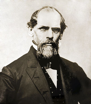
John Augustus Roebling was a German-born American civil engineer. He designed and built wire rope suspension bridges, in particular the Brooklyn Bridge, which has been designated as a National Historic Landmark and a National Historic Civil Engineering Landmark.

Downtown Pittsburgh, colloquially referred to as the Golden Triangle, and officially the Central Business District, is the urban downtown center of Pittsburgh, Pennsylvania, United States. It is located at the confluence of the Allegheny River and the Monongahela River whose joining forms the Ohio River. The triangle is bounded by the two rivers.

The Roberto Clemente Bridge, also known as the Sixth Street Bridge, spans the Allegheny River in downtown Pittsburgh, Pennsylvania, United States.

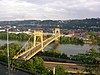
The Smithfield Street Bridge is a lenticular truss bridge crossing the Monongahela River in Pittsburgh, Pennsylvania, USA.

Lawrenceville is one of the largest neighborhood areas in Pittsburgh in the U.S. state of Pennsylvania. It is located northeast of downtown, and like many of the city's riverfront neighborhoods, it has an industrial past. The city officially divides Lawrenceville into three neighborhoods, Upper Lawrenceville, Central Lawrenceville, and Lower Lawrenceville, but these distinctions have little practical effect. Accordingly, Lawrenceville is almost universally treated as a single large neighborhood.

Troy Hill is a neighborhood on Pittsburgh, Pennsylvania's North Side. It has a zip code of 15212, and has representation on Pittsburgh City Council by the council member for District 1.

The Coraopolis Bridge[1] is a girder bridge over the back channel of the Ohio River connecting Grand Avenue on Neville Island to Ferree Street in Coraopolis, Pennsylvania. It opened in 1995 to replace a structure of historic significance. The original Pratt/Bowstring/Pennsylvania[2] through truss spans, designed by Theodore Cooper, were formerly the (third) Sixth Street Bridge, spanning the Allegheny River, in downtown Pittsburgh, and were built in 1892 by the Union Bridge Company. They were floated downstream by the Foundation Company in 1927 rather than being demolished when the bridge was removed to enable construction of the present (fourth) Three Sisters (Pittsburgh) Sixth Street Self-anchored suspension bridge. However, by the late 1980s, the old bridge could no longer support traffic volumes and was replaced by a newer structure.

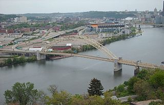
The Birmingham Bridge is a bowstring arch bridge that is located in Pittsburgh, Pennsylvania and spans the Monongahela River.
The West End Bridge is a steel tied-arch bridge over the Ohio River in Pittsburgh, Pennsylvania, approximately 1 mile (1.6 km) below the confluence of the Allegheny and Monongahela Rivers. It connects the West End to the Chateau neighborhood on the North Side of Pittsburgh.

Andy Warhol Bridge, also known as the Seventh Street Bridge, spans the Allegheny River in Downtown Pittsburgh. It is the only bridge in the United States named for a visual artist. It was opened at a cost of $1.5 million on June 17, 1926, in a ceremony attended by 2,000.

A large metropolitan area that is surrounded by rivers and hills, Pittsburgh has an infrastructure system that has been built out over the years to include roads, tunnels, bridges, railroads, inclines, bike paths, and stairways; however, the hills and rivers still form many barriers to transportation within the city.

Schenley Tunnel is a railroad tunnel in Pittsburgh, Pennsylvania, United States. The tunnel runs beneath Neville Street in the city's North Oakland neighborhood; the south portal is at the upper end of Junction Hollow emerging from under Filmore St., the north emerges from under Centre Ave. into a ravine that opens into Skunk Hollow, between North Oakland and Bloomfield.

The 33rd Street Railroad Bridge is a truss bridge that carries the Allegheny Valley Railroad on the P&W Subdivision over the Allegheny River that connects downtown Pittsburgh, Pennsylvania to Herrs Island, Pittsburgh, United States.

The Herr's Island Railroad Bridge, also known as the West Penn Railroad Bridge, is a truss bridge across the Allegheny River in the United States between the Pittsburgh neighborhoods of Troy Hill and Herrs Island.
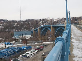
The William Raymond Prom Memorial Bridge, commonly known as the 31st Street Bridge, is an arch bridge that carries vehicular traffic across the Allegheny River between the Pittsburgh neighborhoods of Troy Hill and the Strip District. The bridge passes over but does not serve Washington's Landing, which is connected to the mainland by the 30th Street Bridge. Sidewalks along the bridge feature viewing platforms.

The Washington Crossing Bridge, commonly known as the Fortieth Street Bridge, is an arch bridge that carries vehicular traffic across the Allegheny River between the Pittsburgh neighborhood of Lawrenceville and the suburb of Millvale. The bridge is decorated with the seals representing the original 13 colonies of the US and that of Allegheny county.

The Senator Robert D. Fleming Bridge, commonly known as the 62nd Street Bridge, is a truss bridge that carries Pennsylvania Route 8 across the Allegheny River between the Pittsburgh neighborhoods of Morningside and Lawrenceville and Sharpsburg, Pennsylvania.

The Highland Park Bridge is a truss bridge that carries vehicular traffic across the Allegheny River between the Pittsburgh neighborhood of Highland Park and the suburb of Aspinwall.

The Point Bridge was a steel cantilever truss bridge that spanned the Monongahela River in Pittsburgh, Pennsylvania.