Greenfield Bridge

Last updated
Greenfield Bridge
Greenfield Bridge 2019.jpeg
The new Greenfield Bridge from the south
Coordinates 40°25′42″N79°56′17″W / 40.4282°N 79.9380°W / 40.4282; -79.9380
Crosses Four Mile Run, Interstate 376
Official nameBeechwood Boulevard (Greenfield) Bridge II
Characteristics
MaterialSteel
Total length462 feet (141 m) [1]
Width54.83 feet (16.71 m) [1]
Longest span287 feet (87 m) [2]
History
Engineering design by HDR, Inc.
Construction cost$17.5 million
OpenedOctober 15, 2017
Location
Greenfield Bridge

The Greenfield Bridge, officially known as the Beechwood Boulevard (Greenfield) Bridge II, is a steel arch bridge located in Pittsburgh, Pennsylvania, United States. [3] The bridge connects the neighborhoods of Greenfield and Squirrel Hill (specifically Schenley Park) [4] across the valley known as Four Mile Run which separates them. The bridge also spans the Parkway East (I-376), which runs along the bottom of the valley.

Contents

The current steel bridge is the third bridge at this location. The original wooden bridge was built in 1891 and collapsed in 1921. This was replaced by a concrete arch bridge which was completed in 1923 and demolished in 2015 after falling into disrepair.

First bridge

The original Greenfield Bridge in 1911 Greenfield Avenue Bridge 1911 (715.111885.CP).jpg
The original Greenfield Bridge in 1911

The original crossing at the site was a wooden deck truss bridge built in 1891, which was usually referred to as the Forward Avenue Bridge. [5] [6] [7] It was about 378 feet (115 m) long and 30 feet (9.1 m) wide. [8] In 1898, it became the southern terminus of the newly built Beechwood Boulevard, a 9-mile (14 km) carriageway following a circuitous route from Schenley Park north to Highland Park. [9] Afterwards, the bridge was also known as the Beechwood Boulevard Bridge.

The bridge had serious structural problems and was repaired several times before finally collapsing on June 18, 1921. At the time of the collapse, the bridge had been closed to vehicular traffic for more than a year but was still used by pedestrians. No one was hurt in the disaster, which occurred at about 2:40 on a Saturday afternoon, though five people who had either just crossed the bridge or were about to cross narrowly escaped. [8]

Second bridge

The collapsed wooden bridge was replaced with an open-spandrel concrete arch bridge which was constructed in 1921–1923. [10] It was completed by December 1922, but some of the approaches still needed to be filled in. The final cost was $370,000. [11] This bridge was officially named the Beechwood Boulevard Bridge, but was generally referred to as the Greenfield Bridge. [1] The bridge was 466 feet (142 m) in total length with a 274 foot (84 m) main span. [10] It was designed by chief engineer Charles M. Reppert and architect Stanley L. Roush and featured decorative elements including ornamental entrance pylons, light standards, and urns. The City of Pittsburgh built six other similar bridges in the 1910s and 1920s, of which only the Larimer Avenue Bridge survives as of 2022. [12]

The second bridge during construction in 1922 715.226518.CP.jpg
The second bridge during construction in 1922

By the 1970s, the bridge had begun to decay. Chunks of concrete fell from the bridge in 1970, necessitating a temporary closure for repairs. [13] In 1980–81, the bridge received a $2.1 million rehabilitation including repairs to the concrete structure and a new deck. [14] During this project, most of the decorative elements on the bridge deck were removed. [12] Chunks of concrete again fell from the bridge in 1990, prompting the city to install safety netting. Despite the netting, more concrete fell a few days later, causing at least 20 accidents on the Parkway East and injuring several people. A city engineer said he suspected vandals may have thrown the concrete, though spotters watching the bridge did not see anyone. [15]

The second bridge in 2012, showing the safety netting and 'bridge under a bridge' added to protect vehicles from falling debris Interstate 376 - Pennsylvania (8461456052) (2).jpg
The second bridge in 2012, showing the safety netting and 'bridge under a bridge' added to protect vehicles from falling debris

A driver was injured by another piece of falling concrete under the Greenfield Bridge in 2003. An inspection concluded this fragment was not a piece of the bridge, [16] but the city nevertheless constructed a 'bridge under a bridge' to protect the roadway from any additional falling debris. [17] [18] The decrepit condition of the bridge became "a national symbol of infrastructure failure" in the United States, and its poor condition was featured on 60 Minutes , Last Week Tonight with John Oliver , and (more light-heartedly) Pittsburgh Dad . [19] [20]

The bridge was imploded on December 28, 2015 at 9:20 am. [21] The inbound side of I-376 reopened to traffic on the 31st, a day ahead of schedule. However, the outbound side suffered damage despite a protective layer of dirt placed under the bridge for the implosion and its reopening was delayed. [22]

Current bridge

The replacement bridge opened to traffic on October 15, 2017. It is officially known as the Beechwood Boulevard (Greenfield) Bridge II. [23] The new bridge cost $17.5 million to construct and was designed and engineered by HDR, Inc. [2]

The new bridge mimics the appearance of the original structure and many of the stone ornaments from the original bridge were restored and incorporated into it. [2] The new bridge has wider lanes and sidewalks and a dedicated bicycle path. [2] Its steel elements are painted green to reflect its connection to the community of Greenfield. [2]

Related Research Articles

<span class="mw-page-title-main">Robert F. Kennedy Bridge</span> Bridges connecting Manhattan, Queens, and the Bronx, New York

The Robert F. Kennedy Bridge is a complex of bridges and elevated expressway viaducts in New York City. The bridges link the boroughs of Manhattan, Queens, and the Bronx. The viaducts cross Randalls and Wards Islands, previously two islands and now joined by landfill.

<span class="mw-page-title-main">Squirrel Hill</span> Neighborhood of Pittsburgh in Allegheny County, Pennsylvania, United States

Squirrel Hill is a residential neighborhood in the East End of Pittsburgh, Pennsylvania, United States. The city officially divides it into two neighborhoods, Squirrel Hill North and Squirrel Hill South, but it is almost universally treated as a single neighborhood.

<span class="mw-page-title-main">Greenfield (Pittsburgh)</span> Neighborhood of Pittsburgh in Allegheny County, Pennsylvania, United States

Greenfield is a neighborhood in Pittsburgh, Pennsylvania, United States. It is represented on Pittsburgh City Council by Barb Warwick.

<span class="mw-page-title-main">Bronx–Whitestone Bridge</span> Bridge between Queens and the Bronx, New York

The Bronx–Whitestone Bridge is a suspension bridge in New York City, carrying six lanes of Interstate 678 over the East River. The bridge connects Throggs Neck and Ferry Point Park in the Bronx, on the East River's northern shore, with the Whitestone neighborhood of Queens on the southern shore.

<span class="mw-page-title-main">South Tenth Street Bridge</span> Bridge in Pittsburgh, Pennsylvania

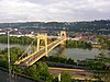
The South Tenth Street Bridge, most often called the Tenth Street Bridge, but officially dubbed the Philip Murray Bridge, is a suspension bridge that spans the Monongahela River in Downtown Pittsburgh, Pennsylvania.

<span class="mw-page-title-main">West End Bridge</span> Bridge in Pittsburgh, Pennsylvania

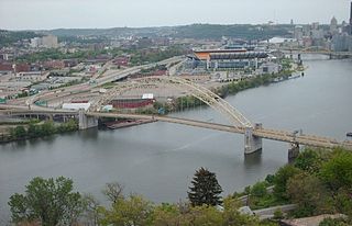
The West End Bridge is a steel tied-arch bridge over the Ohio River in Pittsburgh, Pennsylvania, approximately 1 mile (1.6 km) below the confluence of the Allegheny and Monongahela Rivers. It connects the West End to the Chateau neighborhood on the North Side of Pittsburgh.

<span class="mw-page-title-main">Transportation in Pittsburgh</span> Transportation in Pittsburgh, Pennsylvania, United States

Transportation in Pittsburgh, Pennsylvania is different than in many other major American cities. A large metropolitan area that is surrounded by rivers and hills, Pittsburgh has an infrastructure system that has been built out over the years to include roads, tunnels, bridges, railroads, inclines, bike paths, and stairways; however, the hills and rivers still form many barriers to transportation within the city.

<span class="mw-page-title-main">Boulevard of the Allies</span> Major road in Pittsburgh, US

The Boulevard of the Allies is a mostly four-lane road in the U.S. state of Pennsylvania, connecting Downtown Pittsburgh with the Oakland neighborhood of the city. Because of its lengthy name, locals sometimes refer to it as simply "The Boulevard".

<span class="mw-page-title-main">Pennsylvania Route 885</span> State highway in Allegheny County, Pennsylvania, US

Pennsylvania Route 885 is a 14.1 mi (22.69 km) long north–south state highway in the U.S. state of Pennsylvania. It runs from Pennsylvania Route 837 in Clairton north to Interstate 579 in Pittsburgh. The route is entirely within Allegheny County and serves as a connector between the city of Pittsburgh and its southern suburbs.

<span class="mw-page-title-main">Schenley Plaza</span>

<span class="mw-page-title-main">Schenley Tunnel</span>

Schenley Tunnel is a railroad tunnel in Pittsburgh, Pennsylvania, United States. The tunnel runs beneath Neville Street in the city's North Oakland neighborhood; the south portal is at the upper end of Junction Hollow emerging from under Filmore St., the north emerges from under Centre Ave. into a ravine that opens into Skunk Hollow, between North Oakland and Bloomfield.

<span class="mw-page-title-main">Schenley Bridge</span> Bridge in Pittsburgh, Pennsylvania

The Schenley Bridge is a steel three-hinged deck arch bridge spanning Junction Hollow in Pittsburgh, Pennsylvania. It carries Schenley Drive between Oakland on the west and the main part of Schenley Park on the east, connecting Schenley Plaza, the Carnegie Institute, and the Frick Fine Arts Building with Frew Street, Flagstaff Hill, and Phipps Conservatory. The bridge spans 620 feet (190 m) and arches 120 feet (37 m) above the hollow.

<span class="mw-page-title-main">Panther Hollow Bridge</span> Bridge in Pittsburgh, Pennsylvania

The Panther Hollow Bridge is an American steel, three-hinged, deck arch bridge that carries Panther Hollow Road over Panther Hollow in Schenley Park in Pittsburgh, Pennsylvania.

<span class="mw-page-title-main">Forbes Avenue</span>

Forbes Avenue is one of the longest streets in Pittsburgh, Pennsylvania, United States. It runs along an east–west route for a length of approximately 7 mi (11 km).

<span class="mw-page-title-main">Bloomfield Bridge</span> Bridge in Pittsburgh, Pennsylvania, US

The Bloomfield Bridge is a bridge in Pittsburgh, Pennsylvania, which carries four lanes of traffic across Skunk Hollow, a steep ravine between the densely populated neighborhoods of Bloomfield and Polish Hill.

<span class="mw-page-title-main">Panther Hollow Lake</span> Lake in Pittsburgh, Pennsylvania

Panther Hollow Lake is a human-made lake in Schenley Park in Pittsburgh, Pennsylvania.

The Fern Hollow Bridge is the name used for one of a series of three bridges in the East End of Pittsburgh, Pennsylvania, United States; each bridge carried Forbes Avenue over a large ravine in Frick Park. The first Fern Hollow Bridge opened in 1901 as a steel deck arch, and was demolished in 1972 while the second bridge was being built. The second bridge opened in 1973 and collapsed on January 28, 2022. Construction of the third bridge began on May 9, 2022, and the third bridge was dedicated on December 20, 2022.

<span class="mw-page-title-main">Charles Anderson Memorial Bridge</span> Bridge in Pittsburgh

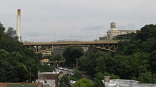
The Charles Anderson Memorial Bridge is a steel deck truss bridge located in Pittsburgh, Pennsylvania, United States. The bridge carries the four-lane roadway of Boulevard of the Allies across a ravine known as Junction Hollow, connecting the neighborhoods of Central Oakland and South Oakland with Schenley Park. The bridge also spans the Junction Hollow Trail and P&W Subdivision railroad tracks which run along the bottom of the valley.

<span class="mw-page-title-main">Swindell Bridge</span> Bridge in Pittsburgh

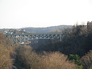
The E. H. Swindell Bridge is a steel deck truss cantilever bridge located in Pittsburgh, Pennsylvania, United States. The bridge connects the adjoining hilltop neighborhoods of Perry South, Spring Hill–City View, and Northview Heights on the city's North Side. It spans a ravine known as East Street Valley or Butcher's Run which was formerly a residential neighborhood but is now occupied by Interstate 279.

References

  1. 1 2 3 "Award-Winning Greenfield Bridge Built for the Future while Embracing the Past" (PDF). High Steel News. High Steel Structures. Spring 2018. pp. 1, 3–4. Retrieved 12 June 2019.
  2. 1 2 3 4 5 "Best Highway/Bridges: Beechwood Boulevard (Greenfield) Bridge Replacement". ENR. BNP Media. 16 October 2018. Retrieved 12 June 2019.
  3. "Beechwood Boulevard (Greenfield) Bridge to be Replaced". February 2013.
  4. "Pittsburgh Neighborhoods Map". City of Pittsburgh. Retrieved February 2, 2022.
  5. "Ready To Be Opened". Pittsburgh Press. November 7, 1891. Retrieved February 10, 2022 via Newspapers.com.
  6. "The Contract Let". Pittsburgh Dispatch. December 2, 1891. Retrieved February 10, 2022 via Newspapers.com.
  7. "It Is Almost Completed". Pittsburgh Press. December 13, 1891. Retrieved February 10, 2022 via Newspapers.com.
  8. 1 2 "Greenfield High Bridge Crashes to Ground". Pittsburgh Post. June 19, 1921. Retrieved February 2, 2022 via Newspapers.com.
  9. "Boulevard Opened". Pittsburg Press. January 3, 1899. Retrieved February 7, 2022 via Newspapers.com.
  10. 1 2 "Greenfield Bridge Project - Pittsburgh, PA".
  11. Pittsburgh Post-Gazette, "Boulevard Bridge To Be Opened to the Public This Month", December 9, 1922; page 1.
  12. 1 2 "Beechwood Boulevard (Greenfield) Bridge to Be Replaced". Pittsburgh History & Landmarks Foundation. February 1, 2013. Retrieved February 7, 2022.
  13. "Greenfield Span Closed Again". Pittsburgh Post-Gazette. June 2, 1970. Retrieved February 7, 2022 via Newspapers.com.
  14. "Span To Open In Greenfield". Pittsburgh Press. June 6, 1981. Retrieved February 7, 2022 via Newspapers.com.
  15. Kane, Mary (June 4, 1990). "Falling chunks cause mayhem on Parkway East". Pittsburgh Press. Clippings of the first and second pages via Newspapers.com. Accessed February 7, 2022.
  16. Pro, Johnna A. (February 7, 2003). "Bridge over parkway to get earlier look". Pittsburgh Post-Gazette. Retrieved February 7, 2022 via Newspapers.com.
  17. Grata, Joe (June 11, 2003). "Debris-catching span to precede bridge work". Pittsburgh Post-Gazette. Retrieved February 7, 2022 via Newspapers.com.
  18. Potter, Chris (September 1, 2005). "Shortly after passing through the Squirrel Hill Tunnel, you pass underneath the Greenfield Bridge, and also a second bridge underneath it. What is this strange bridge that doesn't lead from or to anywhere?". Pittsburgh City Paper. Retrieved February 7, 2022.
  19. Melissa Daniels, Greenfield Bridge, symbol of infrastructure decay, to be built anew, Pittsburgh Tribune-Review (October 10, 2015).
  20. "Dad Flips Out in Traffic". YouTube .
  21. "After nearly a century, 'grand' old Greenfield Bridge makes way for the new". Pittsburgh Post-Gazette.
  22. "Parkway East reopens ahead of schedule after Greenfield Bridge..." WPXI. Archived from the original on 2016-01-02. Retrieved 2015-12-31.
  23. Clift, Theresa (October 14, 2017). "New bridge restores identity for Pittsburgh's Greenfield neighborhood". Pittsburgh Tribune-Review. Retrieved January 30, 2018.