Conceived in the late 1800s, the tunnel was built in 1903 for Gould's Wabash Pittsburgh Terminal Railway venture into Pittsburgh, which failed financially in 1908.[1][2] It carried passenger trains into the city until 1931, and freight trains until 1946.[1][3][4] After the end of train service, the tunnel sat empty for many years. The tunnel was once connected to the Wabash Bridge across the Monongahela River, but the bridge was demolished in 1948,[2] and was not replaced. Its two stone support piers remain in the river.[1]
Conversion to a transitway
In the early 1970s Pittsburgh Regional Transit, then known as Port Authority, or PAT, spent US$6 million(US$45.1 million today) rebuilding the tunnel for the never-to-be-operational Skybuspeople mover system.[1][4] The project was also to include a new Monongahela River bridge.[3]
Use as a bus garage
During this period, the tunnel was used to hold up to 87 of PAT's disused 1950s-era transit buses in reserve.[5] The tunnel portals were reinforced to deter vandals, to the satisfaction of PAT's insurers.[5] Despite this, in 1980, vandals gained access and smashed hundreds of windows and headlights on the two rows of buses parked inside.[4]
Conversion to a roadway
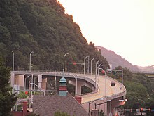
Carson Street rampAutomobile on ramp leading into tunnel
By 1992, the Pennsylvania Department of Transportation (PennDOT) was considering using the Wabash Tunnel as a roadway to compensate for an upcoming closure of the Fort Pitt Tunnel.[4][6] As part of the conversion to a roadway, the guideways for the Skybus system were removed and replaced with new paving and drainage.[4] When awarded in 1994, the contract for this work was worth US$3.2 million(US$6.6 million today).[1][4] However, in 1995, PAT declined to build a new road bridge (estimated at $US25.8 million, or US$51.6 million today) to connect the tunnel with downtown Pittsburgh.[4]
On July 23, 2003 PAT approved contracts for US$10.9 million(US$18.1 million today) to build high-occupancy vehicle (HOV) ramps and modernized the tunnel, as well as provide a 172-space park-and-ride lot along Woodruff Street.[7] The HOV lane was opened on December 27, 2004,[4] running from West Carson Street on the South Side and through the tunnel to Woodruff Street in Mt. Washington. The Fort Pitt Tunnel to the west and the Liberty Tunnels to the east carry nearly all of the vehicular traffic heading downtown.[citation needed]
On November 6, 2013 the Federal Transit Administration lifted the car pool requirements to provide an alternate route for drivers, due to the two-year closure of outbound West Carson Street.[8]
On February 24, 2017 PAT announced that the HOV restrictions had been waived permanently.[9]
Operators
December 2006 nighttime photo of the north end of the tunnel.
The tunnel was sold in 1931 to Allegheny County for US$3 million(US$60.1 million today).[4] The county intended to convert it to a road and use it to relieve the traffic congestion in the Liberty Tunnels, and in 1933 commissioned a $5000 study to investigate this concept.[4]
As of April2006[update], the tunnel was operated and maintained for PAT by Bruce & Merrilees, at an annual cost of $780,000.[3]
Incidents
The tunnel's north portal was severely damaged in a 1925 landslide.[4] The tunnel was temporarily closed due to fallen trees on July 19, 2012.[10]
1 2 Bennett, Joe (June 5, 1977), "Pittsburgh's Hard-Luck Bridge", The Pittsburgh Press Roto, Pittsburgh, PA, United States: Pittsburgh Press Co., OCLC2266185, archived from the original on October 3, 2009, A plan to use the bridge and tunnel as part of a mass transit system into the South Hills had been dropped. Somebody suggested taking the bridge down and putting it up elsewhere. Finally, the old bridge was scrapped and the steel melted down for use in the Dravosburg Bridge that was going up in 1948.
1 2 3 Grata, Joe (April 25, 2006), "Wabash Tunnel has become expensive venture", Pittsburgh Post-Gazette, Pittsburgh, PA, United States: Block Communications, ISSN1068-624X, OCLC44283479, archived from the original on 2011-06-29, retrieved September 26, 2012, The transit agency pays $780,000 a year to Bruce & Merrilees, a private company, to provide a supervisor and workers. They change gates and signs that control the alternating one-way flow of traffic, monitor closed-circuit video surveillance and carbon monoxide detection systems, respond to accidents, clear snow and handle breakdowns.
1 2 3 4 5 6 7 8 9 10 11 12 "Wabash Tunnel milestones", Pittsburgh Post-Gazette, Pittsburgh, PA, United States: Block Communications, December 26, 2004, ISSN1068-624X, OCLC44283479, archived from the original on 2012-09-29, retrieved September 29, 2012, The Wabash Tunnel will open for mixed use. That is, car and van pools of two or more people during rush hours, and for all vehicles during off-peak hours. The tunnel is one lane that will be reversed to accommodate traffic flow.
1 2 Grata, Joe (August 1, 1978), "PAT Storing Buses in Wabash Tunnel", Pittsburgh Post-Gazette, Pittsburgh, PA, United States: Block Communications, pp.A-1 & A-4, ISSN1068-624X, OCLC10846671, archived from the original on 2016-05-06, But now PAT has discovered another way to put the tunnel to use — as a parking garage for 87 old buses.
↑ "Downed trees close Wabash Tunnel", Pittsburgh Post-Gazette, Pittsburgh, PA, United States: Block Communications, July 19, 2012, ISSN1068-624X, OCLC44283479, archived from the original on 2012-09-20, retrieved September 29, 2012, Downed trees have closed the Wabash Tunnel and part of Woodruff Street on Mount Washington.
External links
Wikimedia Commons has media related to Wabash Tunnel.
This page is based on this Wikipedia article Text is available under the CC BY-SA 4.0 license; additional terms may apply. Images, videos and audio are available under their respective licenses.