McKees Rocks Bridge | |
|---|---|
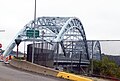
 The bridge in 2006 | |
| Coordinates | 40°28′37″N80°02′56″W / 40.47704°N 80.0489°W |
| Carries | 3 lanes of roadway |
| Crosses | Ohio River |
| Locale | McKees Rocks, Pennsylvania |
| Characteristics | |
| Design | Through arch bridge |
| Total length | 7,293 feet (2,223 m) |
| Longest span | 750 feet (228.6 m) |
| Clearance below | 100 feet (30 m) |
| History | |
| Opened | 1931 |
McKees Rocks Bridge | |
  | |
| Location | SR 3104 over Ohio River at Brighton Heights and McKees Rocks, Pennsylvania |
| Built | 1931 |
| Architect | Vernon R. Covell |
| MPS | Highway Bridges Owned by the Commonwealth of Pennsylvania, Department of Transportation TR |
| NRHP reference No. | 88002168 |
| Significant dates | |
| Added to NRHP | November 14, 1988 [1] |
| Designated PHLF | 2003 [2] |
| Location | |
 Interactive map of McKees Rocks Bridge | |
The McKees Rocks Bridge is a steel trussed through arch bridge which carries the Blue Belt, Pittsburgh's innermost beltline, across the Ohio River at Brighton Heights and McKees Rocks, Pennsylvania. It connects Pennsylvania Route 65 with Pennsylvania Route 51, west of the city.