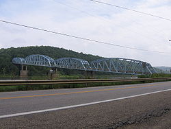
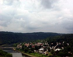
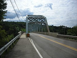
List of crossings of the Allegheny River

Last updated

This is a list of current bridges and other crossings of the Allegheny River starting from Pittsburgh, Pennsylvania, where it joins the Monongahela to form the Ohio River.

Contents

Crossings

Pennsylvania

CrossingCarriesLocationImageCoordinates
Fort Duquesne Bridge I-279.svg I-279 Pittsburgh FortDuquesneBridge.jpg 40°26′39″N80°00′33″W / 40.4443°N 80.0093°W / 40.4443; -80.0093
Allegheny River Tunnel Port Authority T Light Rail
Roberto Clemente Bridge 6th Street Roberto Clemente bridge.jpg 40°26′44″N80°00′12″W / 40.4456°N 80.0033°W / 40.4456; -80.0033
Andy Warhol Bridge 7th Street AndyWarholBridgePittsburgh.JPG 40°26′46″N80°00′05″W / 40.44611°N 80.00139°W / 40.44611; -80.00139
Rachel Carson Bridge 9th Street Pittsburgh Ninth Street Bridge.jpg 40°26′48″N79°59′59″W / 40.4467°N 79.9998°W / 40.4467; -79.9998
Fort Wayne Railroad Bridge Allegheny Valley Railroad, Capitol Limited (Amtrak train), Norfolk Southern Railway Fort Wayne Line Ft Wayne RR Bridge Pittsb jeh.jpg 40°26′54″N79°59′46″W / 40.4482°N 79.9962°W / 40.4482; -79.9962
Veterans Bridge I-579.svg I-579 Veterans Bridge (Pittsburgh).jpg 40°27′00″N79°59′36″W / 40.4499°N 79.9934°W / 40.4499; -79.9934
David McCullough Bridge
(16th Street Bridge)
16th Street 16th st from the strip.jpg 40°27′06″N79°59′27″W / 40.4517°N 79.9909°W / 40.4517; -79.9909
Herr's Island Railroad Bridge (West Penn Bridge)
(rails removed, crosses back channel only)
Three Rivers Heritage Bicycle Trail Herr's Island Railroad Bridge.jpg
30th Street Bridge (crosses back channel only)30th Street 30thstpgh.jpg
William R. Prom Memorial Bridge
(31st Street Bridge)
31st Street 31st Street Bridge, Pittsburgh.jpg 40°27′47″N79°58′33″W / 40.4630°N 79.9758°W / 40.4630; -79.9758
33rd Street Railroad Bridge Allegheny Valley Railroad P&W Subdivision 33rd St. RR Bridge.JPG 40°27′57″N79°58′25″W / 40.4657°N 79.9736°W / 40.4657; -79.9736
Washington Crossing Bridge
(40th Street Bridge)
40th Street Pittsburgh and Millvale FortiethStreetBridge.jpg 40°28′22″N79°58′07″W / 40.4728°N 79.9686°W / 40.4728; -79.9686
Senator Robert D. Fleming Bridge
(62nd Street Bridge)
PA-8.svg PA 8 Pittsburgh and Sharpsburg Senator Robert D. Fleming Bridge.jpg 40°29′28″N79°56′17″W / 40.4912°N 79.9381°W / 40.4912; -79.9381
Allegheny River Lock and Dam Two Allegheny River Pittsburgh and O'Hara Township USACE Lock and Dam 2 Allegheny.jpg 40°29′12″N79°54′53″W / 40.4867°N 79.9147°W / 40.4867; -79.9147
Highland Park Bridge Pittsburgh PA Blue Belt shield.svg Pittsburgh PA Green Belt shield.svg Blue Belt/Green Belt USACE Lock and Dam 2 Allegheny.jpg 40°29′21″N79°54′43″W / 40.4891°N 79.9120°W / 40.4891; -79.9120
Brilliant Branch Railroad Bridge Allegheny Valley Railroad Brilliant Branch Pittsburgh and Aspinwall Allegheny River (2149775625).jpg 40°29′12″N79°54′19″W / 40.4866°N 79.9053°W / 40.4866; -79.9053
Jonathon Hulton Bridge Hulton Road Oakmont and Harmar Township Jonathon Hulton Bridge.jpg 40°31′42″N79°50′48″W / 40.5283°N 79.8467°W / 40.5283; -79.8467
Allegheny River Turnpike Bridge [1] I-76.svg I-76 ( Pennsylvania Turnpike ) Plum and Harmar Township Allegheny River Bridge near the Allegheny Valley Interchange on the Pennsylvania Turnpike (85098).jpg 40°32′14″N79°49′20″W / 40.5373°N 79.8222°W / 40.5373; -79.8222
Bessemer & Lake Erie Railroad Bridge Bessemer and Lake Erie Railroad B&lerr.jpg 40°32′15″N79°49′15″W / 40.5376°N 79.8209°W / 40.5376; -79.8209
C. W. Bill Young Lock and Dam (Allegheny River Lock and Dam Three) Allegheny River 40°32′18″N79°48′55″W / 40.5382°N 79.8154°W / 40.5382; -79.8154
Logans Ferry Mine Tunnel (abandoned)Logans Ferry Coal Mine to Springdale Reliant Energy Power Plant Plum and Springdale 40°32′42″N79°45′50″W / 40.5450°N 79.7640°W / 40.5450; -79.7640
C.L. Schmitt Bridge (9th Street Bridge)9th Street New Kensington and Springdale Township
George D. Stuart Bridge
(Tarentum Bridge)
PA-366.svg PA 366 New Kensington and Tarentum Tarentumbridge.jpg
Allegheny River Lock and Dam Four Allegheny River Lower Burrell and Harrison Township 40°36′54″N79°43′05″W / 40.6150°N 79.7181°W / 40.6150; -79.7181
Donald R. Lobaugh Bridge (Freeport Bridge)PA-356.svg PA 356 Allegheny Township and Buffalo Township Freeport bridge.jpg
Freeport Rail Bridge Norfolk Southern Railway Pittsburgh Line Allegheny Township and Freeport Freeport Rail Bridge - over Allegheny 03.JPG
Allegheny River Lock and Dam Five Allegheny River Gilpin Township and South Buffalo Township 40°41′00″N79°39′59″W / 40.6833°N 79.6664°W / 40.6833; -79.6664
Allegheny River Lock and Dam Six Allegheny River Bethel Township and South Buffalo Township 40°43′00″N79°34′47″W / 40.7167°N 79.5797°W / 40.7167; -79.5797
Ford City Veterans Bridge PA-128.svg PA 128 Ford City and North Buffalo Township
Judge J. Frank Graff Bridge (Kittanning–Ford City Bridge)US 422.svgPA-28.svg US 422  / PA 28 Manor Township and North Buffalo Township Frankgraffbridge.jpg
Kittanning Citizens Bridge Business plate.svg
US 422.svg
US 422 Bus.
Kittanning and West Kittanning Kittanning Citizen's Bridge.JPG
Allegheny River Lock and Dam Seven Allegheny River 40°49′06″N79°31′41″W / 40.8183°N 79.5281°W / 40.8183; -79.5281
Bridgeburg Rail Bridge Buffalo and Pittsburgh Railroad mainline, formerly the Buffalo, Rochester and Pittsburgh Railway Rayburn Township and East Franklin Township
Allegheny River Lock and Dam Eight Allegheny River Pine Township and Washington Township 40°53′42″N79°28′41″W / 40.8950°N 79.4780°W / 40.8950; -79.4780
Reesedale Railroad Bridge Buffalo and Pittsburgh Railroad, Pittsburg and Shawmut Railroad branch
Allegheny River Lock and Dam Nine Allegheny River Madison Township and Washington Township 40°57′18″N79°32′53″W / 40.9550°N 79.5481°W / 40.9550; -79.5481
Sergeant Carl F. Curran II Bridge (East Brady Bridge)PA-68.svg PA 68 East Brady and Brady's Bend Township Sergeant Carl F. Curran II Bridge under construction.jpg
Parker Bridge PA-368.svg PA 368 Perry Township and Parker Parker Bridge.jpg
Foxburg Bridge PA-58.svg PA 58 Foxburg and Hovey Township Foxburg Bridge (2008).JPG
Emlenton Bridge I-80.svg I-80 Richland Township and Allegheny Township Interstate 80 - Pennsylvania.jpg
Emlenton Low Level Bridge PA-38.svg PA 38 Emlenton Emlenton, Pennsylvania.JPG 41°10′33″N79°42′29″W / 41.1757°N 79.7081°W / 41.1757; -79.7081
Kennerdell Bridge Kenderell Road Rockland Township and Clinton Township
Belmar Railroad Bridge (rails removed)Allegheny River Bike Trail Cranberry Township and Sandycreek Township
Eighth Street Bridge US 322.svg US 322 Cranberry Township and Franklin
Petroleum Street Bridge US 62.svg US 62 Oil City
Veterans Memorial Bridge State Street Oil City
Oil City Pennsylvania Railroad Bridge Western New York and Pennsylvania Railroad Oil City and Cranberry Township Oilcityrrbridge.jpg
Hunter Station Bridge US 62.svg US 62 Tionesta Township
Tionesta Bridge US 62.svgPA-36.svg US 62  / PA 36 Tionesta and Tionesta Township
West Hickory Bridge PA-127.svg PA 127 Hickory Township and Harmony Township West Hickory Bridge.jpg
Tidioute Bridge PA-127.svg PA 127 Limestone Township and Tidioute Tidioute Bridge.jpg
Irvine Bridge US 62.svg US 62 Pleasant Township and Conewango Township
National Forge Bridge US 6.svg US 6 Pleasant Township and Warren
West Warren Railroad Bridge Buffalo and Pittsburgh Railroad Northern Subdivision
Hickory Street Bridge Hickory Street
East Warren Railroad Bridge Buffalo and Pittsburgh Railroad Warren Branch Mead Township and Warren
Glade Bridge Business plate.svg
US 6.svg
US 6 Bus.
Kinzua Dam Allegheny River Mead Township and Glade Township Kinzua Dam, July 2015.jpg

New York

CrossingCarriesLocationCoordinates
Quaker Bridge (demolished)NY-280.svg NY 280 Coldspring Electric lines still cross river at the site.
Kinzua High Level Bridge I-86.svg I-86 Red House and Coldspring
Allegheny Reservation Bridge (closed to all traffic)NY-17.svg NY 17 (old) Red House and Allegheny Indian Reservation
Cornplanter Bridge NY-353.svg NY 353 Salamanca
Main Street Bridge Salamanca
Clinton Street Bridge US 219 (NY).svgNY-417.svg US 219  / NY 417 Salamanca
Riverside Junction Railroad Bridge Buffalo and Pittsburgh Railroad Salamanca line Great Valley and Carrollton
Old Riverside Junction Railroad Bridge (abandoned)former Buffalo and Pittsburgh Railroad Salamanca line
Cattaraugus County Veterans Memorial Bridge I-86.svg I-86
Bemus Bridge US 219 (NY).svg US 219
Nine Mile Road Bridge (abandoned) Allegeny and Carrollton
Allegany Bridge I-86.svg I-86 Allegeny and Olean
First Street Bridge
South Union Street- Veterans Memorial Bridge NY-16.svg NY 16 Olean
Steam Valley Bridge Portville
Gleason Hollow Bridge Portville

Pennsylvania

CrossingCarriesLocationCoordinates
Kendall Bridge PA-346.svg PA 346 Eldred and Eldred Township
Larabee Bridge PA-446.svg PA 446 Eldred Township
WNY&P Bridge Western New York and Pennsylvania Railroad
Champlain Hill Bridge Annin Township
Richard Lilli Bridge US 6.svg US 6 Port Allegany and Liberty Township
West Mill Street Bridge PA-155.svg PA 155
Emporium Bridge PA-155.svg PA 155
South Turtle Road Bridge Liberty Township
Kim Hill Road Bridge Roulette Township
Pomeroy Street Bridge
Maple Street Bridge
Celaschi Covered Bridge Eulalia Township
Olastead Road Bridge
Toles Hollow Bridge Coudersport and Eulalia Township
Chestnut Street Bridge Coudersport
Coudersport Main Street Bridge US 6.svg US 6
Allegheny Avenue Bridge
Second Street Bridge US 6.svg US 6
Fourth Street Bridge (abandoned)
Seventh Street Bridge
Avenue A Bridge Coudersport and Eulalia Township
Prosser Hollow Bridge Eulalia Township and Sweden Township
Colesburg Bridge Sweden Township
PA 49 Bridge PA-49.svg PA 49 Sweden Township and Ulysses Township

See also

Related Research Articles

<span class="mw-page-title-main">Ohio River</span> Major river in the midwestern United States

The Ohio River is a 981-mile (1,579 km) long river in the United States. It is located at the boundary of the Midwestern and Southern United States, flowing in a southwesterly direction from western Pennsylvania to its mouth on the Mississippi River at the southern tip of Illinois. It is the third largest river by discharge volume in the United States and the largest tributary by volume of the north-south flowing Mississippi River, which divides the eastern from western United States. It is also the 6th oldest river on the North American continent. The river flows through or along the border of six states, and its drainage basin includes parts of 14 states. Through its largest tributary, the Tennessee River, the basin includes several states of the southeastern U.S. It is the source of drinking water for five million people.

<span class="mw-page-title-main">Monongahela River</span> River in Pennsylvania and West Virginia, United States

The Monongahela River, sometimes referred to locally as the Mon, is a 130-mile-long (210 km) river on the Allegheny Plateau in north-central West Virginia and Southwestern Pennsylvania. The river flows from the confluence of its west and east forks in north-central West Virginia northeasterly into southwestern Pennsylvania, then northerly to Pittsburgh and its confluence with the Allegheny River to form the Ohio River. The river includes a series of locks and dams that makes it navigable.

<span class="mw-page-title-main">Great Allegheny Passage</span> Rail trail connecting Cumberland, Maryland and Pittsburgh, Pennsylvania

The Great Allegheny Passage (GAP) is a 150-mile (240 km) rail trail between Pittsburgh, Pennsylvania and Cumberland, Maryland. Together with the C&O Canal towpath, the GAP is part of a 335 mi (539 km) route between Pittsburgh and Washington, D.C., that is popular with through hikers and cyclists.

<span class="mw-page-title-main">Allegheny County belt system</span> Allegheny County belt system

The Allegheny County Belt System color codes various county roads to form a unique system of routes in Allegheny County, Pennsylvania, and around the city of Pittsburgh.

<span class="mw-page-title-main">Smithfield Street Bridge</span> Bridge over the Monongahela River in Pittsburgh, Pennsylvania

The Smithfield Street Bridge is a lenticular truss bridge crossing the Monongahela River in Pittsburgh, Pennsylvania, USA.

<span class="mw-page-title-main">Hot Metal Bridge</span> Bridge over the Monongahela River in Pittsburgh, Pennsylvania

The Hot Metal Bridge is a truss bridge in Pittsburgh, Pennsylvania, that crosses the Monongahela River. The bridge consists of two parallel spans on a single set of piers: the former Monongahela Connecting Railroad Bridge, built in 1887, on the upstream side and the former Hot Metal Bridge, built in 1900, on the downstream side. The Monongahela Connecting Railroad Bridge carried conventional railroad traffic, while the Hot Metal Bridge connected parts of the J&L Steel mill, carrying crucibles of molten iron from the blast furnaces in ladle transfer cars to the open hearth furnaces on the opposite bank to be converted to steel. During World War II 15% of America's steel making capacity crossed over the Hot Metal Bridge, up to 180 tons per hour. The upstream span was converted to road use after a $14.6 million restoration, and opened by Mayor Tom Murphy with a ceremony honoring former steel workers on June 23, 2000. The bridge connects 2nd Avenue at the Pittsburgh Technology Center in South Oakland with Hot Metal Street in the South Side. The downstream span reopened for pedestrian and bicycle use in late 2007 after two years of work. The Great Allegheny Passage hiker/biker trail passes over this bridge as it approaches Pittsburgh's Golden Triangle area.

<span class="mw-page-title-main">Glenwood B&O Railroad Bridge</span> Bridge in Pittsburgh, Pennsylvania

The Glenwood B&O Railroad Bridge is a truss bridge in Pittsburgh, Pennsylvania, which carries Allegheny Valley Railroad's W&P Subdivision over the Monongahela River.

<span class="mw-page-title-main">West End Bridge</span> Bridge in Pittsburgh, Pennsylvania

The West End Bridge is a steel tied-arch bridge over the Ohio River in Pittsburgh, Pennsylvania, approximately 1 mile (1.6 km) below the confluence of the Allegheny and Monongahela Rivers. It connects the West End to the Chateau neighborhood on the North Side of Pittsburgh.

<span class="mw-page-title-main">Ohio Connecting Railroad Bridge</span> Bridge in Pittsburgh, Pennsylvania

The Ohio Connecting Railroad Bridge is a steel bridge which crosses the Ohio River at Brunot's Island at the west end of Pittsburgh, Pennsylvania, United States. It consists of two major through truss spans over the main and back channels of the river, of 508 feet (155 m) and 406 feet (124 m) respectively, with deck truss approaches.

<span class="mw-page-title-main">Transportation in Pittsburgh</span> Transportation in Pittsburgh, Pennsylvania, United States

Transportation in Pittsburgh, Pennsylvania is different than in many other major American cities. A large metropolitan area that is surrounded by rivers and hills, Pittsburgh has an infrastructure system that has been built out over the years to include roads, tunnels, bridges, railroads, inclines, bike paths, and stairways; however, the hills and rivers still form many barriers to transportation within the city.

<span class="mw-page-title-main">Allegheny Islands State Park</span> Park on three Allegheny River islands in Allegheny County, Pennsylvania

Allegheny Islands State Park is a 43-acre (17 ha) Pennsylvania state park in Harmar Township, Allegheny County, Pennsylvania in the United States. The undeveloped park is composed of three alluvial islands located in the middle of the Allegheny River northeast of Pittsburgh. The islands are just north of the boroughs of Oakmont and Plum, and southwest of Cheswick. Bridges for the Pennsylvania Turnpike and the Bessemer and Lake Erie Railroad Branch of the Canadian National Railway cross the Allegheny River at the middle island.

<span class="mw-page-title-main">Pennsylvania Route 51</span> State highway in Pennsylvania

Pennsylvania Route 51 is a major state highway that is located in Western Pennsylvania in the United States. It runs for 89 miles (143 km) from Uniontown to the Ohio state line near Darlington, where it connects with Ohio State Route 14.

<span class="mw-page-title-main">Pennsylvania Route 837</span> State highway in Washington and Allegheny counties in Pennsylvania, US

Pennsylvania Route 837 is a state route located in western Pennsylvania. The southern terminus of the route is at Pennsylvania Route 88 in the Carroll Township hamlet of Wickerham Manor. The northern terminus is at U.S. Route 19 and PA 51 near downtown Pittsburgh at the junction of the Ohio, Allegheny and Monongahela rivers. The highway parallels the Monongahela River for all of its route with the exceptions of its extreme north and south ends. Popular amusement park Kennywood is located along this route.

<span class="mw-page-title-main">Three Rivers Heritage Trail</span>

The Three Rivers Heritage Trail is an urban rail trail paralleling the riverbanks in Pittsburgh, Pennsylvania and Allegheny County for about 33 miles (53 km), often on both sides of the rivers, and offering views of the city. The trail is promoted and maintained in part by the 'Friends of the Riverfront'.

<span class="mw-page-title-main">McKeesport–Duquesne Bridge</span> Bridge in Pennsylvania and Duquesne, Pennsylvania

The McKeesport-Duquesne Bridge it is a truss bridge that carries vehicular traffic across the Monongahela River between McKeesport, Pennsylvania and Duquesne, Pennsylvania. The bridge connects Route 837 in Duquesne and Route 148 in McKeesport.

<span class="mw-page-title-main">Brilliant Branch Railroad Bridge</span> Bridge in Pittsburgh and Aspinwall

The Brilliant Branch Railroad Bridge is a truss bridge that carries Allegheny Valley Railroad's Brilliant Branch across the Allegheny River between the Pittsburgh neighborhood of Highland Park and the borough of Aspinwall, Pennsylvania.

<span class="mw-page-title-main">Point Bridge (Pittsburgh)</span> Bridge in Pittsburgh, Pennsylvania

The Point Bridge was a steel cantilever truss bridge that spanned the Monongahela River in Pittsburgh, Pennsylvania.

References