Jonathon Hulton Bridge

Last updated

Jonathon Hulton Bridge
Jonathon Hulton Bridge.jpg
Coordinates 40°31′42″N79°50′48″W / 40.5283°N 79.8466°W / 40.5283; -79.8466 Coordinates: 40°31′42″N79°50′48″W / 40.5283°N 79.8466°W / 40.5283; -79.8466
Carries2 lanes of Allegheny County SR 2082
Crosses Allegheny River
Locale Oakmont, Pennsylvania
Official nameJonathon Hulton Bridge
Other name(s)Hulton Bridge
Maintained by PennDOT
Characteristics
Designsubdivided Parker Pratt through truss
MaterialSteel
Total length470.6 metres (1,544 ft)
Longest span140.2 metres (460 ft)
No. of spans5
Piers in water3
Clearance below 15.2 metres (50 ft)
History
OpenedSpring of 1910
ClosedOctober 5, 2015 (demolished January 26, 2016)
Statistics
Daily traffic 22,312
Location
Jonathon Hulton Bridge
Jonathon Hulton Bridge from the road deck Hulton Bridge.jpg
Jonathon Hulton Bridge from the road deck

The Jonathon Hulton Bridge, built in 1908, was the first major bridge designed by Allegheny County, Pennsylvania. [1] Spanning the Allegheny River, it connected the eastern Pittsburgh suburbs of Oakmont and Harmarville, Pennsylvania.

Contents

History

The bridge was a Parker Pratt through Truss bridge. These bridges were common in the early 20th century for car and rail traffic. [2] The bridge was named for Jonathon Hulton, one of the first landowners in the Oakmont area. The Hulton family also operated a ferry across the Allegheny River near the current bridge location until its construction.

In 1989 the PA Legislature approved the renaming of the bridge in honor of the late Pennsylvania Representative Joseph F. Bonetto. Plaques were unceremoniously attached to the bridge, and three days later they were removed and never seen again. New larger plaques were put in their place confirming that it was indeed the Jonathon Hulton Bridge. [3] Prior to its implosion, the Hulton Bridge was painted a lavender color, a byproduct of the 1991 refurbishment of the bridge. [4] The last reported crossing of the bridge was by Andy Galata and Jerry Lyons in a BMW Convertible. There is a video record of this titled Memory on the Raidervision Youtube Page.[ citation needed ]

The new Hulton Bridge over the Allegheny River from the parking lot of Riverview High School Hulton Bridge - 20200706.jpg
The new Hulton Bridge over the Allegheny River from the parking lot of Riverview High School

Replacement project

Construction of a 1,600-foot (490 m)-long steel multi-girder replacement bridge just upstream of the original bridge began in September 2013. [5] [6] [7] [8] [9] The new bridge, which opened to traffic on October 20, 2015, [10] [11] [12] [13] has four 11-foot (3.4 m)-wide traffic lanes (2 in each direction), one 4-foot (1.2 m)-wide median, one 4-foot (1.2 m)-wide shoulder on each side of the roadway, and a 5-foot (1.5 m)-wide ADA-compliant sidewalk on the bridge's southern side. [13] [14]

Aside from the new bridge itself, the scope of the $65 million replacement project also included realignment and reconstruction of parts of Freeport and Hulton roads, relocation of utilities, drainage, pavement markings, and improvements to intersections, lighting, traffic signals, curbs, and sidewalks. [12] [14] Six buildings on the Harmar side of the river were demolished to facilitate construction. [15] The entire project, including implosion of the original bridge, was completed in spring 2016, in time for the 2016 U.S. Open at nearby Oakmont Country Club.

The replacement span was designed by Pennsylvania-based engineering firms Gannett Fleming and McCormick Taylor. [4] [16] [17] Brayman Construction Corporation of Saxonburg, Pennsylvania was the general contractor for the project. [5] [6] [15] [17] Roughly 80% of the project's funding was provided by the federal government. [15]

In 2009, when PennDOT announced the plan to replace and demolish the old bridge, engineering students from Carnegie Mellon University proposed to instead convert it into a pedestrian walkway and connect Oakmont to the Allegheny River Trail. [1] [18] [19] However, it was determined that this conversion would be too costly, and that the old bridge would be demolished as originally planned. [3] [5] [7] [13]

The old bridge was imploded successfully at 9:50 a.m. on January 26, 2016. [20] The implosion could be seen from the Harmar Bald Eagle Camera.

See also

Related Research Articles

<span class="mw-page-title-main">Pennsylvania Turnpike</span> East–west toll highway

The Pennsylvania Turnpike is a toll highway operated by the Pennsylvania Turnpike Commission (PTC) in the U.S. state of Pennsylvania. A controlled-access highway, it runs for 360 miles (580 km) across the state. The turnpike's western terminus is at the Ohio state line in Lawrence County, where the road continues west as the Ohio Turnpike. The eastern terminus is at the New Jersey state line at the Delaware River–Turnpike Toll Bridge over the Delaware River in Bucks County, where the road continues east as the Pearl Harbor Memorial Extension of the New Jersey Turnpike.

<span class="mw-page-title-main">Harmar Township, Allegheny County, Pennsylvania</span> Township in Pennsylvania, United States

Harmar Township is a township in Allegheny County, Pennsylvania, United States. The population was 3,136 at the 2020 census.

<span class="mw-page-title-main">Oakmont, Pennsylvania</span> Borough in Pennsylvania, United States

Oakmont is a borough in Allegheny County, in the U.S. state of Pennsylvania. It is a Pittsburgh suburb and part of the Pittsburgh Metro Area. The population was 6,758 as of the 2020 Census.

<span class="mw-page-title-main">Penn Hills, Pennsylvania</span> Home rule township in Pennsylvania, United States

Penn Hills is a township with home rule status in Allegheny County, Pennsylvania, United States. The population was 41,059 as of the 2020 census. A suburb of Pittsburgh, Penn Hills is the second-largest municipality in Allegheny County.

<span class="mw-page-title-main">Plum, Pennsylvania</span> Borough in Pennsylvania, United States

Plum is a borough in Allegheny County, Pennsylvania, United States. The population was 27,144 at the 2020 census. A suburb of the Pittsburgh metropolitan area, it is located northeast of the city in what is commonly referred to as the East Hills suburbs.

<span class="mw-page-title-main">Interstate 279</span> Highway in Pennsylvania, United States

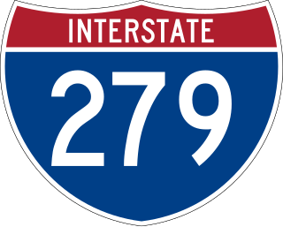
Interstate 279 (I-279), locally referred to as Parkway North, is a north–south auxiliary Interstate Highway that lies entirely within Allegheny County, Pennsylvania. Its southern end is at I-376 at the Fort Pitt Bridge in Pittsburgh, and the north end is in Franklin Park at I-79. It primarily serves at the main access route between Pittsburgh and its northern suburbs.

The Pennsylvania Department of Transportation (PennDOT) oversees transportation issues in the Commonwealth of Pennsylvania. The administrator of PennDOT is the Pennsylvania Secretary of Transportation, currently Michael B. Carroll. PennDOT supports over 40,500 miles (65,200 km) of state roads and highways, about 25,000 bridges, and new roadway construction with the exception of the Pennsylvania Turnpike Commission.

<span class="mw-page-title-main">Pennsylvania Route 576</span> Toll highway in Pennsylvania

Pennsylvania Route 576 (PA Turnpike 576), also known as the Southern Beltway, is a tolled freeway in the southern and western suburbs of Pittsburgh, Pennsylvania, United States. It is envisioned to serve as a southern beltway around the Greater Pittsburgh area between Pittsburgh International Airport and the historic Steel Valley of the Monongahela River.

<span class="mw-page-title-main">Pennsylvania Route 28</span> State highway in Pennsylvania, US

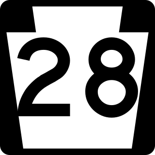
Pennsylvania Route 28 is a major state highway which runs for 98 miles (158 km) from Anderson Street in Pittsburgh to U.S. Route 219 (US 219) in Brockway in Pennsylvania. From Pittsburgh to Kittanning it is a 44.5-mile-long (71.6 km) limited access expressway named the Alexander H. Lindsay Memorial Highway or the Allegheny Valley Expressway.

The Mon–Fayette Expressway is a partially-completed tolled freeway that is planned to eventually link Interstate 68 near Morgantown, West Virginia with Interstate 376 near Monroeville, Pennsylvania. The ultimate goal of the highway is to provide a high speed north–south connection between Morgantown and the eastern side of Pittsburgh while revitalizing economically distressed Monongahela River Valley towns in Fayette and Washington counties, serving as an alternative to Interstate 79 to the west, as well as relieving the PA 51 alignment from Pittsburgh to Uniontown.

<span class="mw-page-title-main">Liberty Bridge (Pittsburgh)</span> Bridge in Pittsburgh, Pennsylvania

The Liberty Bridge, completed in 1928, connects downtown Pittsburgh, Pennsylvania, to the Liberty Tunnels and the South Hills neighborhoods beyond. It crosses the Monongahela River and intersects Interstate 579 at its northern terminus.

<span class="mw-page-title-main">South Tenth Street Bridge</span> Bridge in Pittsburgh, Pennsylvania

South Tenth Street Bridge, most often called the Tenth Street Bridge, but officially dubbed the Philip Murray Bridge, is a suspension bridge spanning the Monongahela River in Downtown Pittsburgh, Pennsylvania. It is the only cable suspension bridge in Allegheny County and its 725-foot (221 m) main span is the longest span on the Monongahela River. The bridge was renamed on Labor Day 2007 for Philip Murray, the first president of the United Steelworkers of America.

<span class="mw-page-title-main">Birmingham Bridge</span> Bridge in Pittsburgh, Pennsylvania

The Birmingham Bridge is a bowstring arch bridge in Pittsburgh, Pennsylvania, which crosses over the Monongahela River. The bridge connects East Carson Street on the South Side with Fifth and Forbes Avenues going to Uptown, Oakland, and the Hill District. It is named in honor of the English city of Birmingham and also for the neighborhood it connects to, which was once called Birmingham, now a part of the South Side. Many locals also may refer to it by its unofficial name, the 22nd Street Bridge.

<span class="mw-page-title-main">Andy Warhol Bridge</span> Bridge over the Allegheny River in Pittsburgh

Andy Warhol Bridge, also known as the Seventh Street Bridge, spans the Allegheny River in Downtown Pittsburgh. It is the only bridge in the United States named for a visual artist. It was opened at a cost of $1.5 million on June 17, 1926, in a ceremony attended by 2,000.

<span class="mw-page-title-main">Neville Island Bridge</span> Bridge in Allegheny County, Pennsylvania.

The Neville Island Bridge is a tied arch bridge which carries Interstate 79 and the Yellow Belt across the Ohio River and over Neville Island, west of Pittsburgh, Pennsylvania.
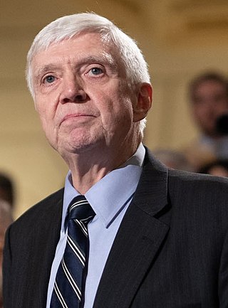
<span class="mw-page-title-main">U.S. Route 19 in Pennsylvania</span>

U.S. Route 19 in Pennsylvania closely parallels Interstate 79 (I-79) for its entire length. US 19 enters Pennsylvania from West Virginia in Greene County near Mount Morris. Its northern terminus is at US 20 in the city of Erie. Part of it is named for Commodore Oliver Hazard Perry, hero of the Battle of Lake Erie.

<span class="mw-page-title-main">Fleming Park Bridge</span> Bridge in Pennsylvania and Stowe Township, Pennsylvania

The Fleming Park Bridge is a through truss bridge which spans the back channel of the Ohio River, between Neville Island and Stowe Township, PA. Although the Ohio River's back channel is only 590 feet wide, roughly 660 feet of this newer bridge was erected over water due to the unique 65 degree angle of the structure's trajectory.

<span class="mw-page-title-main">Allegheny River Turnpike Bridge</span> Bridge in Harmar Township and Plum, Pennsylvania

The Allegheny River Turnpike Bridge carries Interstate 76 over the Allegheny River. The structure features a pair of twin 2,350’ cast-in-place concrete segmental bridges. This is the first of its type in Pennsylvania. It was constructed between 2007 and 2010 and is the second bridge to stand on this site. The original truss bridge was built between 1949 and 1951 by the engineering firm Modjeski & Masters; the crossing predates the Interstate System by several years.

<span class="mw-page-title-main">Donald R. Lobaugh Bridge</span> Bridge in Buffalo Township and Allegheny Township

The Donald R. Lobaugh Bridge is a cantilever bridge that carries vehicular traffic across the Allegheny River between Buffalo and Allegheny townships in Pennsylvania.

<span class="mw-page-title-main">Masontown Bridge</span> Bridge in Greene County, Pennsylvania

The Masontown Bridge is a four-lane concrete plate girder bridge that carries vehicular traffic across the Monongahela River between Masontown, Pennsylvania and Monongahela Township, Greene County, Pennsylvania by way of Pennsylvania Route 21.

References

  1. 1 2 Kate Luce Angell "Plan presented to save Hulton Bridge" post-gazette.com [Pittsburgh] December 24, 2009 5:56 am March 10, 2012 http://www.post-gazette.com/stories/local/neighborhoods-east/plan-presented-to-save-hulton-bridge-372845/
  2. Condit, Carl. American Building Art. New York: Oxford University Press, 1961. Print
  3. 1 2 Hanz, Joyce (October 26, 2014). "Hulton Bridge to be focus of Oakmont historian's talk". Pittsburgh Tribune-Review . Retrieved October 21, 2015.
  4. 1 2 Jon, Schmitz (February 16, 2009). "Plans for new Hulton Bridge put on display". Pittsburgh Post-Gazette .
  5. 1 2 3 Yerace, Tom (September 13, 2013). "Work to start Monday on new Hulton Bridge". Tribune-Review.
  6. 1 2 "Brayman Construction Corporation Heavy Civil & Geotechnical Contractors :: Hulton Bridge".
  7. 1 2 "Hulton Bridge Replacement : Construction Schedule".
  8. Thomas, Mary Ann (December 1, 2013). "Chill won't halt Hulton Bridge work". Tribute-Review.
  9. Dezayas, Heidi (July 7, 2013). "Hulton Bridge Replacement: New Photo Rendering". Plum-Oakmont Patch.
  10. "Brand new Hulton Bridge opened to traffic". WPXI. October 20, 2015. Retrieved October 21, 2015.
  11. "TRAFFIC: Hulton Bridge closes until Oct. 20, when new span opens". Pittsburgh Post-Gazette. October 5, 2015.
  12. 1 2 "Hulton Bridge Replacement : HULTON BRIDGE TO CLOSE OCTOBER 5 TO OCTOBER 20".
  13. 1 2 3 Schmitz, Jon (September 25, 2015). "Hulton Bridge replacement nears completion". Pittsburgh Post-Gazette.
  14. 1 2 "Hulton Bridge Replacement : Overview".
  15. 1 2 3 Weigland, Jodi (August 2, 2013). "Clinton company may have landed Hulton Bridge project". Tribune-Review.
  16. "PennDOT District 11-0 Roadwork - Future Construction Projects Index - SR 0028, Section A44". PennDOT District 11-0 Roadwork - Future Construction Projects Index. PennDOT. Retrieved April 25, 2012.
  17. 1 2 "Hulton Bridge Replacement : Project Team". Archived from the original on December 7, 2013. Retrieved December 3, 2013.
  18. Santoni, Matthew (December 9, 2009). "Carnegie Mellon students design alternative use for Oakmont bridge". Pittsburgh Tribune Review . Archived from the original on December 13, 2009.
  19. Burns, Erin (February 8, 2010). "Student designers re-imagine Oakmont's historic Hulton bridge". The Tartan . Retrieved October 21, 2015.
  20. "TRAFFIC: Implosion of old Hulton Bridge scheduled Tuesday". January 25, 2016. Retrieved January 25, 2016.