Deerfield River is a river that runs for 76 miles (122 km) from southern Vermont through northwestern Massachusetts to the Connecticut River. The Deerfield was historically influential in the settlement of western Franklin County, Massachusetts, and its namesake town. The Deerfield River is the Connecticut River's second longest tributary in Massachusetts, 2.1 miles (3.4 km) shorter than the Metropolitan Springfield's Westfield River.
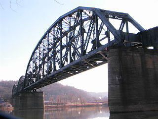
The Glenwood B&O Railroad Bridge is a truss bridge in Pittsburgh, Pennsylvania, which carries Allegheny Valley Railroad's W&P Subdivision over the Monongahela River.
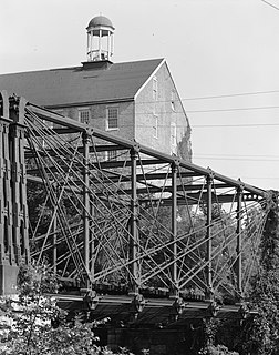
The Bollman Truss Railroad Bridge at Savage, Maryland is the sole surviving example of a revolutionary design in the history of American bridge engineering. The 160-foot (48.8 m) double-span truss bridge is one of the oldest standing iron railroad bridges in the United States. Currently, however, it is in use carrying the Savage Mill Trail across the Little Patuxent River. It was the first successful all-metal bridge design to be adopted and consistently used on a railroad. The type was named for its inventor, Wendel Bollman, a self-educated Baltimore civil engineer.
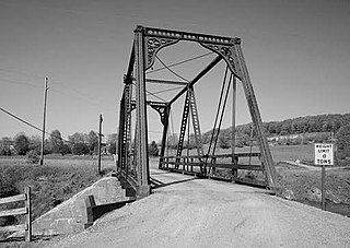
The Wills Creek Bollman Bridge originally served the Baltimore and Ohio Railroad's Pittsburgh Division main line.

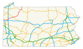
Allegheny Islands State Park is a 43-acre (17 ha) Pennsylvania state park in Harmar Township, Allegheny County, Pennsylvania in the United States. The undeveloped park is composed of three alluvial islands located in the middle of the Allegheny River northeast of Pittsburgh. The islands are just north of the boroughs of Oakmont and Plum, and southwest of Cheswick. Bridges for the Pennsylvania Turnpike and the Bessemer and Lake Erie Railroad Branch of the Canadian National Railway cross the Allegheny River at the middle island.

The Allegheny Reservoir is a reservoir along the Allegheny River in Pennsylvania and New York, USA. It was created in 1965 by the construction of the Kinzua Dam along the river.

The 33rd Street Railroad Bridge is a truss bridge that carries the Allegheny Valley Railroad on the P&W Subdivision over the Allegheny River in downtown Pittsburgh, Pennsylvania, United States.

The Senator Robert D. Fleming Bridge, commonly known as the 62nd Street Bridge, is a truss bridge that carries Pennsylvania Route 8 across the Allegheny River between the Pittsburgh neighborhoods of Morningside and Lawrenceville and Sharpsburg, Pennsylvania.
The C.L. Schmitt Bridge is a truss bridge that carries vehicular traffic across the Allegheny River between New Kensington and East Deer Township, Pennsylvania in the United States.

The Judge J. Frank Graff Bridge is a truss bridge that carries U.S. Route 422 (US 422) and Pennsylvania Route 28 (PA 28) across the Allegheny River. It connects Manor Township and North Buffalo Township, Pennsylvania. It was constructed in 1974 as part of a freeway bypass of Kittanning, Pennsylvania. The structure is named for Frank Graff, an Armstrong County Court of Common Pleas Judge who later rose to become a member of the Pennsylvania Superior Court.
The Kennerdell Bridge is a girder bridge connecting Rockland Township and Clinton Township in Venango County, Pennsylvania that serves the tiny village of Kennerdell. Originally, a 1907 truss bridge stood on this site. It was rehabilitated in 1981, but ultimately replaced in 2000. Only about 250 cars use the bridge each day
The Petroleum Street Bridge is a girder bridge connecting the North Side and South Side neighborhoods of Oil City, Pennsylvania and crosses the Allegheny River. The bridge sits just downstream from the confluence of Oil Creek and the Allegheny River. The 1995 structure carries two lanes of U.S. Route 62 and was built during a decade of major refurbishments of Upper Allegheny crossings. Previously, a 1910 truss bridge stood on the site; this structure replaced an earlier wooden bridge.
The Veterans Memorial Bridge is a girder bridge connecting the North Side and South Side neighborhoods of Oil City, Pennsylvania. Built in 1990, the bridge was one of several similar structures constructed during a decade that saw major replacements of Upper Allegheny crossings; an original truss bridge on the site dated to the 1910s. The bridge, which features one northbound and two southbound lanes, is significantly longer than others along this stretch of river. This is mainly due to its crossing of a riverfront park on the Oil City shores.
The Fifteenth Avenue Bridge is a girder bridge across the Youghiogheny River connecting the Pittsburgh industrial suburbs of Port Vue and McKeesport, Pennsylvania. The 1995 structure replaced a 1906 truss bridge. The bridge's length is significantly longer than that of several surrounding structures because its crosses both the river and a large water treatment facility.
The Sutersville Bridge is a structure that crosses the Youghiogheny River between Sutersville and Elizabeth Township, Pennsylvania. It connects a rural southeastern corner of Allegheny County with a small Westmoreland County town.
The Tionesta Bridge is a girder bridge that carries U.S. Route 62 and Pennsylvania Route 36 across the Allegheny River in rural Forest County, Pennsylvania. The borough of Tionesta on the east bank of the river is connected with an unpopulated section of Tionesta Township on the west bank.

The Mill Bridge is a structure that crosses the Kiskiminetas River between West Leechburg and Leechburg in the U.S. state of Pennsylvania.
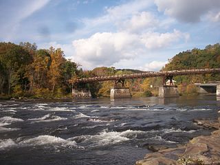
The Ohiopyle Low Bridge is a structure that carries the Great Allegheny Passage trail across the Youghiogheny River in Ohiopyle, Pennsylvania.

Big Run is a river of 13 miles in length, located one-and-a-half miles west of Spruce Knob in Monongahela National Forest, in Pendleton County, West Virginia. It is a tributary of the North Fork South Branch Potomac River.