
Hovey Township is a township in far northern Armstrong County, Pennsylvania, United States. The population was 97 at the 2010 census.

Hickory Township is a township in Forest County, Pennsylvania, United States. As of the 2010 census, the township population was 558.

Tionesta is a borough in Forest County, Pennsylvania, United States. The population was 483 at the 2010 Census. It is the county seat of Forest County. The name is a Native American word meaning "the home of the wolves".
Tionesta Township is a township in Forest County, Pennsylvania, United States. The population was 729 at the 2010 census, up from 610 at the 2000 census.
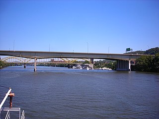
The Veterans Bridge is a steel and welded girder bridge that carries Interstate 579 over the Allegheny River in Pittsburgh, Pennsylvania. Completed in 1988 it cost $420 million. It opened on November 11, 1988 complete with 107th National Guard howitzers firing ceremoniously from the deck, as the last link in I-579. The bridge, 1,050 feet (320 m) in length, has a main span of 410 feet (120 m) and is 51 feet (16 m) above the water. The roadway atop the structure is seven lanes wide, with six lanes dedicated to northbound and southbound traffic and one lane designed for reversible High Occupancy Vehicle (HOV-2) movements.
Baker Island is a 66.9-acre (271,000 m2) alluvial island in the upper Allegheny River. It is located in Tionesta Township and Harmony Township in Forest County, Pennsylvania, and is part of the Allegheny Islands Wilderness in Allegheny National Forest.
No-Name Island is a 10-acre (40,000 m2) alluvial island in the upper Allegheny River. It is located in Tionesta Township, Forest County, Pennsylvania, and is part of the Allegheny Islands Wilderness.
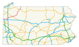
U.S. Route 62 is a signed north-south U.S. Highway in Pennsylvania, which runs diagonally southwest-northeast through the industrial northwestern part of the state. Although initial portions of the route opened in 1926 in other areas of the country, U.S. 62 was not designated in the commonwealth until 1932. The highway connects the small cities of Sharon, Franklin, Oil City, and Warren to larger markets, such as Youngstown, Ohio and Buffalo, New York.

The Judge J. Frank Graff Bridge is a truss bridge that carries U.S. Route 422 (US 422) and Pennsylvania Route 28 (PA 28) across the Allegheny River. It connects Manor Township and North Buffalo Township, Pennsylvania. It was constructed in 1974 as part of a freeway bypass of Kittanning, Pennsylvania. The structure is named for Frank Graff, an Armstrong County Court of Common Pleas Judge who later rose to become a member of the Pennsylvania Superior Court.
The Ford City Veterans Bridge is a girder bridge connecting Ford City and North Buffalo Township, Pennsylvania. It was constructed in 2000 to replace a 1914 structure. The structure was one of the first in the nation to use a new type of high-performance, weather resistant steel.
The Kennerdell Bridge is a girder bridge connecting Rockland Township and Clinton Township in Venango County, Pennsylvania that serves the tiny village of Kennerdell. Originally, a 1907 truss bridge stood on this site. It was rehabilitated in 1981, but ultimately replaced in 2000. Only about 250 cars use the bridge each day
The Memorial Bridge is a structure that crosses the Youghiogheny River, connecting the eastern and western shores of Connellsville, Pennsylvania, USA.
The Petroleum Street Bridge is a girder bridge connecting the North Side and South Side neighborhoods of Oil City, Pennsylvania and crosses the Allegheny River. The bridge sits just downstream from the confluence of Oil Creek and the Allegheny River. The 1995 structure carries two lanes of U.S. Route 62 and was built during a decade of major refurbishments of Upper Allegheny crossings. Previously, a 1910 truss bridge stood on the site; this structure replaced an earlier wooden bridge.
The Veterans Memorial Bridge is a girder bridge connecting the North Side and South Side neighborhoods of Oil City, Pennsylvania. Built in 1990, the bridge was one of several similar structures constructed during a decade that saw major replacements of Upper Allegheny crossings; an original truss bridge on the site dated to the 1910s. The bridge, which features one northbound and two southbound lanes, is significantly longer than others along this stretch of river. This is mainly due to its crossing of a riverfront park on the Oil City shores.
The Fifteenth Avenue Bridge is a girder bridge across the Youghiogheny River connecting the Pittsburgh industrial suburbs of Port Vue and McKeesport, Pennsylvania. The 1995 structure replaced a 1906 truss bridge. The bridge's length is significantly longer than that of several surrounding structures because its crosses both the river and a large water treatment facility.
The Hunter Station Bridge is a truss bridge that carries U.S. Route 62 (US 62) across the Allegheny River in rural Tionesta Township in Forest County, Pennsylvania. The structure was named for a railroad stop on the long defunct Ridgway & Oil City Railroad.

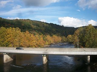
The West Hickory Bridge is a girder bridge that carries Pennsylvania Route 127 across the Allegheny River in rural Forest County, Pennsylvania. Spanning the river between Harmony Township and Hickory Township, it is named for the village of West Hickory.
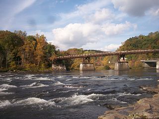
The Ohiopyle Low Bridge is a structure that carries the Great Allegheny Passage trail across the Youghiogheny River in Ohiopyle, Pennsylvania.
The Ohiopyle Highway Bridge is a structure that carries two lanes of Pennsylvania Route 381 Youghiogheny River in Ohiopyle, Pennsylvania

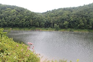
The Pennsylvania State Game Lands Number 24 are Pennsylvania State Game Lands in Clarion, and Forest Counties in Pennsylvania in the United States providing hunting, bird watching, and other activities.


