Madison Township, Armstrong County, Pennsylvania

Last updated
Madison Township,
Armstrong County, Pennsylvania
Allegheny River Lock and Dam No. 9.jpg
Map of Madison Township, Armstrong County, Pennsylvania Highlighted.png
Map of Armstrong County, Pennsylvania highlighting Madison Township
Map of Pennsylvania highlighting Armstrong County.svg
Map of Armstrong County, Pennsylvania
Country United States
State Pennsylvania
County Armstrong
Settled1824
Incorporated1837
Area
[1]
  Total30.92 sq mi (80.07 km2)
  Land30.03 sq mi (77.78 km2)
  Water0.89 sq mi (2.30 km2)
Population
 (2020)
  Total826
  Estimate 
(2021) [2]
820
  Density26.01/sq mi (10.04/km2)
Time zone UTC-5 (Eastern (EST))
  Summer (DST) UTC-4 (EDT)
FIPS code 42-005-46456

Madison Township is a township in Armstrong County, Pennsylvania, United States. The population was 826 at the 2020 census, [2] an increase over the figure of 820 tabulated in 2010. [3]

Contents

History

The Allegheny River Lock and Dam No. 9 and Bridge between Madison and Mahoning Townships are listed on the National Register of Historic Places. [4]

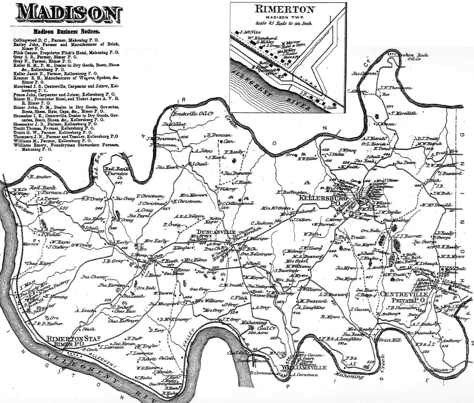
Madison Township appears in the 1876 Atlas of Armstrong County, Pennsylvania. [5] Its early history is detailed in Robert Walter Smith's 1883 History of Armstrong County. [6]

Geography

Madison Township is located along the northern edge of Armstrong County and is bordered on three sides by waterways: Mahoning Creek to the south, the Allegheny River to the south and west, and Redbank Creek

According to the United States Census Bureau, the township has a total area of 30.9 square miles (80.1 km2), of which 30.0 square miles (77.8 km2) is land and 0.89 square miles (2.3 km2), or 2.87%, is water. [3]

Recreation

A portion of Pennsylvania State Game Lands Number 287 is located in the south of Madison Township. [7] [8]

Demographics

Historical population
CensusPop.Note
2010 820
2020 8260.7%
2021 (est.)820 [2] −0.7%
U.S. Decennial Census [9]

As of the census [10] of 2000, there were 943 people, 362 households, and 258 families residing in the township. The population density was 31.1 inhabitants per square mile (12.0/km2). There were 566 housing units at an average density of 18.7/sq mi (7.2/km2). The racial makeup of the township was 98.94% White, 0.42% African American, 0.11% Native American, and 0.53% from two or more races. Hispanic or Latino of any race were 0.53% of the population.

There were 362 households, out of which 31.5% had children under the age of 18 living with them, 62.7% were married couples living together, 4.7% had a female householder with no husband present, and 28.5% were non-families. 26.0% of all households were made up of individuals, and 13.8% had someone living alone who was 65 years of age or older. The average household size was 2.60 and the average family size was 3.12.

The township median age of 38 years was less than that of the county median age of 40 years. The distribution by age group was 24.4% under the age of 18, 8.1% from 18 to 24, 26.8% from 25 to 44, 25.6% from 45 to 64, and 15.2% who were 65 years of age or older. The median age was 38 years. For every 100 females there were 106.3 males. For every 100 females age 18 and over, there were 100.8 males.

The median income for a household in the township was $26,875, and the median income for a family was $35,156. Males had a median income of $30,227 versus $16,667 for females. The per capita income for the township was $12,583. About 14.5% of families and 19.3% of the population were below the poverty line, including 25.1% of those under age 18 and 21.3% of those age 65 or over.

Cemeteries

Related Research Articles

<span class="mw-page-title-main">Bethel Township, Armstrong County, Pennsylvania</span> Township in Pennsylvania, United States

Bethel Township is a township in Armstrong County, Pennsylvania, United States. The population was 1,096 at the 2020 census, a decrease from the figure of 1,183 tabulated in 2010.

<span class="mw-page-title-main">Boggs Township, Armstrong County, Pennsylvania</span> Township in Pennsylvania, United States

Boggs Township is a township in Armstrong County, Pennsylvania, United States. The population was 813 at the 2020 census, a decrease from the figure of 936 tabulated in 2010.

<span class="mw-page-title-main">Burrell Township, Armstrong County, Pennsylvania</span> Township in Pennsylvania, United States

Burrell Township is a township in Armstrong County, Pennsylvania, United States and is part of the Pittsburgh metropolitan area. The population was 659 at the 2020 census, a decrease from the figure of 689 tabulated in 2010.

<span class="mw-page-title-main">Cowanshannock Township, Armstrong County, Pennsylvania</span> Township in Pennsylvania, United States

Cowanshannock Township is a township in Armstrong County, Pennsylvania, United States. The population was 2,742 at the 2020 census, a decrease from the figure of 2,899 tabulated in 2010.

<span class="mw-page-title-main">East Franklin Township, Armstrong County, Pennsylvania</span> Township in Pennsylvania, United States

East Franklin Township is a township in Armstrong County, Pennsylvania, United States. The population was 3,821 at the 2020 census, a decrease from the figure of 4,082 tabulated in 2010.

<span class="mw-page-title-main">Kiskiminetas Township, Armstrong County, Pennsylvania</span> Township in Pennsylvania, United States

Kiskiminetas Township is a township in Armstrong County, Pennsylvania, United States. The population was 4,604 at the 2020 census, a decrease from the figure of 4,800 tabulated in 2010, making it the most populous township or borough in the county.

<span class="mw-page-title-main">Kittanning Township, Armstrong County, Pennsylvania</span> Township in Pennsylvania, United States

Kittanning Township is a township in Armstrong County, Pennsylvania, United States. The population was 2,019 at the 2020 census, a decrease from the figure of 2,265 tabulated in 2010.

<span class="mw-page-title-main">Mahoning Township, Armstrong County, Pennsylvania</span> Township in Pennsylvania, United States

Mahoning Township is a township in Armstrong County, Pennsylvania, United States. The population was 1,406 at the 2020 census, a decrease from 1,425 at the 2010 census.

<span class="mw-page-title-main">Manor Township, Armstrong County, Pennsylvania</span> Township in Pennsylvania, United States

Manor Township is a township in Armstrong County, Pennsylvania, United States. The population was 4,190 at the 2020 census, a decrease from the figure of 4,227 tabulated in 2010.

<span class="mw-page-title-main">North Buffalo Township, Armstrong County, Pennsylvania</span> Township in Pennsylvania, United States

North Buffalo Township is a township in Armstrong County, Pennsylvania, United States. The population was 2,698 at the 2020 census, a decrease from the figure of 3,011 tabulated in 2010.

<span class="mw-page-title-main">Parks Township, Armstrong County, Pennsylvania</span> Township in Pennsylvania, United States

Parks Township is a township in Armstrong County in the U.S. state of Pennsylvania. The population was 2,471 at the 2020 census, a decrease from 2,744 at the 2010 census.

<span class="mw-page-title-main">Perry Township, Armstrong County, Pennsylvania</span> Township in Pennsylvania, United States

Perry Township is a township that is located in Armstrong County, Pennsylvania, United States. The population was 367 at the time of the 2020 census, an increase over the figure of 352 that was tabulated in 2010.

<span class="mw-page-title-main">Plumcreek Township, Armstrong County, Pennsylvania</span> Township in Pennsylvania, United States

Plumcreek Township is a township that is located in Armstrong County, Pennsylvania, United States. The population was 2,106 at the time of the 2020 census, a decrease from the figure of 2,375 that was tabulated in 2010.

<span class="mw-page-title-main">Rayburn Township, Armstrong County, Pennsylvania</span> Township in Pennsylvania, United States

Rayburn Township is a township that is located in Armstrong County, Pennsylvania, United States. The population was 1,766 at the time of the 2020 census, a decrease from the figure of 1,907 that was tabulated in 2010.

<span class="mw-page-title-main">Redbank Township, Armstrong County, Pennsylvania</span> Township in Pennsylvania, United States

Redbank Township is a township in Armstrong County, Pennsylvania, United States. The population was 975 at the 2020 census, a decrease from the figure of 1,064 tabulated in 2010.

<span class="mw-page-title-main">South Bend Township, Armstrong County, Pennsylvania</span> Township in Pennsylvania, United States

South Bend Township is a township in Armstrong County, Pennsylvania, United States. The population was 1,010 at the 2020 census, a decrease from the figure of 1,167 tabulated in 2010.

<span class="mw-page-title-main">South Buffalo Township, Armstrong County, Pennsylvania</span> Township in Pennsylvania, United States

South Buffalo Township is a township in Armstrong County, Pennsylvania, United States. The population was 2,713 at the 2020 census, an increase from the figure of 2,636 tabulated in 2010.

<span class="mw-page-title-main">Valley Township, Armstrong County, Pennsylvania</span> Township in Pennsylvania, United States

Valley Township is a township in Armstrong County, Pennsylvania, United States. The population was 654 at the 2020 census, a decrease from the figure of 656 tabulated in 2010.

<span class="mw-page-title-main">Washington Township, Armstrong County, Pennsylvania</span> Township in Pennsylvania, United States

Washington Township is a township in Armstrong County, Pennsylvania, United States. The population was 898 at the 2020 census, a decrease from 923 at the 2010 census.

<span class="mw-page-title-main">Wayne Township, Armstrong County, Pennsylvania</span> Township in Pennsylvania, United States

Wayne Township is a township in Armstrong County, Pennsylvania, United States. The population was 1,296 at the 2020 census, an increase over the figure of 1,200 tabulated in 2010.

References

  1. "2016 U.S. Gazetteer Files". United States Census Bureau. Retrieved Aug 13, 2017.
  2. 1 2 3 Bureau, US Census. "City and Town Population Totals: 2020-2021". Census.gov. US Census Bureau. Retrieved 28 June 2022.
  3. 1 2 "Geographic Identifiers: 2010 Demographic Profile Data (G001): Madison township, Armstrong County, Pennsylvania". U.S. Census Bureau, American Factfinder. Archived from the original on February 12, 2020. Retrieved August 1, 2013.
  4. "National Register Information System". National Register of Historic Places . National Park Service. July 9, 2010.
  5. "Atlas of Armstrong County Pennsylvania, page 49". Pomeroy, Whitman & Co. 1876. Retrieved 9 November 2018.
  6. Robert Walter Smith (1883). "History of Armstrong County Pennsylvania, Chapter 12, page 259". Chicago: Waterman, Watkins. Retrieved 7 November 2018.
  7. https://viewer.nationalmap.gov/advanced-viewer/ The National Map, retrieved 24 October 2018
  8. Pennsylvania State Game Lands Number 287, retrieved 23 October 2018
  9. "Census of Population and Housing". Census.gov. Retrieved June 4, 2016.
  10. "U.S. Census website". United States Census Bureau . Retrieved 2008-01-31.
  11. "Duncan Cemetery". Geographic Names Information System . United States Geological Survey, United States Department of the Interior.
  12. "Kellersburg Lutheran Cemetery". Geographic Names Information System . United States Geological Survey, United States Department of the Interior.
  13. "Kellersburg Methodist Cemetery". Geographic Names Information System . United States Geological Survey, United States Department of the Interior.
  14. "Reynolds Cemetery". Geographic Names Information System . United States Geological Survey, United States Department of the Interior.
  15. "Rimer Hill Cemetery". Geographic Names Information System . United States Geological Survey, United States Department of the Interior.
  16. "Saint Marys Episcopal Cemetery". Geographic Names Information System . United States Geological Survey, United States Department of the Interior.
  17. "Tidal Cemetery". Geographic Names Information System . United States Geological Survey, United States Department of the Interior.
  18. "Widnoon Methodist Cemetery". Geographic Names Information System . United States Geological Survey, United States Department of the Interior.
40°57′39″N79°27′47″W / 40.96083°N 79.46306°W / 40.96083; -79.46306