Cowanshannock Township, Armstrong County, Pennsylvania

Last updated

Cowanshannock Township, Pennsylvania
Cowanshannock Township hills and forests.jpg
Hills west of Barnards
Map of Cowanshannock Township, Armstrong County, Pennsylvania Highlighted.png
Map of Armstrong County, Pennsylvania highlighting Cowanshannock Township
Map of Pennsylvania highlighting Armstrong County.svg
Map of Armstrong County, Pennsylvania
Country United States
State Pennsylvania
County Armstrong
Settled1807
Incorporated1848
Area
[1]
  Total46.35 sq mi (120.06 km2)
  Land45.66 sq mi (118.27 km2)
  Water0.69 sq mi (1.78 km2)
Population
 (2020)
  Total2,742
  Estimate 
(2021) [2]
2,719
  Density61.56/sq mi (23.77/km2)
Time zone UTC-5 (Eastern (EST))
  Summer (DST) UTC-4 (EDT)
FIPS code 42-005-16728

Cowanshannock Township is a township in Armstrong County, Pennsylvania, United States. The population was 2,742 at the 2020 census, [2] a decrease from the figure of 2,899 tabulated in 2010. [3]

Contents

Geography

According to the United States Census Bureau, the township has a total area of 46.4 square miles (120.1 km2), of which 45.7 square miles (118.3 km2) is land and 0.69 square miles (1.8 km2), or 1.49%, is water. [3]

The boroughs of Atwood and Rural Valley are located within the township, which also includes the villages of Barnards, Blanco, Bryan, Hoosicks Mill, Lumstead, Margaret, Meredith, NuMine, Rose Valley, Sagamore, Smeltzer and Yatesboro.

Streams

Cowanshannock Creek, a tributary of the Allegheny River, flows west through Cowanshannock Township. [4]

Demographics

Historical population
CensusPop.Note
2010 2,899
2020 2,742−5.4%
2021 (est.)2,719 [2] −0.8%
U.S. Decennial Census [5]

As of the 2000 census, [6] of , there were 3,006 people, 1,121 households, and 830 families residing in the township. The population density was 65.9 inhabitants per square mile (25.4/km2). There were 1,210 housing units at an average density of 26.5 per square mile (10.2/km2). The racial makeup of the township was 99.53% White, 0.10% African American, 0.07% Native American, 0.13% Asian, and 0.17% from two or more races. Hispanic or Latino of any race were 0.33% of the population.

There were 1,121 households, out of which 33.8% had children under the age of 18 living with them, 59.7% were married couples living together, 9.0% had a female householder with no husband present, and 25.9% were non-families. 23.3% of all households were made up of individuals, and 12.8% had someone living alone who was 65 years of age or older. The average household size was 2.66 and the average family size was 3.13.

The median age of 37 years was significantly less than that of the county of 40 years. The distribution was 27.1% under the age of 18, 7.2% from 18 to 24, 28.2% from 25 to 44, 21.4% from 45 to 64, and 16.1% who were 65 years of age or older. The median age was 37 years. For every 100 females there were 98.5 males. For every 100 females age 18 and over, there were 95.2 males.

The median income for a household in the township was $28,646, and the median income for a family was $35,372. Males had a median income of $29,485 versus $19,145 for females. The per capita income for the township was $13,598. About 15.4% of families and 16.2% of the population were below the poverty line, including 22.6% of those under age 18 and 7.1% of those age 65 or over.

History

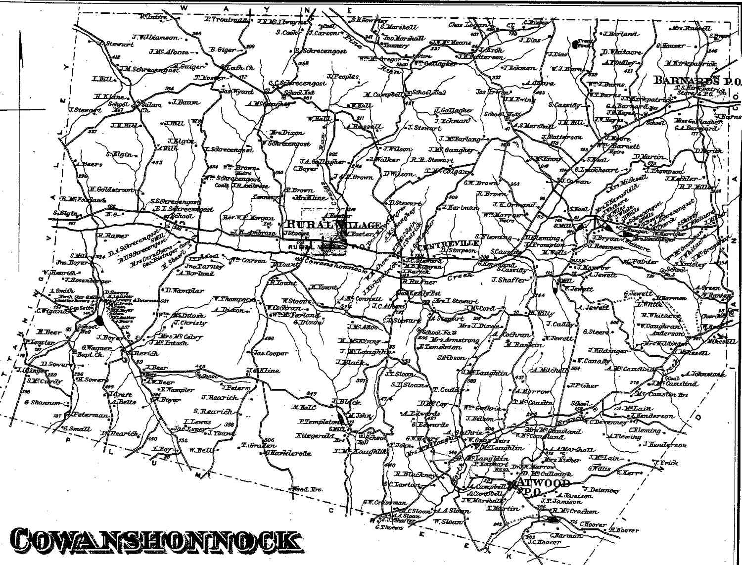
Cowanshannock Township appears in the 1876 Atlas of Armstrong County, Pennsylvania. [7] Its early history is detailed in Robert Walter Smith's 1883 History of Armstrong County. [8]

Cemeteries

Related Research Articles

<span class="mw-page-title-main">Bethel Township, Armstrong County, Pennsylvania</span> Township in Pennsylvania, United States

Bethel Township is a township in Armstrong County, Pennsylvania, United States. The population was 1,096 at the 2020 census, a decrease from the figure of 1,183 tabulated in 2010.

<span class="mw-page-title-main">Bradys Bend Township, Armstrong County, Pennsylvania</span> Township in Pennsylvania, United States

Bradys Bend Township is a township in Armstrong County, Pennsylvania, United States. The population was 784 at the 2020 census, an increase from the figure of 773 tabulated in 2010.

<span class="mw-page-title-main">Burrell Township, Armstrong County, Pennsylvania</span> Township in Pennsylvania, United States

Burrell Township is a township in Armstrong County, Pennsylvania, United States, and is part of the Pittsburgh metropolitan area. The population was 659 at the 2020 census, a decrease from the figure of 689 tabulated in 2010.

<span class="mw-page-title-main">East Franklin Township, Armstrong County, Pennsylvania</span> Township in Pennsylvania, United States

East Franklin Township is a township in Armstrong County, Pennsylvania, United States. The population was 3,821 at the 2020 census, a decrease from the figure of 4,082 tabulated in 2010.

<span class="mw-page-title-main">Kiskiminetas Township, Armstrong County, Pennsylvania</span> Township in Pennsylvania, United States

Kiskiminetas Township is a township in Armstrong County, Pennsylvania, United States. The population was 4,604 at the 2020 census, a decrease from the figure of 4,800 tabulated in 2010, making it the most populous township or borough in the county.

<span class="mw-page-title-main">Kittanning Township, Armstrong County, Pennsylvania</span> Township in Pennsylvania, United States

Kittanning Township is a township in Armstrong County, Pennsylvania, United States. The population was 2,019 at the 2020 census, a decrease from the figure of 2,265 tabulated in 2010.

<span class="mw-page-title-main">Madison Township, Armstrong County, Pennsylvania</span> Township in Pennsylvania, United States

Madison Township is a township in Armstrong County, Pennsylvania, United States. The population was 826 at the 2020 census, an increase over the figure of 820 tabulated in 2010.

<span class="mw-page-title-main">Mahoning Township, Armstrong County, Pennsylvania</span> Township in Pennsylvania, United States

Mahoning Township is a township in Armstrong County, Pennsylvania, United States. The population was 1,406 at the 2020 census, a decrease from 1,425 at the 2010 census.

<span class="mw-page-title-main">Manor Township, Armstrong County, Pennsylvania</span> Township in Pennsylvania, United States

Manor Township is a township in Armstrong County, Pennsylvania, United States. The population was 4,190 at the 2020 census, a decrease from the figure of 4,227 tabulated in 2010.

<span class="mw-page-title-main">North Buffalo Township, Armstrong County, Pennsylvania</span> Township in Pennsylvania, United States

North Buffalo Township is a township in Armstrong County, Pennsylvania, United States. The population was 2,698 at the 2020 census, a decrease from the figure of 3,011 tabulated in 2010.

<span class="mw-page-title-main">Parks Township, Armstrong County, Pennsylvania</span> Township in Pennsylvania, United States

Parks Township is a township in Armstrong County in the U.S. state of Pennsylvania. The population was 2,471 at the 2020 census, a decrease from 2,744 at the 2010 census.

<span class="mw-page-title-main">Perry Township, Armstrong County, Pennsylvania</span> Township in Pennsylvania, United States

Perry Township is a township that is located in Armstrong County, Pennsylvania, United States. The population was 367 at the time of the 2020 census, an increase over the figure of 352 that was tabulated in 2010.

<span class="mw-page-title-main">Plumcreek Township, Armstrong County, Pennsylvania</span> Township in Pennsylvania, United States

Plumcreek Township is a township that is located in Armstrong County, Pennsylvania, United States. The population was 2,106 at the time of the 2020 census, a decrease from the figure of 2,375 that was tabulated in 2010.

<span class="mw-page-title-main">Rayburn Township, Armstrong County, Pennsylvania</span> Township in Pennsylvania, United States

Rayburn Township is a township that is located in Armstrong County, Pennsylvania, United States. The population was 1,766 at the time of the 2020 census, a decrease from the figure of 1,907 that was tabulated in 2010.

<span class="mw-page-title-main">Redbank Township, Armstrong County, Pennsylvania</span> Township in Pennsylvania, United States

Redbank Township is a township in Armstrong County, Pennsylvania, United States. The population was 975 at the 2020 census, a decrease from the figure of 1,064 tabulated in 2010.

<span class="mw-page-title-main">South Buffalo Township, Armstrong County, Pennsylvania</span> Township in Pennsylvania, United States

South Buffalo Township is a township in Armstrong County, Pennsylvania, United States. The population was 2,713 at the 2020 census, an increase from the figure of 2,636 tabulated in 2010.

<span class="mw-page-title-main">Sugarcreek Township, Armstrong County, Pennsylvania</span> Township in Pennsylvania, United States

Sugarcreek Township is a township in Armstrong County, Pennsylvania, United States. The population was 1,336 at the 2020 census, a decrease from the figure of 1,539 tabulated in 2010.

<span class="mw-page-title-main">Valley Township, Armstrong County, Pennsylvania</span> Township in Pennsylvania, United States

Valley Township is a township that is located in Armstrong County, Pennsylvania, United States. The population was 654 at the time of the 2020 census, a decrease from the figure of 656 that was tabulated in 2010.

<span class="mw-page-title-main">Washington Township, Armstrong County, Pennsylvania</span> Township in Pennsylvania, United States

Washington Township is a township in Armstrong County, Pennsylvania, United States. The population was 898 at the 2020 census, a decrease from 923 at the 2010 census.

<span class="mw-page-title-main">Wayne Township, Armstrong County, Pennsylvania</span> Township in Pennsylvania, United States

Wayne Township is a township that is located in Armstrong County, Pennsylvania, United States.

References

  1. "2016 U.S. Gazetteer Files". United States Census Bureau. Retrieved August 13, 2017.
  2. 1 2 3 Bureau, US Census. "City and Town Population Totals: 2020-2021". Census.gov. US Census Bureau. Retrieved June 28, 2022.
  3. 1 2 "Geographic Identifiers: 2010 Demographic Profile Data (G001): Cowanshannock township, Armstrong County, Pennsylvania". U.S. Census Bureau, American Factfinder. Archived from the original on February 12, 2020. Retrieved July 31, 2013.
  4. "Cowanshannock Creek". Geographic Names Information System . United States Geological Survey, United States Department of the Interior . Retrieved November 16, 2010.
  5. "Census of Population and Housing". Census.gov. Retrieved June 4, 2016.
  6. "U.S. Census website". United States Census Bureau . Retrieved January 31, 2008.
  7. "Atlas of Armstrong County Pennsylvania, page 33". Pomeroy, Whitman & Co. 1876. Retrieved November 9, 2018.
  8. Robert Walter Smith (1883). "History of Armstrong County Pennsylvania, Chapter 13, page 286". Chicago: Waterman, Watkins. Retrieved November 7, 2018.
  9. "Dunkard / Slate Hill Cemetery". Geographic Names Information System . United States Geological Survey, United States Department of the Interior.
  10. "Elgin - Old Presbyterian Cemetery". Geographic Names Information System . United States Geological Survey, United States Department of the Interior.
  11. "Harkleroad Cemetery". Geographic Names Information System . United States Geological Survey, United States Department of the Interior.
  12. "McIntosh Cemetery". Geographic Names Information System . United States Geological Survey, United States Department of the Interior.
  13. "Pleasant Union Cemetery". Geographic Names Information System . United States Geological Survey, United States Department of the Interior.
  14. "Saint Johns Cemetery". Geographic Names Information System . United States Geological Survey, United States Department of the Interior.
  15. "Saint Marys Catholic Cemetery". Geographic Names Information System . United States Geological Survey, United States Department of the Interior.
  16. "Saint Pauls Cemetery". Geographic Names Information System . United States Geological Survey, United States Department of the Interior.
  17. "Salem United Church of Christ Cemetery". Geographic Names Information System . United States Geological Survey, United States Department of the Interior.
  18. "Schrecengost Farm Cemetery". Geographic Names Information System . United States Geological Survey, United States Department of the Interior.
  19. "Sowers Cemetery". Geographic Names Information System . United States Geological Survey, United States Department of the Interior.

40°48′12″N79°17′53″W / 40.80333°N 79.29806°W / 40.80333; -79.29806