Mahoning Township, Armstrong County, Pennsylvania

Last updated
Mahoning Township,
Armstrong County, Pennsylvania
Bridge between Madison and Mahoning Townships.jpg
Map of Mahoning Township, Armstrong County, Pennsylvania Highlighted.png
Map of Armstrong County, Pennsylvania highlighting Mahoning Township
Map of Pennsylvania highlighting Armstrong County.svg
Map of Armstrong County, Pennsylvania
Country United States
State Pennsylvania
County Armstrong
Settled1787
Incorporated1851
Area
[1]
  Total25.22 sq mi (65.32 km2)
  Land24.78 sq mi (64.19 km2)
  Water0.44 sq mi (1.13 km2)
Population
 (2020)
  Total1,406
  Estimate 
(2021) [2]
1,393
  Density54.80/sq mi (21.16/km2)
Time zone UTC-5 (Eastern (EST))
  Summer (DST) UTC-4 (EDT)
FIPS code 42-005-46632

Mahoning Township is a township in Armstrong County, Pennsylvania, United States. The population was 1,406 at the 2020 census, [2] a decrease from 1,425 at the 2010 census. [3]

Contents

History

The Bridge between Madison and Mahoning Townships and Colwell Cut Viaduct are listed on the National Register of Historic Places. [4]

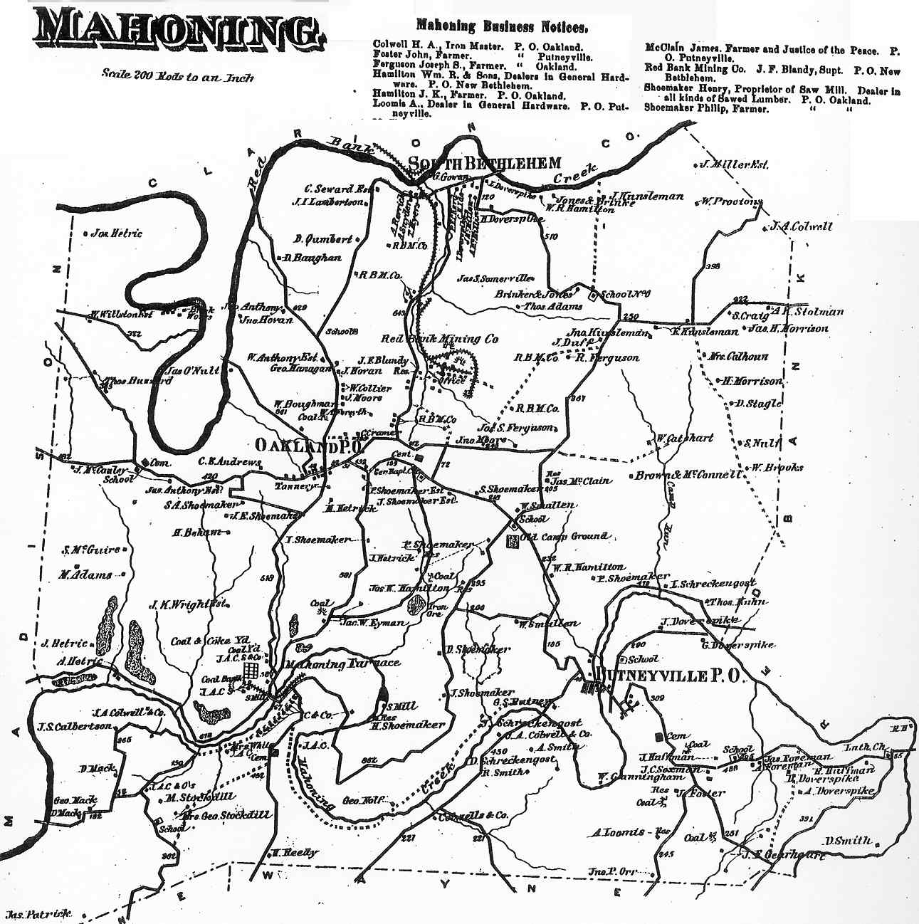
Mahoning Township appears in the 1876 Atlas of Armstrong County, Pennsylvania. [5] Its early history is detailed in Robert Walter Smith's 1883 History of Armstrong County. [6]

Geography

Mahoning Township is located along the northern border of Armstrong County and is bordered by Clarion County to the north across the river.

According to the United States Census Bureau, the township has a total area of 25.2 square miles (65.3 km2), of which 24.8 square miles (64.2 km2) is land and 0.42 square miles (1.1 km2), or 1.73%, is water. [3]

Climate

According to the Köppen Climate Classification system, has a warm-summer humid continental climate, abbreviated "Dfb" on climate maps. The hottest temperature recorded at Putneyville Dam was 103 °F (39.4 °C) on July 17, 1988, while the coldest temperature recorded was −22 °F (−30.0 °C) on January 20, 1994 and February 25, 2015. [7]

Climate data for Putneyville Dam, Pennsylvania, 1991–2020 normals, extremes 1943–present
MonthJanFebMarAprMayJunJulAugSepOctNovDecYear
Record high °F (°C)73
(23)
73
(23)
84
(29)
90
(32)
92
(33)
100
(38)
103
(39)
99
(37)
96
(36)
88
(31)
80
(27)
73
(23)
103
(39)
Mean maximum °F (°C)58.3
(14.6)
59.8
(15.4)
70.8
(21.6)
80.5
(26.9)
86.1
(30.1)
88.9
(31.6)
90.7
(32.6)
89.4
(31.9)
86.9
(30.5)
79.5
(26.4)
69.1
(20.6)
59.9
(15.5)
92.2
(33.4)
Average high °F (°C)34.6
(1.4)
37.6
(3.1)
46.9
(8.3)
61.0
(16.1)
70.8
(21.6)
78.3
(25.7)
82.2
(27.9)
81.1
(27.3)
74.4
(23.6)
62.4
(16.9)
49.8
(9.9)
39.4
(4.1)
59.9
(15.5)
Daily mean °F (°C)25.8
(−3.4)
27.6
(−2.4)
35.7
(2.1)
47.8
(8.8)
58.0
(14.4)
66.3
(19.1)
70.1
(21.2)
69.0
(20.6)
62.1
(16.7)
50.8
(10.4)
40.1
(4.5)
31.2
(−0.4)
48.7
(9.3)
Average low °F (°C)17.0
(−8.3)
17.6
(−8.0)
24.4
(−4.2)
34.6
(1.4)
45.2
(7.3)
54.3
(12.4)
58.1
(14.5)
56.9
(13.8)
49.8
(9.9)
39.1
(3.9)
30.3
(−0.9)
23.1
(−4.9)
37.5
(3.1)
Mean minimum °F (°C)−3.8
(−19.9)
−0.6
(−18.1)
4.8
(−15.1)
20.2
(−6.6)
29.2
(−1.6)
38.8
(3.8)
45.7
(7.6)
44.5
(6.9)
36.9
(2.7)
27.0
(−2.8)
15.8
(−9.0)
7.0
(−13.9)
−6.7
(−21.5)
Record low °F (°C)−22
(−30)
−22
(−30)
−12
(−24)
11
(−12)
17
(−8)
28
(−2)
36
(2)
33
(1)
22
(−6)
15
(−9)
−2
(−19)
−19
(−28)
−22
(−30)
Average precipitation inches (mm)3.37
(86)
2.86
(73)
3.55
(90)
4.08
(104)
4.06
(103)
4.75
(121)
4.74
(120)
3.81
(97)
4.09
(104)
3.29
(84)
3.64
(92)
3.49
(89)
45.73
(1,163)
Average snowfall inches (cm)12.4
(31)
5.1
(13)
5.9
(15)
0.3
(0.76)
0.0
(0.0)
0.0
(0.0)
0.0
(0.0)
0.0
(0.0)
0.0
(0.0)
0.0
(0.0)
1.7
(4.3)
9.1
(23)
34.5
(87.06)
Average extreme snow depth inches (cm)6.9
(18)
6.4
(16)
4.6
(12)
0.2
(0.51)
0.0
(0.0)
0.0
(0.0)
0.0
(0.0)
0.0
(0.0)
0.0
(0.0)
0.0
(0.0)
1.3
(3.3)
3.5
(8.9)
9.7
(25)
Average precipitation days (≥ 0.01 in)14.611.613.314.013.912.911.510.99.911.411.813.6149.4
Average snowy days (≥ 0.1 in)6.14.42.50.40.00.00.00.00.00.01.23.317.9
Source 1: NOAA [8]
Source 2: National Weather Service [7]

Recreation

Pennsylvania State Game Lands Number 137 is located in the northern portion of Mahoning Township, just outside of South Bethlehem near Redbank Creek. [9] [10]

Demographics

Historical population
CensusPop.Note
2010 1,425
2020 1,406−1.3%
2021 (est.)1,393 [2] −0.9%
U.S. Decennial Census [11]

As of the census [12] of 2000, there were 1,502 people, 607 households, and 449 families residing in the township. The population density was 60.5 inhabitants per square mile (23.4/km2). There were 667 housing units at an average density of 26.8 per square mile (10.3/km2). The racial makeup of the township was 99.20% White, 0.27% African American, 0.07% Native American, 0.07% Pacific Islander, and 0.40% from two or more races.

There were 607 households, out of which 30.1% had children under the age of 18 living with them, 63.8% were married couples living together, 6.4% had a female householder with no husband present, and 26.0% were non-families. 22.7% of all households were made up of individuals, and 12.0% had someone living alone who was 65 years of age or older. The average household size was 2.47 and the average family size was 2.90.

The township median age of 40 years was the same as the county median age of 40 years. The distribution by age group was 23.8% under the age of 18, 8.2% from 18 to 24, 25.4% from 25 to 44, 25.0% from 45 to 64, and 17.5% who were 65 years of age or older. The median age was 40 years. For every 100 females there were 97.1 males. For every 100 females age 18 and over, there were 94.2 males.

The median income for a household in the township was $29,934, and the median income for a family was $35,337. Males had a median income of $26,891 versus $16,813 for females. The per capita income for the township was $13,833. About 7.3% of families and 8.1% of the population were below the poverty line, including 12.2% of those under age 18 and 4.9% of those age 65 or over.

Cemeteries

Related Research Articles

<span class="mw-page-title-main">Bethel Township, Armstrong County, Pennsylvania</span> Township in Pennsylvania, United States

Bethel Township is a township in Armstrong County, Pennsylvania, United States. The population was 1,096 at the 2020 census, a decrease from the figure of 1,183 tabulated in 2010.

<span class="mw-page-title-main">Boggs Township, Armstrong County, Pennsylvania</span> Township in Pennsylvania, United States

Boggs Township is a township in Armstrong County, Pennsylvania, United States. The population was 813 at the 2020 census, a decrease from the figure of 936 tabulated in 2010.

<span class="mw-page-title-main">Burrell Township, Armstrong County, Pennsylvania</span> Township in Pennsylvania, United States

Burrell Township is a township in Armstrong County, Pennsylvania, United States and is part of the Pittsburgh metropolitan area. The population was 659 at the 2020 census, a decrease from the figure of 689 tabulated in 2010.

<span class="mw-page-title-main">Cowanshannock Township, Armstrong County, Pennsylvania</span> Township in Pennsylvania, United States

Cowanshannock Township is a township in Armstrong County, Pennsylvania, United States. The population was 2,742 at the 2020 census, a decrease from the figure of 2,899 tabulated in 2010.

<span class="mw-page-title-main">East Franklin Township, Armstrong County, Pennsylvania</span> Township in Pennsylvania, United States

East Franklin Township is a township in Armstrong County, Pennsylvania, United States. The population was 3,821 at the 2020 census, a decrease from the figure of 4,082 tabulated in 2010.

<span class="mw-page-title-main">Kiskiminetas Township, Armstrong County, Pennsylvania</span> Township in Pennsylvania, United States

Kiskiminetas Township is a township in Armstrong County, Pennsylvania, United States. The population was 4,604 at the 2020 census, a decrease from the figure of 4,800 tabulated in 2010, making it the most populous township or borough in the county.

<span class="mw-page-title-main">Kittanning Township, Armstrong County, Pennsylvania</span> Township in Pennsylvania, United States

Kittanning Township is a township in Armstrong County, Pennsylvania, United States. The population was 2,019 at the 2020 census, a decrease from the figure of 2,265 tabulated in 2010.

<span class="mw-page-title-main">Madison Township, Armstrong County, Pennsylvania</span> Township in Pennsylvania, United States

Madison Township is a township in Armstrong County, Pennsylvania, United States. The population was 826 at the 2020 census, an increase over the figure of 820 tabulated in 2010.

<span class="mw-page-title-main">Manor Township, Armstrong County, Pennsylvania</span> Township in Pennsylvania, United States

Manor Township is a township in Armstrong County, Pennsylvania, United States. The population was 4,190 at the 2020 census, a decrease from the figure of 4,227 tabulated in 2010.

<span class="mw-page-title-main">North Buffalo Township, Armstrong County, Pennsylvania</span> Township in Pennsylvania, United States

North Buffalo Township is a township in Armstrong County, Pennsylvania, United States. The population was 2,698 at the 2020 census, a decrease from the figure of 3,011 tabulated in 2010.

<span class="mw-page-title-main">Parks Township, Armstrong County, Pennsylvania</span> Township in Pennsylvania, United States

Parks Township is a township in Armstrong County in the U.S. state of Pennsylvania. The population was 2,471 at the 2020 census, a decrease from 2,744 at the 2010 census.

<span class="mw-page-title-main">Pine Township, Armstrong County, Pennsylvania</span> Township in Pennsylvania, United States

Pine Township is a township that is located in Armstrong County, Pennsylvania, United States. The population was 351 at the time of the 2020 census, a decrease from the figure of 412 that was tabulated in 2010.

<span class="mw-page-title-main">Plumcreek Township, Armstrong County, Pennsylvania</span> Township in Pennsylvania, United States

Plumcreek Township is a township that is located in Armstrong County, Pennsylvania, United States. The population was 2,106 at the time of the 2020 census, a decrease from the figure of 2,375 that was tabulated in 2010.

<span class="mw-page-title-main">Rayburn Township, Armstrong County, Pennsylvania</span> Township in Pennsylvania, United States

Rayburn Township is a township that is located in Armstrong County, Pennsylvania, United States. The population was 1,766 at the time of the 2020 census, a decrease from the figure of 1,907 that was tabulated in 2010.

<span class="mw-page-title-main">Redbank Township, Armstrong County, Pennsylvania</span> Township in Pennsylvania, United States

Redbank Township is a township in Armstrong County, Pennsylvania, United States. The population was 975 at the 2020 census, a decrease from the figure of 1,064 tabulated in 2010.

<span class="mw-page-title-main">South Bend Township, Armstrong County, Pennsylvania</span> Township in Pennsylvania, United States

South Bend Township is a township in Armstrong County, Pennsylvania, United States. The population was 1,010 at the 2020 census, a decrease from the figure of 1,167 tabulated in 2010.

<span class="mw-page-title-main">Sugarcreek Township, Armstrong County, Pennsylvania</span> Township in Pennsylvania, United States

Sugarcreek Township is a township in Armstrong County, Pennsylvania, United States. The population was 1,336 at the 2020 census, a decrease from the figure of 1,539 tabulated in 2010.

<span class="mw-page-title-main">Valley Township, Armstrong County, Pennsylvania</span> Township in Pennsylvania, United States

Valley Township is a township that is located in Armstrong County, Pennsylvania, United States. The population was 654 at the time of the 2020 census, a decrease from the figure of 656 that was tabulated in 2010.

<span class="mw-page-title-main">Washington Township, Armstrong County, Pennsylvania</span> Township in Pennsylvania, United States

Washington Township is a township in Armstrong County, Pennsylvania, United States. The population was 898 at the 2020 census, a decrease from 923 at the 2010 census.

<span class="mw-page-title-main">Wayne Township, Armstrong County, Pennsylvania</span> Township in Pennsylvania, United States

Wayne Township is a township that is located in Armstrong County, Pennsylvania, United States.

References

  1. "2016 U.S. Gazetteer Files". United States Census Bureau. Retrieved Aug 13, 2017.
  2. 1 2 3 Bureau, US Census. "City and Town Population Totals: 2020-2021". Census.gov. US Census Bureau. Retrieved 29 June 2022.
  3. 1 2 "Geographic Identifiers: 2010 Demographic Profile Data (G001): Mahoning township, Armstrong County, Pennsylvania". U.S. Census Bureau, American Factfinder. Archived from the original on February 10, 2020. Retrieved August 1, 2013.
  4. "National Register Information System". National Register of Historic Places . National Park Service. July 9, 2010.
  5. "Atlas of Armstrong County Pennsylvania, page 52". Pomeroy, Whitman & Co. 1876. Retrieved 9 November 2018.
  6. Robert Walter Smith (1883). "History of Armstrong County Pennsylvania, Chapter 15, page 346". Chicago: Waterman, Watkins. Retrieved 7 November 2018.
  7. 1 2 "NOAA Online Weather Data – NWS Pittsburgh". National Weather Service. Retrieved August 7, 2023.
  8. "U.S. Climate Normals Quick Access – Station: Putneyville 2 SE Dam, PA". National Oceanic and Atmospheric Administration. Retrieved August 7, 2023.
  9. https://viewer.nationalmap.gov/advanced-viewer/ The National Map, retrieved 22 October 2018
  10. Pennsylvania State Game Lands Number 137, retrieved 23 October 2018
  11. "Census of Population and Housing". Census.gov. Retrieved June 4, 2016.
  12. "U.S. Census website". United States Census Bureau . Retrieved 2008-01-31.
  13. "Baptist Narrows Cemetery". Geographic Names Information System . United States Geological Survey, United States Department of the Interior.
  14. "Colwell Cemetery". Geographic Names Information System . United States Geological Survey, United States Department of the Interior.
  15. "Deanville Cemetery". Geographic Names Information System . United States Geological Survey, United States Department of the Interior.
  16. "Mount Zion Cemetery". Geographic Names Information System . United States Geological Survey, United States Department of the Interior.
  17. "Oakland Cemetery". Geographic Names Information System . United States Geological Survey, United States Department of the Interior.
  18. "Putneyville Cemetery". Geographic Names Information System . United States Geological Survey, United States Department of the Interior.
  19. "Smullin Cemetery". Geographic Names Information System . United States Geological Survey, United States Department of the Interior.

40°57′26″N79°20′38″W / 40.95722°N 79.34389°W / 40.95722; -79.34389