Worthington, Pennsylvania

Last updated

Worthington, Pennsylvania
Worthington, Pennsylvania.jpg
Worthington-West Franklin Municipal Complex
Armstrong County Pennsylvania Incorporated and Unincorporated areas Worthington Highlighted.svg
Location of Worthington in Armstrong County, Pennsylvania.
USA Pennsylvania location map.svg
Red pog.svg
Worthington
Coordinates: 40°50′17″N79°37′58″W / 40.83806°N 79.63278°W / 40.83806; -79.63278
Country United States
State Pennsylvania
County Armstrong
Settled1811
Incorporated1855
Government
  TypeBorough council
Area
[1]
  Total0.69 sq mi (1.78 km2)
  Land0.69 sq mi (1.78 km2)
  Water0.00 sq mi (0.00 km2)
Elevation
1,120 ft (340 m)
Population
 (2020)
  Total594
  Estimate 
(2019) [2]
589
  Density856.10/sq mi (330.71/km2)
Time zone UTC-5 (Eastern (EST))
  Summer (DST) UTC-4 (EDT)
Zip code
16262
FIPS code42-86560

Worthington is a borough in Armstrong County, Pennsylvania, United States. The population was 594 at the 2020 census. [3] [4]

Contents

History

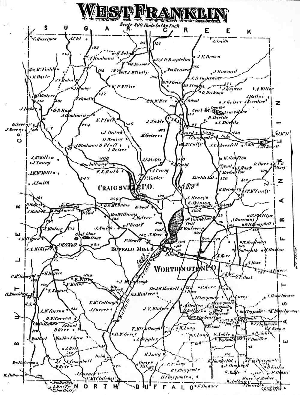
Worthington was laid out on a tract of land called Mt. Lorenzo by Judge James Barr in 1843–1844. He chose the location due to the nearby junction of two important early stage coach routes, the east–west route from Indiana, Pennsylvania, to Butler, and the north–south route from Freeport to Emlenton. It was incorporated as a borough in 1855. As the village grew into a town it variously relied upon farming and light manufacturing for its income. During the 1970s most manufacturing ceased. Agriculture is still important to the region, and a few light tool and die firms survive. The region also features coal, natural gas, and mineral extraction. In the 19th century an iron furnace and woolen mill were the main industrial operations, both owned and operated by Peter Graff I.

The town's first settlers were a mix of eastern Pennsylvanians and newly arrived immigrants of Scotch-Irish, German and English background. Other ethnic groups would arrive in the early 20th century in small numbers. Other later industries included tile block and clay drain pipe manufacturing, aluminum ladder and specialty tool and die production, limestone mining, and underground mushroom farming. The town hosts four Protestant churches, a community park, several civic organizations (including a public library), and a community center and municipal complex housed in the former Junior/Senior High School. The fire hall serves both Worthington borough and West Franklin Township.

The joint municipalities of Worthington borough and West Franklin Township (which includes the former villages of Craigsville, Yellowdog, and Laird's Crossing) have cooperated in many areas including public utilities (water and sewage), and both municipalities are often colloquially referred to as Worthington - sharing the same zip code of 16262. The former high school is actually located outside of Worthington borough and was officially called Worthington-West Franklin Jr./Sr. High School. The mascot for the school was the Bison, and the school colors were green and white. The school closed around 1984, and the students began attending Kittanning High School, which also closed in 2015 (along with Ford City and Elderton high schools) in order to form Armstrong High School.

Worthington P.O. appears in the 1876 Atlas of Armstrong County, Pennsylvania. [5]

Geography

Worthington is located in western Armstrong County at 40°50′17″N79°37′58″W / 40.838123°N 79.632685°W / 40.838123; -79.632685 . [6] U.S. Route 422, the four-lane Benjamin Franklin Highway, passes through the borough south of its center, leading east 7 miles (11 km) to Kittanning and west 15 miles (24 km) to Butler. The borough extends west into the valley of Buffalo Creek, a tributary of the Allegheny River.

According to the United States Census Bureau, the borough has a total area of 0.69 square miles (1.8 km2), all land. [3]

Demographics

Historical population
CensusPop.Note
1860 213
1870 2161.4%
1880 186−13.9%
1890 24632.3%
1900 39861.8%
1910 4369.5%
1920 4400.9%
1930 66150.2%
1940 600−9.2%
1950 80033.3%
1960 772−3.5%
1970 8165.7%
1980 760−6.9%
1990 713−6.2%
2000 7789.1%
2010 594−23.7%
2019 (est.)589 [2] −0.8%
Sources: [7] [8] [9]

As of the 2000 census, [8] there were 778 people, 307 households, and 212 families residing in the borough. The population density was 1,380.4 inhabitants per square mile (533.0/km2). There were 319 housing units at an average density of 566.0 per square mile (218.5/km2). The racial makeup of the borough was 99.10% |White, 0.26% African American, 0.13% Asian, 0.13% from other races, and 0.39% from two or more races. Hispanic or Latino of any race were 0.26% of the population.

There were 307 households, out of which 29.3% had children under the age of 18 living with them, 56.7% were married couples living together, 9.4% had a female householder with no husband present, and 30.9% were non-families. 26.4% of all households were made up of individuals, and 12.1% had someone living alone who was 65 years of age or older. The average household size was 2.43 and the average family size was 2.91.

The borough median age of 40 years was the same as the county median age. The distribution by age group was 22.2% under the age of 18, 7.8% from 18 to 24, 26.6% from 25 to 44, 26.9% from 45 to 64, and 16.5% who were 65 years of age or older. The median age was 40 years. For every 100 females there were 90.7 males. For every 100 females age 18 and over, there were 92.7 males.

The median income for a household in the borough was $31,000, and the median income for a family was $37,292. Males had a median income of $27,443 versus $21,818 for females. The per capita income for the borough was $15,122. About 2.9% of families and 9.2% of the population were below the poverty line, including 7.0% of those under age 18 and 7.8% of those age 65 or over.

Related Research Articles

<span class="mw-page-title-main">Armstrong County, Pennsylvania</span> County in Pennsylvania, United States

Armstrong County is a county in the Commonwealth of Pennsylvania. As of the 2020 census, the population was 65,558. The county seat is Kittanning. The county was organized on March 12, 1800, from parts of Allegheny, Westmoreland and Lycoming Counties. It was named in honor of John Armstrong, who represented Pennsylvania in the Continental Congress and served as a major general during the Revolutionary War.

<span class="mw-page-title-main">Applewold, Pennsylvania</span> Borough in Pennsylvania, United States

Applewold is a borough in Armstrong County, Pennsylvania, United States. The population was 334 at the 2020 census.

<span class="mw-page-title-main">Dayton, Pennsylvania</span> Borough in Pennsylvania, United States

Dayton is a borough in Armstrong County, Pennsylvania, United States. The population was 549 at the 2020 census.

<span class="mw-page-title-main">East Franklin Township, Armstrong County, Pennsylvania</span> Township in Pennsylvania, United States

East Franklin Township is a township in Armstrong County, Pennsylvania, United States. The population was 3,821 at the 2020 census, a decrease from the figure of 4,082 tabulated in 2010.

<span class="mw-page-title-main">Elderton, Pennsylvania</span> Borough in Pennsylvania, United States

Elderton is a borough in Armstrong County, Pennsylvania, United States. The population was 334 at the 2020 census.

<span class="mw-page-title-main">Ford City, Pennsylvania</span> Borough in Pennsylvania, United States

Ford City is a borough in Armstrong County, Pennsylvania, United States, 40 miles (64 km) northeast of Pittsburgh along the east bank of the Allegheny River and 4 miles (6 km) south of Kittanning, the county seat. The population was 2,859 at the 2020 census. It is part of the Pittsburgh metropolitan area.

<span class="mw-page-title-main">Kittanning, Pennsylvania</span> Borough in Pennsylvania, United States

Kittanning is a borough in and the county seat of Armstrong County, Pennsylvania, United States. It is situated 36 miles (58 km) northeast of Pittsburgh, along the east bank of the Allegheny River. The population was 3,921 at the 2020 census.

<span class="mw-page-title-main">Kittanning Township, Armstrong County, Pennsylvania</span> Township in Pennsylvania, United States

Kittanning Township is a township in Armstrong County, Pennsylvania, United States. The population was 2,019 at the 2020 census, a decrease from the figure of 2,265 tabulated in 2010.

<span class="mw-page-title-main">Manor Township, Armstrong County, Pennsylvania</span> Township in Pennsylvania, United States

Manor Township is a township in Armstrong County, Pennsylvania, United States. The population was 4,190 at the 2020 census, a decrease from the figure of 4,227 tabulated in 2010.

<span class="mw-page-title-main">Rayburn Township, Pennsylvania</span> Township in Pennsylvania, United States

Rayburn Township is a township that is located in Armstrong County, Pennsylvania, United States. The population was 1,766 at the time of the 2020 census, a decrease from the figure of 1,907 that was tabulated in 2010.

<span class="mw-page-title-main">Rural Valley, Pennsylvania</span> Borough in Pennsylvania, United States

Rural Valley is a borough in Armstrong County, Pennsylvania, United States. The population was 826 at the 2020 census.

<span class="mw-page-title-main">South Bethlehem, Pennsylvania</span> Borough in Pennsylvania, United States

South Bethlehem is a borough in Armstrong County, Pennsylvania, United States. The population was 489 at the 2020 census.

<span class="mw-page-title-main">West Franklin Township, Pennsylvania</span> Township in Pennsylvania, United States

West Franklin Township is a township in Armstrong County, Pennsylvania, United States. The population was 1,709 at the 2020 census, a decline from the figure of 1,853 tabulated in 2010.

<span class="mw-page-title-main">West Kittanning, Pennsylvania</span> Borough in Pennsylvania, United States

West Kittanning is a borough in Armstrong County, Pennsylvania, United States. The population was 1,192 at the 2020 census.

<span class="mw-page-title-main">Homeacre-Lyndora, Pennsylvania</span> Census-designated place in Pennsylvania, United States

Homeacre-Lyndora is a census-designated place (CDP) in Butler County, Pennsylvania, United States. The population was 6,906 at the 2010 census.

<span class="mw-page-title-main">Summit Township, Butler County, Pennsylvania</span> Township in Pennsylvania, United States

Summit Township is a township that is located in Butler County, Pennsylvania, United States. The population was 4,503 at the time of the 2020 census.

<span class="mw-page-title-main">New Bethlehem, Pennsylvania</span> Borough in Pennsylvania, United States

New Bethlehem is a borough in Clarion County, Pennsylvania, United States. The population was 979 at the 2020 census. The borough is situated at the southwestern corner of the Pennsylvania Wilds Conservation Landscape. Its main street, PA Route 28-66, is a major thoroughfare between the Pittsburgh metropolitan region and northcentral Pennsylvania.

<span class="mw-page-title-main">Mahaffey, Pennsylvania</span> Borough in Pennsylvania, United States

Mahaffey is a borough in Clearfield County, Pennsylvania, United States. The population was 329 at the 2020 census.

<span class="mw-page-title-main">Armstrong Township, Indiana County, Pennsylvania</span> Township in Pennsylvania, United States

Armstrong Township is a township in Indiana County, Pennsylvania, United States. The township was named after General Armstrong, who commanded the celebration against Kittanning. The population was 2,786 at the 2020 census. The township includes the communities of Crete, Miller, Parkwood, Tannery Village, and Thomas. It surrounds the separately incorporated borough of Shelocta.

<span class="mw-page-title-main">Armstrong School District (Pennsylvania)</span> School district in Pennsylvania

The Armstrong School District is a large, public school district which encompasses approximately 437 square miles (1,130 km2). The district is one of the 500 public school districts of Pennsylvania. In Armstrong County, Pennsylvania, Armstrong School District covers the Boroughs of Applewold, Atwood, Dayton, Elderton, Ford City, Ford Cliff, Kittanning, Manorville, Rural Valley, West Kittanning and Worthington and the Townships of Bethel Township, Boggs Township, Burrell Township, Cadogan Township, Cowanshannock Township, East Franklin Township, Kittanning Township, Manor Township, North Buffalo Township, Pine Township, Plumcreek Township, Rayburn Township, South Bend Township, Valley Township, Washington Township, Wayne Township and West Franklin Township. In Indiana County, Pennsylvania, the district includes the Borough of Smicksburg and West Mahoning Township. According to 2000 federal census data, it served a resident population of 44,970. By 2010, the District's population had declined to 43,301 people. In 2009, Armstrong School District residents' per capita income was $15,449, while the median family income was $36,907.

References

  1. "2019 U.S. Gazetteer Files". United States Census Bureau. Retrieved July 28, 2020.
  2. 1 2 "Population and Housing Unit Estimates". United States Census Bureau. May 24, 2020. Retrieved May 27, 2020.
  3. 1 2 "Geographic Identifiers: 2010 Demographic Profile Data (G001): Worthington borough, Pennsylvania". U.S. Census Bureau, American Factfinder. Archived from the original on February 12, 2020. Retrieved July 31, 2013.
  4. "Explore Census Data".
  5. "Atlas of Armstrong County Pennsylvania, page 86". Pomeroy, Whitman & Co. 1876. Retrieved November 9, 2018.
  6. "US Gazetteer files: 2010, 2000, and 1990". United States Census Bureau. February 12, 2011. Retrieved April 23, 2011.
  7. "Census of Population and Housing". U.S. Census Bureau. Retrieved December 11, 2013.
  8. 1 2 "U.S. Census website". United States Census Bureau . Retrieved January 31, 2008.
  9. "Incorporated Places and Minor Civil Divisions Datasets: Subcounty Resident Population Estimates: April 1, 2010 to July 1, 2012". Population Estimates. U.S. Census Bureau. Archived from the original on June 11, 2013. Retrieved December 11, 2013.