Cowanshannock Creek

Last updated
Cowanshannock Creek
Location
Country United States
Physical characteristics
Source 
  coordinates 40°49′34″N79°10′32″W / 40.8261758°N 79.1755926°W / 40.8261758; -79.1755926
Mouth  
  coordinates
40°51′04″N79°30′28″W / 40.8511753°N 79.5078224°W / 40.8511753; -79.5078224
  elevation
787 ft (240 m)
Basin features
River system Allegheny River

Cowanshannock Creek (the eastern section is sometimes referred to as the North Branch Cowanshannock Creek) is a tributary of the Allegheny River in Armstrong and Indiana counties, Pennsylvania in the United States. [1]

Contents

Course

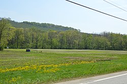
Creek floodplain in Valley Township Cowanshannock Creek floodplain, Valley Township.jpg
Creek floodplain in Valley Township

Cowanshannock Creek rises in South Mahoning Township in Indiana County, Pennsylvania. It flows west into Armstrong County meandering through Cowanshannock Township, the borough of Rural Valley, Valley Township, Manor Township, and Rayburn Township. The stream joins the Allegheny River on its right bank at the community of Gosford, approximately 3 miles (4.8 km) northeast of Kittanning.

Tributaries

(Mouth at the Allegheny River)

See also

Related Research Articles

<span class="mw-page-title-main">Bethel Township, Armstrong County, Pennsylvania</span> Township in Pennsylvania, United States

Bethel Township is a township in Armstrong County, Pennsylvania, United States. The population was 1,096 at the 2020 census, a decrease from the figure of 1,183 tabulated in 2010.

<span class="mw-page-title-main">Cowanshannock Township, Armstrong County, Pennsylvania</span> Township in Pennsylvania, United States

Cowanshannock Township is a township in Armstrong County, Pennsylvania, United States. The population was 2,742 at the 2020 census, a decrease from the figure of 2,899 tabulated in 2010.

<span class="mw-page-title-main">Manor Township, Armstrong County, Pennsylvania</span> Township in Pennsylvania, United States

Manor Township is a township in Armstrong County, Pennsylvania, United States. The population was 4,190 at the 2020 census, a decrease from the figure of 4,227 tabulated in 2010.

<span class="mw-page-title-main">Rayburn Township, Pennsylvania</span> Township in Pennsylvania, United States

Rayburn Township is a township that is located in Armstrong County, Pennsylvania, United States. The population was 1,766 at the time of the 2020 census, a decrease from the figure of 1,907 that was tabulated in 2010.

<span class="mw-page-title-main">Valley Township, Armstrong County, Pennsylvania</span> Township in Pennsylvania, United States

Valley Township is a township that is located in Armstrong County, Pennsylvania, United States. The population was 654 at the time of the 2020 census, a decrease from the figure of 656 that was tabulated in 2010.

<span class="mw-page-title-main">Kiskiminetas River</span> River in Pennsylvania, United States

The Kiskiminetas River is a tributary of the Allegheny River, approximately 27 miles (43 km) long, in Western Pennsylvania in the United States. The region stretching from the northern side of Harmar Township, Pennsylvania to the Kiskiminetas towns is often referred to by the locals as the Alle-Kiski Valley after the rivers.

East Sandy Creek is a tributary of the Allegheny River in Northwestern Pennsylvania in the United States.

<span class="mw-page-title-main">Redbank Creek (Pennsylvania)</span> River in Pennsylvania, United States

Redbank Creek is a tributary of the Allegheny River in Clarion, Armstrong, and Jefferson counties, Pennsylvania in the United States.

<span class="mw-page-title-main">Mahoning Creek (Allegheny River tributary)</span> River in the United States

Mahoning Creek is a tributary of the Allegheny River in Pennsylvania in the United States.

Buffalo Creek is a tributary of the Allegheny River in Armstrong and Butler counties, Pennsylvania in the United States.

North Fork Creek is a tributary of Redbank Creek in northwest Pennsylvania in the United States. It is formed by the confluence of Muddy Run and Williams Run in Polk Township, Jefferson County.

<span class="mw-page-title-main">Sandy Lick Creek</span>

Sandy Lick Creek is a tributary of Redbank Creek in northwest Pennsylvania in the United States.

Little Sandy Creek is a tributary of Redbank Creek, approximately 32.7 mi (52.6 km) long, in northwest Pennsylvania in the United States.

<span class="mw-page-title-main">Crooked Creek (Allegheny River tributary)</span> River in the United States

Crooked Creek is a tributary of the Allegheny River in both Armstrong and Indiana counties in the U.S. state of Pennsylvania.

<span class="mw-page-title-main">Pine Creek (Allegheny River tributary)</span> River in the United States

Pine Creek is a tributary of the Allegheny River located in Allegheny County in the U.S. state of Pennsylvania.

Deer Creek is a tributary of the Allegheny River located in both Allegheny and Butler counties in the U.S. state of Pennsylvania.

The following table lists all the named streams that flow in Armstrong County. For each stream, the name, coordinate of the source, name of the stream it flows into, coordinate of the confluence, and political subdivision in which the confluence is located are given.

The Pennsylvania State Game Lands Number 25 are Pennsylvania State Game Lands in Elk County in Pennsylvania in the United States providing hunting, bird watching, and other activities.
References

  1. "Cowanshannock Creek". Geographic Names Information System . United States Geological Survey, United States Department of the Interior . Retrieved 2010-11-15.
  2. "Craigs Run". Geographic Names Information System . United States Geological Survey, United States Department of the Interior . Retrieved 2018-11-23.
  3. "Long Run". Geographic Names Information System . United States Geological Survey, United States Department of the Interior . Retrieved 2018-11-23.
  4. "Mill Run". Geographic Names Information System . United States Geological Survey, United States Department of the Interior . Retrieved 2010-11-18.
  5. "Spra Run". Geographic Names Information System . United States Geological Survey, United States Department of the Interior . Retrieved 2010-11-18.
  6. "Huskins Run". Geographic Names Information System . United States Geological Survey, United States Department of the Interior . Retrieved 2010-11-18.
  7. "South Branch Cowanshannock Creek". Geographic Names Information System . United States Geological Survey, United States Department of the Interior . Retrieved 2010-11-18.
  8. "Spruce Run". Geographic Names Information System . United States Geological Survey, United States Department of the Interior . Retrieved 2010-11-18.
Map all coordinates using: OpenStreetMap