
Parker is a city located in Armstrong County, Pennsylvania, United States. It is in the extreme northwestern portion of the county. The population was 840 at the 2010 census. The city was named for Judge John Parker, a lead surveyor of Lawrenceburg and founder/owner of Parker's Landing, the two villages combined to create Parker.
Allegheny Township is a township in Butler County, Pennsylvania, United States. The population was 641 at the 2010 census.

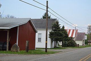
Foxburg is a borough in Clarion County, Pennsylvania, United States. It is located along the east bank of the Allegheny River, about 2 miles (3 km) north of the mouth of the Clarion River. As of the 2010 census it had a population of 183.

Warren is a city in Warren County, Pennsylvania, United States, located along the Allegheny River. The population was 9,710 at the 2010 census. It is the county seat of Warren County. It is home to the headquarters of the Allegheny National Forest and the Cornplanter State Forest. It is also the headquarters for the Chief Cornplanter Council, the oldest continuously chartered Boy Scouts of America Council, and the catalog company Blair. Warren is the principal city of the Warren, PA Micropolitan Statistical Area.
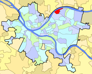
Lawrenceville is one of the largest neighborhood areas in Pittsburgh in the U.S. state of Pennsylvania. It is located northeast of downtown, and like many of the city's riverfront neighborhoods, it has an industrial past. The city considers Lawrenceville three neighborhoods, Upper Lawrenceville, Central Lawrenceville, and Lower Lawrenceville, but these distinctions have little practical effect. Accordingly, Lawrenceville is almost universally treated as being a single large neighborhood.

The Fort Duquesne Bridge is a steel bowstring arch bridge that spans the Allegheny River in Pittsburgh, Pennsylvania. It was colloquially referred to as "The Bridge to Nowhere". It was constructed from 1958-1963 by PennDOT, and opened for traffic October 17, 1969 with its predecessor Manchester Bridge closing that same day. The bridge was given the name "The Bridge to Nowhere" because the main span was finished in 1963, but due to delays in acquiring right of ways for the northern approach ramps, it did not connect on the north side of the Allegheny River. The total cost was budgeted at $5 million in 1962. The lack of approach ramps meant the bridge ended in midair, rendering it useless. The northwestern ramps were completed in 1969, allowing access to Pennsylvania Route 65. The northeastern ramps were completed in 1986, with the construction of the northern section of Interstate 279 which runs through Downtown Pittsburgh's Golden Triangle and north towards Interstate 79. The bridge touches down halfway between Heinz Field and PNC Park Baseball Stadium on the City's North Shore.
King Island is a 35.7-acre (144,000 m2) alluvial island in the upper Allegheny River. It is located in Harmony Township, Forest County, Pennsylvania, and is part of the Allegheny Islands Wilderness in Allegheny National Forest.

The Kittanning Citizens Bridge is a through truss bridge spanning the Allegheny River at Kittanning in the U.S. state of Pennsylvania. Constructed in 1932, the bridge carries vehicles and pedestrians between Kittanning and West Kittanning.

The Allegheny Reservoir is a reservoir along the Allegheny River in Pennsylvania and New York, USA. It was created in 1965 by the construction of the Kinzua Dam along the river.
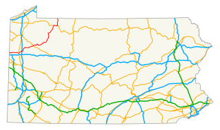
U.S. Route 62 is a signed north-south U.S. Highway in Pennsylvania, which runs diagonally southwest-northeast through the industrial northwestern part of the state. Although initial portions of the route opened in 1926 in other areas of the country, U.S. 62 was not designated in the commonwealth until 1932. The highway connects the small cities of Sharon, Franklin, Oil City, and Warren to larger markets, such as Youngstown, Ohio and Buffalo, New York.
The C.L. Schmitt Bridge is a truss bridge that carries vehicular traffic across the Allegheny River between New Kensington and East Deer Township, Pennsylvania in the United States.

The Judge J. Frank Graff Bridge is a truss bridge that carries U.S. Route 422 (US 422) and Pennsylvania Route 28 (PA 28) across the Allegheny River. It connects Manor Township and North Buffalo Township, Pennsylvania. It was constructed in 1974 as part of a freeway bypass of Kittanning, Pennsylvania. The structure is named for Frank Graff, an Armstrong County Court of Common Pleas Judge who later rose to become a member of the Pennsylvania Superior Court.
The Ford City Veterans Bridge is a girder bridge connecting Ford City and North Buffalo Township, Pennsylvania. It was constructed in 2000 to replace a 1914 structure. The structure was one of the first in the nation to use a new type of high-performance, weather resistant steel.
The Kennerdell Bridge is a girder bridge connecting Rockland Township and Clinton Township in Venango County, Pennsylvania that serves the tiny village of Kennerdell. Originally, a 1907 truss bridge stood on this site. It was rehabilitated in 1981, but ultimately replaced in 2000. Only about 250 cars use the bridge each day
The Petroleum Street Bridge is a girder bridge connecting the North Side and South Side neighborhoods of Oil City, Pennsylvania and crosses the Allegheny River. The bridge sits just downstream from the confluence of Oil Creek and the Allegheny River. The 1995 structure carries two lanes of U.S. Route 62 and was built during a decade of major refurbishments of Upper Allegheny crossings. Previously, a 1910 truss bridge stood on the site; this structure replaced an earlier wooden bridge.
The Hunter Station Bridge is a truss bridge that carries U.S. Route 62 (US 62) across the Allegheny River in rural Tionesta Township in Forest County, Pennsylvania. The structure was named for a railroad stop on the long defunct Ridgway & Oil City Railroad.
The Tionesta Bridge is a girder bridge that carries U.S. Route 62 and Pennsylvania Route 36 across the Allegheny River in rural Forest County, Pennsylvania. The borough of Tionesta on the east bank of the river is connected with an unpopulated section of Tionesta Township on the west bank.


