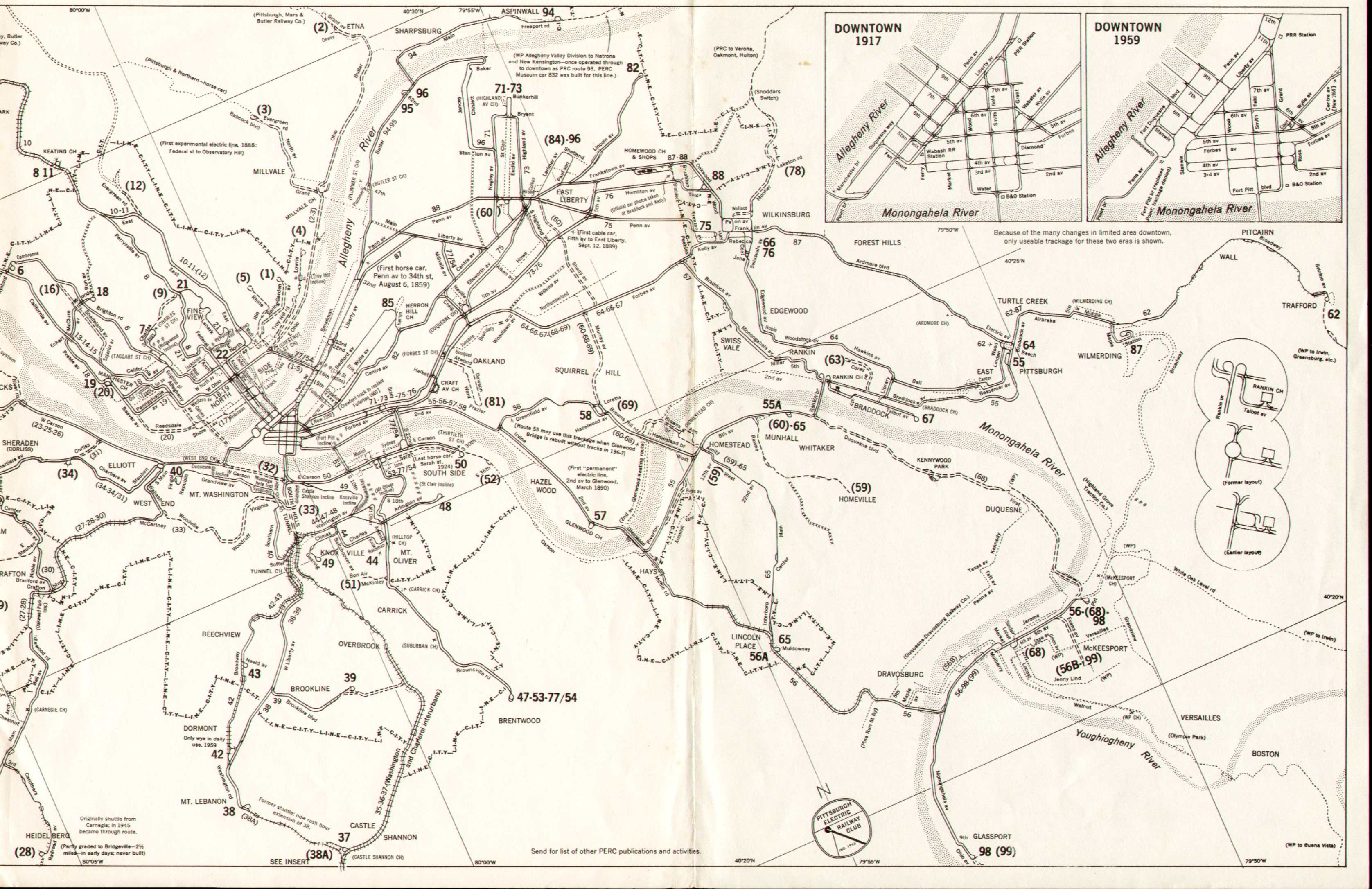
Pittsburgh Railways operated 68 streetcar routes. The table below lists their dates of operation.
| No. | Route | opened | closed / renamed | notes |
|---|---|---|---|---|
| 1 | Spring Garden | by 1915 [1] | Oct 6, 1957 [2] | PCC from 1940, closed (low traffic) [3] |
| 2 | Etna | by 1907 | Sep 2, 1952 [2] | Interchange between PRCo and Pittsburgh and Butler Street Railway from 1907 until 1931. PCC from 1938, closed (state took land for PA Route 28) [3] |
| 3 | Millvale | by 1915 [1] | Sep 2, 1952 [2] | PCC from 1938, closed (state took land for PA 28 as with the 2) [3] |
| 4 | Troy Hill | by 1915 [1] | Jul 7, 1957 [2] | Loop was in Troy Hill at Lowrie and Roessler Streets. PCC from 1940, closed (street paving / low traffic) [3] |
| 5 | Troy Hill (Lowrie and Gardner) | by 1916 [4] | closed; number reassigned | |
| 5 | Troy Hill via North Avenue | by 1918 [5] | closed; number reassigned | |
| 5 | Spring Hill | Oct 6, 1957 [2] | PCC from 1946, closed (street paving / low traffic) [3] | |
| 6 | Brighton Road | by 1915 | Jan 26, 1966 | In 1915 timetable. [1] PCC from 1938. Became 6/13. [6] |
| 6/13 | Brighton Road via Emsworth | Sep 1965 | Dec 31, 1965 | Cut back to become 6/14 Brighton Avalon [7] when the Avalon bridge (Spruce Run Viaduct) and Ben Avon Bridge (Ravine Street Viaduct), built in 1905, were closed to trolleys due to weight restrictions. [8] |
| 6/14 | Brighton Avalon | Dec 1965 | Apr 30, 1966 [9] | |
| 7 | Charles Street | by 1915 [1] | Sep 1, 1961 [6] | |
| 8 | Perrysville Avenue | by 1899 [10] | Sep 4, 1965 [6] | |
| 9 | Charles Street Transfer | by 1916 [4] | September 14, 1951 [11] | Double-end shuttle (no loop or wye) between the 7 Charles Street and 21 Fineview services. |
| 10 | West View and Bellevue | by 1915 [1] | Sep 4, 1965 [6] | Formed a loop with 15 Bellevue. 10 West View was counterclockwise as far as West View. |
| 11 | East Street and Madison Avenue | by 1915 [1] | Sep 4, 1965 [6] | Short turn of the 10 |
| 12 | Evergreen Road via East Street | by 1908 | February 1954 [12] | Interchange between PRCo and Pittsburgh, Harmony, Butler and New Castle Railway from 1908 until 1931. Double-end shuttle (no loop or wye). |
| 13 | Emsworth | by 1915 [1] | Sep 3, 1966 [6] | became 6/13 |
| 14 | Avalon | by 1915 [1] | Apr 30, 1966 [6] | Short turn of the 13. Became the 6/14 when 6/13 was cut back to Avalon loop. |
| 15 | Bellevue and West View | by 1915 [1] | Sep 4, 1965 [6] | Formed a loop with 10 West View. 15 Bellevue was clockwise as far as West View. |
| 16 | Shadeland [13] | |||
| 17 | Reedsdale | |||
| 18 | Woods Run via Union Line | by 1915 [1] | Sep 1, 1961 [6] | |
| 19 | Western Avenue | by 1915 [1] | Sep 1, 1961 [6] | |
| 20 | Rebecca (later renamed Reedsdale) | by 1915 [1] | October 14, 1951 [2] | PCC from 1942. Closed (loss of Manchester Bridge ramp) [3] |
| 21 | Fineview | Mar 31, 1908 [14] | Apr 30, 1966 [9] [6] | Originally called the "Nunnery Hill" line. Maximum grade of 12.24% was steepest grade on system. Inbound route duplicated 8 Perrysville Avenue. Initially closed without bus replacement due to grades and narrow streets on outbound route. [11] Later duplicated by PAT bus route 11 |
| 22 | Crosstown | by 1918 [5] | Jul 4, 1964 [6] | From North Side (formerly Allegheny City) business area to 6th/5th in downtown. |
| 23 | Coraopolis – Sewickley | by 1916 [4] | Jun 22, 1952 [2] | Crossed the Ohio River 3 times, twice to reach and leave Neville Island, then over the entire channel between Coraopolis and Sewickley [11] |
| 24 | Schoenville | 1919 [15] | May 9, 1952 [16] | Isolated from main network on January 26, 1920 with the closing of O'Donovan's Bridge due to structural deficiencies. Operated with a single car (4344) that was maintained on the street at one end of the line until closure. |
| 25 | McKees Rocks – Island Avenue | by Dec 1, 1910 [17] | Jun 21, 1959 [2] | |
| 26 | McKees Rocks – West Park | by 1915 [1] | Jun 21, 1959 [2] | |
| 27 | Carnegie and Heidelberg | by Dec 1, 1910 [17] | Jun 21, 1959 [2] | |
| 28 | Crafton Junction | by 1916 [4] | Jun 21, 1959 [2] | |
| 29 | Crafton and Thornburg | by 1915 [1] | 15 November 1952 [18] | |
| 30 | Crafton and Ingram | by 1915 [1] | Jun 21, 1959 [2] | |
| 31 | Ingram–Sheraden | 1897[ citation needed ] | 1950 [13] | The Pittsburgh, Crafton and Mansfield (Carnegie) Railway was chartered to build a streetcar line through Sheraden in 1897. The line (combined in 1950 with Route 34 to form the 31/34 Elliott-Ingram) closed when the Point Bridge closed as the replacement did not have tracks. |
| 32 | Elliott | by 1915 [1] | June 6, 1953 [12] | Double-ended shuttle. Later known as 32 P&LE Transfer due to line's eastern terminus at P&LE Station. Track and wire remained intact until 1956 for nonrevenue use. |
| 33 | Mount Washington via Point | by 1915 [1] | by 1952 [13] | Double-ended shuttle |
| 34 | Elliott | by 1916 [4] | Jun 20, 1959 [19] [20] | Became 31/34 Elliott-Ingram in 1950 [3] |
| 35 | Elliott (Lorenz Avenue only) | by 1916 [4] | ||
| 35 | Castle Shannon – Library Loop | Via Overbrook. Truncation of Charleroi interurban line. Direct ancestor of current Silver Line - Library | ||
| 36 | Fair Haven | by 1916 [4] | ||
| 36 | Castle Shannon – Drake Loop | Via Overbrook. Truncation of Washington interurban line. Direct ancestor of current Blue Line to South Hills Village. Drake Loop service ended September 4, 1999 [21] | ||
| 37 | Fair Haven and Castle Shannon | by 1916 [4] | Best known by later designation 37 Castle Shannon. Ran via Overbrook; nucleus of modern Blue Line | |
| 38 | Mount Lebanon and Castle Shannon | 1915 [22] | May 25, 1963 [6] | Outer end beyond W. Liberty Ave. became part of 42/38 Mt. Lebanon-Beechview |
| 38A | Mount Lebanon Castle Shannon Shuttle | A double end shuttle between Castle Shannon and Clearview loop. Replaced by a rush hour extension of 38 Mount Lebanon. [13] | ||
| 39 | Brookline | 1905 [22] | Sep 3, 1966 [6] | South along West Liberty Avenue and then turned east along Brookline Blvd. [13] Originally extended as far as Saw Mill Run, cut back in 1906. [22] |
| 40 | Mount Washington via Tunnel | by 1915 [1] | Sep 3, 1966 [6] | |
| 41 | Mount Washington Short Line | by 1915 [1] | ||
| 42 | Dormont | by 1915 [1] | became 42/38 Mt. Lebanon-Beechview when 38 trackage on West Liberty Avenue abandoned. | |
| 42/38 | Mt. Lebanon-Beechview | Formed from 42 Dormont and southern end of 38 Mount Lebanon. Direct ancestor of Red Line | ||
| 43 | Neeld Avenue | by 1916 [4] | Short turn of the 42 and 42/38 | |
| 44 | Knoxville via Tunnel | by 1915 [1] | circa 1968 | Signed as 44 Knoxville-Pa. Sta. for its northern terminus. Combined with route 48 in late 1960s |
| 44/48 | Knoxville-Arlington | circa 1968 | Nov 14, 1971 [2] | |
| 45 | by 1916 [4] | |||
| 46 | Brownsville Road | by 1915 [1] | Sep 30, 1946 | Became 49 Beltzhoover |
| 47 | McKinley and Southern | by 1916 [4] | ||
| 47 | Carrick via Tunnel | by 1915 [1] | Mar 30, 1968 | Rush-hour variant of Route 53; became the new route for the 53 itself in 1968 |
| 48 | Arlington | by 1915 [1] | circa 1968 | Combined with 44 Knoxville circa 1968. Portions became part of 49 Arlington-Warrington in 1971 |
| 49 | Beltzhoover via Brownsville | by 1915 [1] | Nov 13, 1971 [2] | portions became part of 49 Arlington-Warrington |
| 49 | Arlington-Warrington | 1971 | 1984 | renamed 52 Allentown |
| 50 | Carson via Smithfield | by 1915 [1] | Feb 26, 1966 [6] | |
| 51 | Bon Air | by 1916 [4] | by 1959 [13] | |
| 52 | Carson via Tenth Street Bridge | by 1915 [1] | by 1959 [13] | |
| 52 | Allentown | 1984 | March 27, 2011 | Part of PAT Brown Line. Trackage remains active with no scheduled service. |
| 53 | Carrick via South 18th Street | 1901 [23] | Nov 13, 1971 | Terminus in Brentwood. Rerouted via tunnel March 31, 1968. [2] Last car 1627 |
| 55 | East Pittsburgh via Homestead and Braddock | by 1915 [1] | Jul 4, 1964 [6] | Replaced by bus when Glenwood Bridge rebuilt without trolley tracks. |
| 55A | Munhall via Homestead | Jul 4, 1964 [6] | ||
| 56 | McKeesport via Dravosburg | 1895 | Aug 31, 1963 [6] | The McKeesport to Dravosburg line was electrified by the McKeesport and Reynoldton Passenger Railway Company in 1892. The line from Pittsburgh was extended from Hays to Dravosburg in 1895 and a trestle linking the two lines was completed in 1897. [24] |
| 56A | Lincoln Place via 2nd Ave. | Aug 31, 1963 [6] | ||
| 57 | Glenwood | Mar 1890 [13] | Jul 4, 1964 [6] | First permanent electric line in Pittsburgh, Second Avenue Traction Co. Short turn of the 56. |
| 58 | Greenfield | by 1915 [1] | Jul 4, 1964 [6] | |
| 59 | Homeville – Homestead | Mar 8, 1953 [25] | Double-ended shuttle [11] | |
| 60 | East Liberty-Homestead | Sep 20, 1958 [12] | Some cars extended to serve Kennywood Park, signed East Liberty-Kennywood | |
| 62 | Trafford | by Dec 1, 1910 [17] | May 2, 1962 [6] | |
| 63 | Trafford City Express | by 1916 [4] | ||
| 63 | Corey Avenue, Braddock | by 1916 [4] | by 1953 [13] | Double-ended shuttle [11] |
| 64 | East Pittsburgh via Wilkinsburg | by 1915 [1] | Jan 27, 1967 [6] | |
| 65 | Hawkins and North Braddock | by 1915 [1] | ||
| 65 | Munhall-Lincoln Place | Sep 4, 1965 [6] | ||
| 66 | East and West Wilkinsburg via Forbes | by 1915 [1] | Jan 27, 1967 [6] | |
| 67 | Swissvale, Rankin and Braddock | by 1915 [1] | Jan 28, 1967 | Replaced by bus service 61B Braddock – Swissvale [6] [26] Braddock terminus was at Talbot Street (now Avenue) and 13th Street, listed as "Talbot Street loop". This now lies within the boundary of US Steel plant which extended west to 11th street in the 1970s. |
| 68 | McKeesport via Homestead and Duquesne | by 1915 [1] | Sep 20, 1958 [12] | Served Kennywood Park. Longest line on the system (13.8 miles) |
| 69 | Larimer via Ellsworth | by 1915 [1] | ||
| 69 | Squirrel Hill | Sep 20, 1958 [12] | Short turn of the 68 | |
| 70 | North Highland | by 1915 [1] | ||
| 71 | Centre and Negley | by 1915 [1] | Jan 27, 1967 [6] | Later called Negley-Highland Park |
| 72 | Bloomfield via Forbes | by 1915 [1] | ||
| 73 | North Highland via Forbes | by 1916 [4] | ||
| 73 | Highland | Jan 27, 1967 [6] | ||
| 75 | Wilkinsburg via East Liberty | Jan 27, 1967 [6] | ||
| 76 | Wilkinsburg via Hamilton Avenue | by 1915 [1] | Jan 27, 1967 [6] | Signed simply as Hamilton. From Fifth and Market, along Fifth to Hamilton, to Brushton, to Tioga, to Wilkinsburg. |
| 77 | Wilkinsburg via Fifth Avenue | by 1915 [1] | ||
| 77/54 | North Side to Carrick via Bloomfield | Sep 4, 1965 [6] | Fondly known as the "Flying Fraction". Cut back to loop on Seneca and Gist Streets July 8, 1963 due to repaving of Brady Street Bridge [2] | |
| 78 | Wilkinsburg – Verona | 1901 [27] | Mar 27, 1938 | Originally the Wilkinsburg Verona Street Railway |
| 78 | South Highland Avenue via Fifth | by 1915 [1] | ||
| 78 | Laketon Rd. | by 1953 [13] | Double end shuttle from Wilkinsburg to Highland Ave. This was a cutback of the line to Verona, Oakmont and Hulton | |
| 79 | Forbes, Shady and Penn | by 1915 [1] | ||
| 80 | East Pittsburgh via Braddock and Homestead | by 1916 [4] | ||
| 81 | Atwood Street | by 1915 [1] | September 8, 1951 [2] | Double-ended shuttle route with through downtown single-end cars in rush hours (outer end looped) [2] |
| 82 | East Liberty via Centre Avenue | by 1915 [1] | ||
| 82 | Lincoln | Jan 27, 1967 [6] | ||
| 83 | Centre and Herron | by 1915 [1] | Short turn of the 82 | |
| 84 | Centre and Larimer (night car) | by 1915 [1] | ||
| 85 | Wylie and Bedford | by 1915 [1] | Jan 26, 1966 [6] | |
| 86 | East Liberty Express | by 1915 [1] | ||
| 87 | Ardmore | Jan 27, 1967 [6] | Second longest line on system (by 0.1 mile), at 13.7 miles. Line between Wilmerding and Wilkinsburg abandoned September 4, 1966 [2] | |
| 88 | Frankstown Avenue | by 1915 [1] | Jan 27, 1967 [6] | |
| 90 | Penn Avenue and West Wilkinsburg | by 1915 [1] | ||
| 92 | Shady Loop via Penn | by 1916 [4] | ||
| 94 | Sharpsburg and Aspinwall | by Dec 1, 1910 [17] | ||
| 94 | Aspinwall | 1938 | Nov 12, 1960 | Closed during replacement of 62nd St. Sharpsburg Bridge with Senator Robert D. Fleming Bridge, which did not have streetcar tracks. [6] |
| 95 | Butler Street | Nov 12, 1960 [6] | Short turn of the 94; turned at 62nd & Butler | |
| 96 | Penn and Negley via Butler | by 1915 [1] | ||
| 96 | E. Liberty-62nd St. | Nov 12, 1960 [6] | ||
| 98 | Larimer via Penn | by 1916 [4] | ||
| 98 | Glassport | Sep 1, 1963 | Closed following severe storm damage on August 3, 1963 [28] [29] | |
| 99 | Evans Ave Glassport | Double end shuttle from Glassport via Ohio Ave, 9th, Monongahela Ave, 5th Ave to Evans Ave. [13] Became 98 Glassport |
A notable, unnumbered, tripper (unscheduled extra) service was signed Stadium-Forbes Field , for Pitt Panthers and Pittsburgh Steelers football games and Pirates baseball games. Pitt Stadium and Forbes Field were convenient to the lines on Fifth Avenue and Forbes Avenue, both two-way streets during the trolley era. This service, which probably last ran in fall 1966, was no longer possible after the East End lines closed in January 1967.
The Interurban lines did not use route numbers. Outbound interurban cars were signed for their outbound destination, namely Charleroi , Roscoe or Washington ; some PCC rollsigns instead prefixed Shannon- to the destination, e.g. Shannon-Washington. Inbound cars were signed simply Pittsburgh .