
The Troy Hill Incline, also known as the Mount Troy Incline, was a funicular railway located in old Allegheny, Pennsylvania, which is now the North Side of the city of Pittsburgh.
The Troy Hill Incline, also known as the Mount Troy Incline, was a funicular railway located in old Allegheny, Pennsylvania, which is now the North Side of the city of Pittsburgh.
Built by Gustav Lindenthal [1] [2] or Samuel Diescher, [3] the incline was one of only a few funiculars constructed on the north side of Pittsburgh. It began construction in August 1887, and after considerable delay, opened on September 20, 1888. [1]
The incline ascended from Ohio Street near the end of the second 30th Street Bridge to Lowrie Street on the crest of Troy Hill. Never very profitable, it shut down in fall 1898 and was razed a decade later. [4] [5]
A building now standing at 1733 Lowrie Street was long thought to have been the summit station, but later research found that the building did not appear on maps until well after the incline closed. [6] The incline's length measured 370 feet (113 m), [7] with a forty-seven percent (47%) gradient. The cost of construction was about $94,047. [8]
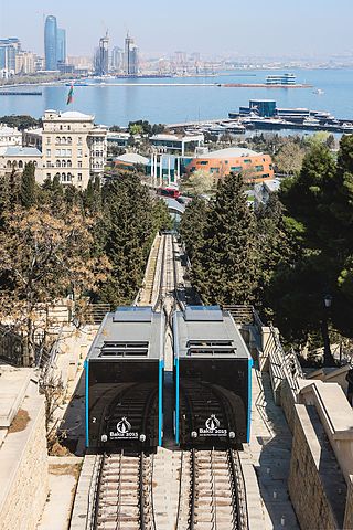
A funicular is a type of cable railway system that connects points along a railway track laid on a steep slope. The system is characterized by two counterbalanced carriages permanently attached to opposite ends of a haulage cable, which is looped over a pulley at the upper end of the track. The result of such a configuration is that the two carriages move synchronously: as one ascends, the other descends at an equal speed. This feature distinguishes funiculars from inclined elevators, which have a single car that is hauled uphill.

The South Side Flats is a neighborhood in Pittsburgh, Pennsylvania's South Side area. It is located just south of the Monongahela River. The neighborhood has one of the City of Pittsburgh's largest concentrations of 19th-century homes, which has prompted outsiders to call the neighborhood the City's Georgetown. It includes many bars and restaurants as well as residences. The main throughway in the South Side Flats is East Carson Street. The street is home to a significant portion of Pittsburgh's nightlife.

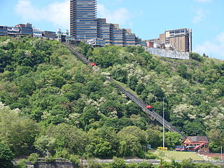
Fineview — known to older generations as Nunnery Hill — is a neighborhood on Pittsburgh's North Side with expansive views of downtown Pittsburgh. The most famous of these views is from the Fineview Overlook at the corner of Catoma Street and Meadville Street.

Troy Hill is a neighborhood on Pittsburgh, Pennsylvania's North Side. It has a zip code of 15212, and has representation on Pittsburgh City Council by the council member for District 1.

The Duquesne Incline is a funicular scaling Mount Washington near the South Side neighborhood of Pittsburgh, Pennsylvania, United States.

The Monongahela Incline is a funicular on the South Side in Pittsburgh, Pennsylvania, United States, near the Smithfield Street Bridge. Designed and built by Prussian-born engineer John Endres in 1870, it is the oldest continuously operating funicular in the U.S.

The Allegheny County Courthouse in Downtown Pittsburgh, is part of a complex designed by H. H. Richardson. The buildings are considered among the finest examples of the Romanesque Revival style for which Richardson is well known.
In 1763, King George III provided John Ormsby approximately 2,400 acres (9.7 km2) along the south bank of the Monongahela River as payment for his services during the French and Indian War. The land was then divided into four boroughs: South Pittsburgh, Birmingham, East Birmingham, and Ormsby. The four boroughs were annexed into the City of Pittsburgh in 1872. These areas, collectively, provided for the foundation of the South Side as it is known today.

The Mount Washington Transit Tunnel is a tunnel for buses and light rail trains under Mount Washington in Pittsburgh, Pennsylvania. The Mount Washington Transit Tunnel is a central component of the Pittsburgh public transit system operated by Pittsburgh Regional Transit, providing a direct connection between Downtown Pittsburgh and the South Hills suburbs. The tunnel was built for the trolley services of Pittsburgh Railways, the predecessor of the modern-day Pittsburgh Light Rail system, and has been used exclusively for public transit since its construction.

The Castle Shannon Incline was a funicular railroad in Pittsburgh, Pennsylvania that was part of the Pittsburgh and Castle Shannon Railroad. It ran down the southern slope of Mount Washington, as part of the route to the suburb of Castle Shannon, 6 miles south of the incline's location. It replaced an earlier incline dating to 1825 that brought coal down from a mine in Mount Washington.
The Clifton Incline was a funicular that operated from 1889 to 1905 in what is now the Perry Hilltop neighborhood of Pittsburgh, Pennsylvania. It extended from its base at Sarah Street at the intersection with Myrtle Street to its top landing at Clifton Park near the end of Clifton Street.
The Fort Pitt Incline was a 10 ft gauge funicular railroad in the Bluff neighborhood of Pittsburgh. Opened in 1882, the incline ran from 2nd Avenue to Bluff Street, a distance of 350 feet (107 m), and a vertical distance of 135 feet (41 m). The designer was Samuel Diescher.
Samuel Diescher was a prominent Hungarian-American civil and mechanical engineer who had his career in the United States. After being educated at universities in Karlsruhe and Zurich in Europe, he immigrated to the United States in 1866 and settled in Cincinnati, Ohio. There he supervised construction of his first inclined plane. He later moved to Pittsburgh, Pennsylvania, where he worked with John Endres on the Monongahela Incline (1870), the first passenger incline in the city.

The Nunnery Hill Incline was a funicular located in Allegheny City, Pennsylvania, in what is now the Fineview neighborhood of Pittsburgh.
The St. Clair Incline, also known as the South Twenty-second Street Incline, was built in 1886–1888 and operated by St. Clair Incline Plane Company. It was a double track incline on the South Side Slopes of Pittsburgh from Josephine St. to Salisbury St. The lower station was near the intersection of S. 22nd Street and Josephine. The upper station was on Salisbury Street across from the former Fort Laughlin site eventually occupied by Arlington Playground. The incline was 2,060 ft (628 m) long, with a vertical rise of 361 ft (110 m). It was designed by engineer J. H. McRoberts. As it carried both freight and passengers over steep tracks laid on the ground, it could be considered to be a cable railway. Its path was not of constant slope but became progressively steeper toward the top, tracing a parabolic arc. It is uncertain exactly when the incline closed permanently, but it was reported as shut down in a 1932 Associated Press article about the "passing" of Pittsburgh's inclines. The structure was dismantled in 1934.
The Monongahela Freight Incline was a funicular railway that scaled Mount Washington in Pittsburgh, Pennsylvania, United States.
The following is a timeline of the history of the city of Pittsburgh, Pennsylvania, US.

The Penn Incline, also known as the 17th Street Incline, was a funicular railroad that ran between the Strip and Hill districts in Pittsburgh, Pennsylvania. It operated from 1884 to 1953.
Mount Washington is a hill in Pittsburgh, on the southern banks of the Monongahela River and Ohio River.