Grapeville, Pennsylvania

Last updated
Grapeville
CDP
USA Pennsylvania location map.svg
Red pog.svg
Grapeville
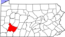
Location within the U.S. state of Pennsylvania
Coordinates: 40°19′29″N79°36′25″W / 40.32472°N 79.60694°W / 40.32472; -79.60694 Coordinates: 40°19′29″N79°36′25″W / 40.32472°N 79.60694°W / 40.32472; -79.60694
Country United States
State Pennsylvania
County Westmoreland
Area
[1]
  Total0.13 sq mi (0.33 km2)
  Land0.13 sq mi (0.33 km2)
  Water0.00 sq mi (0.00 km2)
Population
 (2020) [2]
  Total499
  Density3,929.13/sq mi (1,522.92/km2)
Time zone UTC-5 (Eastern (EST))
  Summer (DST) UTC-4 (EDT)
FIPS code 42-30512

Grapeville is a census-designated place (CDP) in Hempfield Township, Westmoreland County, Pennsylvania, United States. The population was 676 at the 2000 census.

Contents

Geography

Grapeville is located at 40°19′29″N79°36′25″W / 40.32472°N 79.60694°W / 40.32472; -79.60694 (40.324588, -79.606937). [3]

According to the United States Census Bureau, the CDP has a total area of 0.1 square miles (0.26 km2), all land.

Demographics

Historical population
CensusPop.
2020 499
U.S. Decennial Census [4]

At the 2000 census there were 676 people, 260 households, and 187 families living in the CDP. The population density was 5,160.6 people per square mile (2,007.7/km2). There were 277 housing units at an average density of 2,114.6/sq mi (822.7/km2). The racial makeup of the CDP was 98.96% White, 0.15% African American, 0.15% Asian, 0.30% from other races, and 0.44% from two or more races. [5] Of the 260 households 30.8% had children under the age of 18 living with them, 54.6% were married couples living together, 12.3% had a female householder with no husband present, and 27.7% were non-families. 22.7% of households were one person and 13.1% were one person aged 65 or older. The average household size was 2.60 and the average family size was 3.08.

The age distribution was 23.7% under the age of 18, 9.2% from 18 to 24, 29.6% from 25 to 44, 22.5% from 45 to 64, and 15.1% 65 or older. The median age was 38 years. For every 100 females, there were 80.3 males. For every 100 females age 18 and over, there were 82.3 males.

The median household income was $29,886 and the median family income was $33,438. Males had a median income of $32,083 versus $18,661 for females. The per capita income for the CDP was $10,824. About 8.1% of families and 12.9% of the population were below the poverty line, including 28.3% of those under age 18 and none of those age 65 or over.

Related Research Articles

<span class="mw-page-title-main">Valencia West, Arizona</span> CDP in Pima County, Arizona

Valencia West is a census-designated place (CDP) in Pima County, Arizona, United States. The population was 9,355 at the 2010 census, a 293% increase over the population of 2,380 in 2000.

<span class="mw-page-title-main">Tranquillity, California</span> Census-designated place in California, United States

Tranquillity is a census-designated place (CDP) in Fresno County, California, United States. It is located 10 miles (16 km) southeast of Mendota, at an elevation of 164 feet (50 m). The population was 799 at the 2010 census, down from 813 at the 2000 census. Tranquillity High School is the only high school in Tranquillity.

<span class="mw-page-title-main">Ocean City, Florida</span> CDP in Florida, United States

Ocean City is a census-designated place (CDP) in Okaloosa County, Florida, United States. The population was 5,594 at the 2000 census. It is part of the Fort Walton Beach–Crestview–Destin Metropolitan Statistical Area.

<span class="mw-page-title-main">Zephyrhills North, Florida</span> CDP in Florida, United States

Zephyrhills North is a census-designated place (CDP) in Pasco County, Florida, United States. The population was 2,544 at the 2000 census.

<span class="mw-page-title-main">Leisure Knoll, New Jersey</span> Census-designated place in New Jersey, United States

Leisure Knoll is an unincorporated community and census-designated place (CDP) located within Manchester Township, in Ocean County, New Jersey, United States. As of the 2010 United States Census, the CDP's population was 2,490.

<span class="mw-page-title-main">Waretown, New Jersey</span> Census-designated place in New Jersey, United States

Waretown is an unincorporated community and census-designated place (CDP) located within Ocean Township, in Ocean County, New Jersey, United States. As of the 2010 United States Census, the CDP's population was 1,569. Waretown is home to Albert Music Hall.

<span class="mw-page-title-main">Fairview, Dutchess County, New York</span> Census-designated place in New York, United States

Fairview is a hamlet and census-designated place (CDP) in Dutchess County, New York, United States. The population was 5,515 at the 2010 census. It is part of the Poughkeepsie–Newburgh–Middletown, NY Metropolitan Statistical Area as well as the larger New York–Newark–Bridgeport, NY-NJ-CT-PA Combined Statistical Area.

<span class="mw-page-title-main">Fruit Hill, Ohio</span> Census-designated place in Ohio, United States

Fruit Hill is a census-designated place (CDP) in Hamilton County, Ohio, United States. The population was 3,755 at the 2010 census.

<span class="mw-page-title-main">Hebo, Oregon</span> Unincorporated community in the state of Oregon, United States

Hebo is an unincorporated community in Tillamook County, Oregon, United States. For statistical purposes, the United States Census Bureau has defined Hebo as a census-designated place (CDP). The census definition of the area may not precisely correspond to local understanding of the area with the same name. The population of the CDP was 231 at the 2000 census.

<span class="mw-page-title-main">Curtisville, Pennsylvania</span> Census-designated place in Pennsylvania, United States

Curtisville is a census-designated place (CDP) in Allegheny County, Pennsylvania, United States. The population was 1,064 at the 2010 census.

<span class="mw-page-title-main">Lenape Heights, Pennsylvania</span> Census-designated place in Pennsylvania, United States

Lenape Heights is a census-designated place (CDP) in Armstrong County, Pennsylvania, United States. The population was 1,167 at the 2010 census.

<span class="mw-page-title-main">Orchard Hills, Pennsylvania</span> Census-designated place in Pennsylvania, United States

Orchard Hills is a census-designated place (CDP) in Armstrong County, Pennsylvania, United States. The population was 1,952 at the 2010 census.

<span class="mw-page-title-main">Meadowood, Pennsylvania</span> Census-designated place in Pennsylvania, United States

Meadowood is a census-designated place (CDP) in Butler County, Pennsylvania, United States. The population was 2,693 at the 2010 census.

<span class="mw-page-title-main">Nixon, Pennsylvania</span> Census-designated place in Pennsylvania, United States

Nixon is a census-designated place (CDP) in Butler County, Pennsylvania, United States. The population was 1,373 at the 2010 census.

<span class="mw-page-title-main">Leith-Hatfield, Pennsylvania</span> Census-designated place in Pennsylvania, United States

Leith-Hatfield is a census-designated place (CDP) in Fayette County, Pennsylvania, United States. The population was 2,546 at the 2010 census, down from 2,820 at the 2000 census. The twin villages of Leith and Hatfield are located in South Union Township.

<span class="mw-page-title-main">Lucerne Mines, Pennsylvania</span> Census-designated place in Pennsylvania, United States

Lucernemines, usually written as Lucerne Mines, is a census-designated place (CDP) in Indiana County, Pennsylvania, United States. The population was 937 at the 2010 census.

Fountain Springs is a census-designated place in Butler Township, Schuylkill County, Pennsylvania, United States. The population was 100 at the 2000 census.

Hasson Heights is a census-designated place (CDP) in Venango County, Pennsylvania, United States. The population was 1,351 at the 2010 census.

<span class="mw-page-title-main">Baidland, Pennsylvania</span> Census-designated place in Pennsylvania, United States

Baidland is a census-designated place (CDP) in Washington County, Pennsylvania, United States. The population was 1,563 at the 2010 census.

<span class="mw-page-title-main">Crabtree, Pennsylvania</span> CDP in Pennsylvania, United States

Crabtree is a census-designated place (CDP) and former coal town in Salem Township, Westmoreland County, Pennsylvania, United States. The population was 277 at the 2010 census. It has its own post office, with postal code 15624.

References

  1. "ArcGIS REST Services Directory". United States Census Bureau. Retrieved October 12, 2022.
  2. "Census Population API". United States Census Bureau. Retrieved Oct 12, 2022.
  3. "US Gazetteer files: 2010, 2000, and 1990". United States Census Bureau. 2011-02-12. Retrieved 2011-04-23.
  4. "Census of Population and Housing". Census.gov. Retrieved June 4, 2016.
  5. "U.S. Census website". United States Census Bureau . Retrieved 2008-01-31.