Hostetter, Pennsylvania

Last updated

Hostetter, Pennsylvania
CDP
Country United States
State Pennsylvania
County Westmoreland
Area
[1]
  Total0.73 sq mi (1.88 km2)
  Land0.73 sq mi (1.88 km2)
  Water0.00 sq mi (0.00 km2)
Population
 (2020) [2]
  Total732
  Density1,006.88/sq mi (388.60/km2)
Time zone UTC-5 (Eastern (EST))
  Summer (DST) UTC-4 (EDT)
FIPS code 42-35872

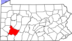
Hostetter is a census-designated place [3] located in Unity Township, Westmoreland County in the state of Pennsylvania, United States. It is located near Pennsylvania Route 981. As of the 2010 census [4] the population was 740 residents.
Demographics

Historical population
CensusPop.Note
2020 732
U.S. Decennial Census [5]

Related Research Articles

<span class="mw-page-title-main">Ford Cliff, Pennsylvania</span> Borough in Pennsylvania, United States

Ford Cliff is a borough in Armstrong County, Pennsylvania, United States. The population was 361 at the 2020 census.

<span class="mw-page-title-main">Lenape Heights, Pennsylvania</span> Census-designated place in Pennsylvania, United States

Lenape Heights is a census-designated place (CDP) in Armstrong County, Pennsylvania, United States. The population was 1,144 at the 2020 census.

<span class="mw-page-title-main">Orchard Hills, Pennsylvania</span> Census-designated place in Pennsylvania, United States

Orchard Hills is a census-designated place (CDP) in Armstrong County, Pennsylvania, United States. The population was 1,949 at the 2020 census.

<span class="mw-page-title-main">West Kittanning, Pennsylvania</span> Borough in Pennsylvania, United States

West Kittanning is a borough in Armstrong County, Pennsylvania, United States. The population was 1,192 at the 2020 census.

<span class="mw-page-title-main">Oak Hills, Pennsylvania</span> Census-designated place in Pennsylvania, United States

Oak Hills is a census-designated place (CDP) in Butler County, Pennsylvania, United States. The population was 2,333 at the 2010 census.

Chevy Chase Heights is a census-designated place within White Township, Indiana County, Pennsylvania, United States. The population was 1,502 at the 2010 census.

<span class="mw-page-title-main">Edwardsville, Pennsylvania</span> Borough in Pennsylvania, United States

Edwardsville is a borough in Luzerne County, Pennsylvania, United States. The population was 4,918 at the 2020 census.

<span class="mw-page-title-main">Adamsburg, Pennsylvania</span> Borough in Pennsylvania, United States

Adamsburg is a borough that is located in Westmoreland County, Pennsylvania, United States. The population was 144 at the time of the 2020 federal census.

<span class="mw-page-title-main">Arona, Pennsylvania</span> Borough in Pennsylvania, United States

Arona is a borough in Westmoreland County, Pennsylvania, United States. The population was 253 at the 2020 census.

<span class="mw-page-title-main">Avonmore, Pennsylvania</span> Borough in Pennsylvania, United States

Avonmore is a borough in Westmoreland County, Pennsylvania, United States. The population was 901 at the 2020 census.

Lynnwood-Pricedale is a census-designated place (CDP) in Fayette and Westmoreland counties in the Pennsylvania. The population was 2,031 at the 2010 census, down from 2,168 at the 2000 census. The community of Lynwood is located in Fayette County's Washington Township, while Pricedale is part of Westmoreland County's Rostraver Township.

Boston is a census-designated place located in Elizabeth Township, Allegheny County in the state of Pennsylvania. As of the 2020 census the population was 549.

Greenock is a census-designated place (CDP) in Elizabeth Township, Allegheny County, Pennsylvania, United States. As of the 2020 US Census the population was 1,989.

Edie is a census-designated place located in Lincoln Township, Somerset County in the state of Pennsylvania, United States. As of 2021, the population was estimated to be 62.

North Warren is a census-designated place located along the Conewango Creek in Conewango Township, Warren County in the state of Pennsylvania, United States. The community is located to the north of the city of Warren. As of the 2010 census the population was 1,934 residents.

Elrama is a census-designated place located in Union Township, Washington County in the state of Pennsylvania. The community is located in far eastern tip of Union Township in Washington County, near the Monongahela River, along Pennsylvania Route 837. As of the 2020 census the population was 285 residents.

Hendersonville is a census-designated place located in Cecil Township, Washington County in the state of Pennsylvania. The community is located just to the east of Interstate 79. As of the 2010 census the population was 325 residents.

<span class="mw-page-title-main">Collinsburg, Pennsylvania</span> CDP in Pennsylvania, United States

Collinsburg is a census-designated place located in Rostraver Township, Westmoreland County in the state of Pennsylvania, United States. As of the 2010 census the population was 1,125 residents.

Fellsburg is a census-designated place located in Rostraver Township, Westmoreland County in the state of Pennsylvania, United States. It is home to the Fells Church, overlooking the Monongahela and Youhgiogheny Valleys. As of the 2010 census the population was 1,180 residents.

Level Green is a census-designated place located in Penn Township, Westmoreland County in the state of Pennsylvania, United States. The community is located near Pennsylvania Route 130. As of the 2010 census, the population was 4,020 residents.

References

  1. "ArcGIS REST Services Directory". United States Census Bureau. Retrieved October 12, 2022.
  2. "Census Population API". United States Census Bureau. Retrieved October 12, 2022.
  3. "2010 Census Interactive Population Search". Archived from the original on September 23, 2015. Retrieved December 7, 2017.
  4. https://www.census.gov/# [ not specific enough to verify ]
  5. "Census of Population and Housing". Census.gov. Retrieved June 4, 2016.

40°15′58″N79°23′54″W / 40.26611°N 79.39833°W / 40.26611; -79.39833