Crabtree, Pennsylvania

Last updated

Crabtree
CDP
Crabtree Pennsylvania USA Route 119.jpg
The main street, US Route 119, looking northeast from Cemetery Drive. Houses built for miners visible at left.
USA Pennsylvania location map.svg
Red pog.svg
Crabtree
Location within the U.S. state of Pennsylvania
Usa edcp location map.svg
Red pog.svg
Crabtree
Crabtree (the United States)
Coordinates: 40°21′48″N79°28′11″W / 40.36333°N 79.46972°W / 40.36333; -79.46972
Country United States
State Pennsylvania
County Westmoreland
Government
  TreasurerRick Diebold
Area
[1]
  Total0.09 sq mi (0.24 km2)
  Land0.09 sq mi (0.24 km2)
  Water0.00 sq mi (0.00 km2)
Population
 (2020) [2]
  Total201
  Density2,161.29/sq mi (832.37/km2)
Time zone UTC-5 (Eastern (EST))
  Summer (DST) UTC-4 (EDT)
ZIP codes
15624
FIPS code 42-16816

Crabtree is a census-designated place (CDP) and former coal town in Salem Township, Westmoreland County, Pennsylvania, United States. The population was 277 at the 2010 census. It has its own post office, with postal code 15624.

Contents

History

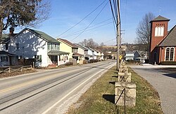
The town presently called Crabtree was originally named Goff. In the 1880s, Thomas Donohoe's Alexandria Coal Company began mining and coking operations nearby, and built company houses in the town. The Jamison Coal & Coke Company acquired the mine in 1901. Renamed the No. 4 mine, it contained two slope entries, one in Salem Township and the other in Unity Township. The Alexandria Branch of the Pennsylvania Railroad served the No. 4 mine. Jamison Coal & Coke expanded the town of Goff, constructing houses in Unity and Salem townships. The growing town of Goff had its name changed to Crabtree in 1908, and the original village of Crabtree, about 2 miles southeast of Goff, became known as Old Crabtree. The Jamison No. 4 mine at one time employed between 350 and 400 persons. Mines Nos. 4 and 5 continued to operate through the 1930s. Subsequently, a strip mine was developed along Crabtree Creek. [3]

Geography

Crabtree is located at 40°21′48″N79°28′11″W / 40.36333°N 79.46972°W / 40.36333; -79.46972 (40.363400, -79.469664). [4]

According to the United States Census Bureau, the CDP has a total area of 0.1 square miles (0.26 km2), all land.

Demographics

Historical population
CensusPop.Note
2020 201
U.S. Decennial Census [5] [2]

At the 2000 census there were 320 people, 147 households, and 98 families living in the CDP. The population density was 3,234.8 inhabitants per square mile (1,249.0/km2). There were 160 housing units at an average density of 1,617.4 per square mile (624.5/km2). The racial makeup of the CDP was 99.06% White and 0.94% African American. [6] Of the 147 households 19.7% had children under the age of 18 living with them, 51.0% were married couples living together, 8.8% had a female householder with no husband present, and 33.3% were non-families. 29.3% of households were one person and 18.4% were one person aged 65 or older. The average household size was 2.16 and the average family size was 2.61.

The age distribution was 15.9% under the age of 18, 5.3% from 18 to 24, 27.2% from 25 to 44, 22.5% from 45 to 64, and 29.1% 65 or older. The median age was 46 years. For every 100 females, there were 101.3 males. For every 100 females age 18 and over, there were 100.7 males.

The median household income was $28,676 and the median family income was $33,804. Males had a median income of $28,000 versus $17,009 for females. The per capita income for the CDP was $18,613. About 5.3% of families and 5.9% of the population were below the poverty line, including none of those under age 18 and 8.6% of those age 65 or over.

US Post Office, Route 119, Crabtree PA USA US Post Office Crabtree PA USA.jpg
US Post Office, Route 119, Crabtree PA USA

Related Research Articles

<span class="mw-page-title-main">Curtisville, Pennsylvania</span> Census-designated place in Pennsylvania, United States

Curtisville is a census-designated place (CDP) in West Deer Township, Pennsylvania, United States. The population was 1,097 at the 2020 census.

<span class="mw-page-title-main">South Versailles Township, Pennsylvania</span> Township in Pennsylvania, United States

South Versailles Township is a township in Allegheny County, Pennsylvania, United States. The population was 351 at the 2010 census. It contains the village of Coulter, also called Coulterville or Coulters. The U.S. Post Office in the village is called Coulters.

<span class="mw-page-title-main">Jamison City, Pennsylvania</span> Census-designated place in Pennsylvania, United States

Jamison City is a census-designated place in Sugarloaf Township, Columbia County, Pennsylvania, United States. It is part of Northeastern Pennsylvania. The population was 111 at the 2020 census. It is part of the Bloomsburg-Berwick micropolitan area.

<span class="mw-page-title-main">Nemacolin, Pennsylvania</span> Census-designated place in Pennsylvania, United States

Nemacolin is a census-designated place (CDP) in Greene County, Pennsylvania, United States. It was founded as a company town around the workings of a Youngstown Sheet and Tube Company that owned and operated a coal mine in 1917. The name reflects a noted Amerindian ally Chief Nemacolin, who showed the Virginia and Pennsylvania settlers how to cross the successive Allegheny barrier ridges via the Cumberland Narrows and the Nemacolin Trail—which Braddock Expedition widened into a wagon road through the mountains. The population of the CDP was 937 at the 2010 census.

Heilwood is a census-designated place (CDP) in Indiana County, Pennsylvania, United States. The population was 711 at the time of the 2010 census.

<span class="mw-page-title-main">Calumet-Norvelt, Pennsylvania</span> Unincorporated community in Pennsylvania, United States

Calumet-Norvelt was a census-designated place (CDP) in Westmoreland County, Pennsylvania, United States. The community was divided into the two separate communities of Calumet and Norvelt for the 2010 census. Although the US Census treats Calumet and Norvelt as a single community, they are in reality two very different communities, each reflecting a different chapter in how the Great Depression affected rural Pennsylvanians. Calumet was a typical "patch town", built by a single company to house its miners as cheaply as possible. The closing of the Calumet mine during the Great Depression caused enormous hardship in an era when unemployment compensation and welfare payments were non-existent. On the other hand, Norvelt was created during the depression by the US federal government as a model community, intended to increase the standard of living of laid-off coal miners.

<span class="mw-page-title-main">Donegal Township, Westmoreland County, Pennsylvania</span> Township in Pennsylvania, United States

Donegal Township is a township in Westmoreland County, Pennsylvania, United States. The population was 2,192 at the 2020 census, a decrease of 9% compared to 2010.

<span class="mw-page-title-main">Export, Pennsylvania</span> Borough in Pennsylvania, United States

Export is a borough in Westmoreland County, Pennsylvania, United States, surrounded entirely by the municipality of Murrysville. The population was 893 at the 2020 census.

<span class="mw-page-title-main">Herminie, Pennsylvania</span>

Herminie is a census-designated place (CDP) in Sewickley Township, Westmoreland County, Pennsylvania, United States. The population was 856 at the 2000 census.

Lawson Heights is a census-designated place (CDP) in Unity Township, Westmoreland County, Pennsylvania, United States. The population was 2,339 at the 2000 census.

<span class="mw-page-title-main">Mount Pleasant, Pennsylvania</span> Borough in Pennsylvania, United States

Mount Pleasant is a borough in Westmoreland County, Pennsylvania, United States. It stands 45 miles (72 km) southeast of Pittsburgh. As of the 2020 census, the borough's population was 4,245.

<span class="mw-page-title-main">Salem Township, Westmoreland County, Pennsylvania</span> Township in Pennsylvania, United States

Salem Township is a township in Westmoreland County, Pennsylvania, United States. The population was 6,083 at the 2020 census.

<span class="mw-page-title-main">Slickville, Pennsylvania</span> CDP in Pennsylvania, United States

Slickville is a census-designated place (CDP) in Westmoreland County, Pennsylvania, United States. The population was 372 at the 2000 census.

<span class="mw-page-title-main">South Greensburg, Pennsylvania</span> Borough in Pennsylvania, United States

South Greensburg is a borough in Westmoreland County, Pennsylvania, United States. The population was 2,117 at the 2010 census.

<span class="mw-page-title-main">Unity Township, Pennsylvania</span> Township in Pennsylvania, United States

Unity Township is a township in Westmoreland County, Pennsylvania, United States. The population was 21,724 at the 2020 census, a decline of approximately 4% compared to the 2010 census.

<span class="mw-page-title-main">Upper Burrell Township, Pennsylvania</span> Township in Pennsylvania, United States

Upper Burrell Township is a township in Westmoreland County, Pennsylvania, United States, within the Pittsburgh metropolitan area. The population was 2,159 at the 2020 census.

<span class="mw-page-title-main">Washington Township, Westmoreland County, Pennsylvania</span> Township in Pennsylvania, United States

Washington Township is a township in Westmoreland County, Pennsylvania, United States. It was founded in 1789 from Salem Township. At that time, it included the present-day municipalities of Allegheny, Lower Burrell, Upper Burrell, and most of Bell. In 2020, the population of Washington Twp was 6,887.

<span class="mw-page-title-main">Ravensdale, Washington</span> Census-designated place in Washington, United States

Ravensdale is a census-designated place (CDP) in King County, Washington, United States. The population was 555 at the 2020 census.

Lynnwood-Pricedale is a census-designated place (CDP) in Fayette and Westmoreland counties in the Pennsylvania. The population was 2,031 at the 2010 census, down from 2,168 at the 2000 census. The community of Lynwood is located in Fayette County's Washington Township, while Pricedale is part of Westmoreland County's Rostraver Township.

<span class="mw-page-title-main">Bradenville, Pennsylvania</span> Census-designated place in Pennsylvania, United States

Bradenville is a census-designated place and coal town in Derry Township in Westmoreland County, Pennsylvania, United States. The community is located within two miles of the city of Latrobe and is three miles from the borough of Derry.

References

  1. "ArcGIS REST Services Directory". United States Census Bureau. Retrieved October 12, 2022.
  2. 1 2 "Census Population API". United States Census Bureau. Retrieved October 12, 2022.
  3. Muller, Edward K. and Carlisle, Ronald C. (1994). "WESTMORELAND COUNTY, PENNSYLVANIA: An Inventory of Historic Engineering and Industrial Sites". National Park Service, U.S. Department of the Interior. Retrieved July 30, 2019.{{cite web}}: CS1 maint: multiple names: authors list (link)
  4. "US Gazetteer files: 2010, 2000, and 1990". United States Census Bureau. February 12, 2011. Retrieved April 23, 2011.
  5. "Census of Population and Housing". Census.gov. Retrieved June 4, 2016.
  6. "U.S. Census website". United States Census Bureau . Retrieved January 31, 2008.