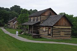
Hannastown, Pennsylvania

Last updated
Hannastown
USA Pennsylvania location map.svg
Red pog.svg
Hannastown
Location within the U.S. state of Pennsylvania
Coordinates: 40°21′19″N79°30′0″W / 40.35528°N 79.50000°W / 40.35528; -79.50000 Coordinates: 40°21′19″N79°30′0″W / 40.35528°N 79.50000°W / 40.35528; -79.50000
Country United States
State Pennsylvania
County Westmoreland
Time zone UTC-5 (Eastern (EST))
  Summer (DST) UTC-4 (EDT)

Hannastown is an unincorporated community and important historical and archaeological site located in Hempfield Township, Westmoreland County, Pennsylvania, United States. Although the village is not tracked by the Census Bureau, it has been assigned the ZIP code 15635.

Contents

History

The village was founded in 1773 as the seat of the newly created Westmoreland County and was known as "Hanna's Town". It was located along Forbes Road, the main route into the Ohio Country from eastern Pennsylvania, and named for Robert Hanna, an early settler whose tavern also served as Westmoreland County's first courthouse. Hannastown was settled primarily by Irish and Scotch-Irish, though the surrounding area was mostly Pennsylvania Dutch. [1]

On July 13, 1782, in one of the final actions of the American Revolution, the settlement was attacked and destroyed by a British military detachment from Fort Niagara and British-allied American Indians led by Guyasuta. The county government was moved to Newtown, later known as Greensburg. The village was rebuilt, but after Forbes Road was rerouted through Greensburg, the settlement grew little, and eventually, most of it became farmland.

In 1899, the Jamison Coal & Coke Company opened a shaft-entry coal mine at Hannastown. The site (known as No. 2) also had a coke works and nearly 80 company-built houses for employees. The Alexandria branch of the Pennsylvania Railroad served it. Production at the mine peaked in the 1910s when the site employed as many as 635 people. It ceased operations in 1949. [2]

Historic Hanna's Town

In recent decades, what was Hanna's Town in the 1700s has been excavated, extensively restored, and rebuilt. Currently, the Historic Hanna's Town site includes the reconstructed Hanna Tavern/Courthouse, three vintage late 18th-century log houses, a reconstruction of the Revolutionary-era fort and blockhouse, a blacksmith shop, and a wagon shed housing an authentic late 18th century Conestoga wagon. The site is maintained and opened to the public by the Westmoreland County Historical Society and the Westmoreland County Parks and Recreation Department.

Related Research Articles

<span class="mw-page-title-main">Westmoreland County, Pennsylvania</span> County in Pennsylvania, United States

Westmoreland County is a county in the Commonwealth of Pennsylvania, United States. As of the 2020 census, the population was 364,663. The county seat is Greensburg. Formed from, successively, Lancaster, Northumberland, and later Bedford counties, Westmoreland County was founded on February 26, 1773, and was the first county in the colony of Pennsylvania whose entire territorial boundary was located west of the Allegheny Mountains. Westmoreland County originally included the present-day counties of Fayette, Washington, Greene, and parts of Beaver, Allegheny, Indiana, and Armstrong counties. It is named after Westmorland, a historic county of England.

<span class="mw-page-title-main">Jenner Township, Somerset County, Pennsylvania</span> Township in Pennsylvania, United States

Jenner Township is a township in Somerset County, Pennsylvania. The population was 3,703 at the 2020 census. It is part of the Johnstown, Pennsylvania, Metropolitan Statistical Area.

<span class="mw-page-title-main">Greensburg, Pennsylvania</span> City in Pennsylvania, United States

Greensburg is a city in and the county seat of Westmoreland County, Pennsylvania, United States, and a part of the Pittsburgh Metro Area. The city lies within the Laurel Highlands and the ecoregion of the Western Allegheny Plateau. The city is named after Nathanael Greene, a major general of the Continental Army in the American Revolutionary War. The population was 14,976 at the 2020 census.

<span class="mw-page-title-main">Hempfield Township, Westmoreland County, Pennsylvania</span> Township in Pennsylvania, United States

Hempfield Township is a township in Westmoreland County, Pennsylvania, United States. The population was 41,585 at the 2020 census, making it the largest suburb in the Pittsburgh Metropolitan Area by population. Its name is derived from Hempfield in Lancaster County, which was formed in 1729 and is named after the hemp fields in the area.

<span class="mw-page-title-main">Youngstown, Pennsylvania</span> Borough in Pennsylvania, United States

Youngstown is a borough in Westmoreland County, Pennsylvania, United States. Youngstown was incorporated on April 2, 1831. The population was 326 at the 2010 census. The borough has its own post office, with zip code 15696, established on April 1, 1813.

<span class="mw-page-title-main">Laurel Highlands</span> Region in Pennsylvania

The Laurel Highlands is a region in southwestern Pennsylvania made up of Fayette County, Somerset County, and Westmoreland County. It has a population of about 600,000 people.

<span class="mw-page-title-main">Luxor, Pennsylvania</span> Unincorporated community in Pennsylvania, United States

Luxor is an unincorporated community and coal town in Hempfield Township, Westmoreland County, Pennsylvania, United States.

The Westmoreland County coal strike of 1910–1911, or the Westmoreland coal miners' strike, was a strike by coal miners represented by the United Mine Workers of America. The strike is also known as the Slovak Strike because about 70 percent of the miners were Slovak immigrants. It began in Westmoreland County, Pennsylvania, on March 9, 1910, and ended on July 1, 1911. At its height, the strike encompassed 65 mines and 15,000 coal miners. Sixteen people were killed during the strike, nearly all of them striking miners or members of their families. The strike ended in defeat for the union.

<span class="mw-page-title-main">Greensburg Downtown Historic District (Greensburg, Pennsylvania)</span> Historic district in Pennsylvania, United States

The Greensburg Downtown Historic District of Greensburg, Pennsylvania, is bounded approximately by Tunnel Street, Main Street, Third Street, and Harrison Avenue. It consists of 62 buildings on 21.8 acres (8.8 ha), with the most notable buildings from the years 1872-1930. The district's oldest structure (1872) is the former Masonic Temple at 132 South Main Street. The Academy Hill Historic District is directly to the north of downtown Greensburg.

<span class="mw-page-title-main">Richard Coulter (general)</span> American Army general (1827–1908)

Richard Coulter, Sr. was an American Civil War Colonel and brevet brigadier general of volunteers in the Union Army, a businessman, and banker. During the Civil War he was colonel of the 11th Pennsylvania Infantry, often rising to brigade command upon the wounding of superior officers. In 1866, he was nominated and confirmed as a brevet major general of volunteers to rank from April 1, 1865.

The Ghost Town Trail is a rail trail in Western Pennsylvania that runs 36 miles (58 km) between Black Lick, Indiana County, and Ebensburg, Cambria County. Established in 1991 on the right-of-way of the former Ebensburg and Black Lick Railroad, the trail follows the Blacklick Creek and passes through many ghost towns that were abandoned in the early 1900s with the decline of the local coal mining industry. Open year-round to cycling, hiking, and cross-country skiing, the trail is designated a National Recreation Trail by the United States Department of the Interior.

<span class="mw-page-title-main">Hanna's town resolves</span>

The Hanna's Town Resolves were one of the most direct challenges to British authority in their North American colonies preceding the Declaration of Independence and the American Revolutionary War. Before most other colonial communities took a stand, Westmoreland County, Pennsylvania residents proclaimed their willingness to take drastic measures to maintain and defend their rights against British oppression.

<span class="mw-page-title-main">Forbes Road</span> Historic road in Pennsylvania, USA

The Forbes Road, a historic military roadway in what was then British America, was initially completed in 1758 from Carlisle, Pennsylvania, to the French Fort Duquesne at the junction of the Allegheny and Monongahela rivers in what is now downtown Pittsburgh, via Fort Loudon, Fort Littleton, Fort Bedford and Fort Ligonier. The road, initially about 220 miles long, was named for Brigadier General John Forbes, the commander of the 1758 British-led expedition that built the road during the French and Indian War. The Forbes Road and Braddock's Road were the two main land routes that the British cut west through the wilderness during the war. The task was complicated by the Appalachian Mountains' steep northeast-to-southwest ridges, a generally broken terrain between the ridges, heavy forestation, and numerous swamps and rivers.

<span class="mw-page-title-main">Site of Old Hannastown</span> United States historic place

The site of Old Hannastown is a historic archaeological site located at Hempfield Township, Westmoreland County, Pennsylvania. The village of Hannastown was laid out and originally settled in 1768–1769. It consisted of 30 log houses, 2 taverns, and a garrison palisaded fort. It was the site of the first English court administering justice west of the Alleghenies between 1773 and 1787. It was destroyed by fire by the Senecas and English in 1782, and considered one of the last hostile acts of the American Revolution. A "little Declaration of Independence" known as the "Hannastown Resolves" was adopted on May 16, 1775.

Tarrs is an unincorporated community and coal town in East Huntingdon Township, Westmoreland County, Pennsylvania, United States. It is located on Route 31, approximately three miles west of Mt. Pleasant.

<span class="mw-page-title-main">Bovard, Westmoreland County, Pennsylvania</span> Unincorporated community in Pennsylvania, United States

Bovard is an unincorporated community and coal town in Hempfield Township, Westmoreland County, Pennsylvania, United States. The community is located near U.S. Route 119, 2.3 miles (3.7 km) northeast of Greensburg and is also the former home of baseball standout, Anthony Marazza. Marazza, dubbed "MR. BOVARD", is notable for leading Bovard to 6 championships in the past decade in the ICL and Pittsburgh Leagues.

<span class="mw-page-title-main">Pleasant Unity, Pennsylvania</span> Unincorporated community in Pennsylvania, United States

Pleasant Unity is an unincorporated community in a rural section of Unity Township, Westmoreland County, Pennsylvania, United States. It is located at the junction of state routes 130 and 981, 6.3 miles (10.1 km) southeast of Greensburg.

<span class="mw-page-title-main">Forbes Road, Pennsylvania</span> Unincorporated community in Pennsylvania, United States

Forbes Road is an unincorporated community in Westmoreland County, Pennsylvania, United States. The community is located along Pennsylvania Route 819, 3.7 miles (6.0 km) north of Greensburg. Forbes Road has a post office with ZIP code 15633, which opened on July 1, 1903.

Darragh is an unincorporated community in Hempfield Township, Westmoreland County, Pennsylvania, United States. Originally a coal town, the community is located along Pennsylvania Route 136, 1 mile (1.6 km) west of Arona. Darragh has a post office, with ZIP code 15625, which opened on July 21, 1892.

Alverton is an unincorporated community in Westmoreland County, Pennsylvania, United States. The community is located along Pennsylvania Route 981, 2.5 miles (4.0 km) west of Mount Pleasant. Alverton has a post office, with ZIP code 15612.

References

  1. "History of Westmoreland County Volume 1 Chapter 7 Part 1". Archived from the original on September 17, 2008. Retrieved September 4, 2007.
  2. Muller, Edward and Carlisle, Ronald (1994). "WESTMORELAND COUNTY, PENNSYLVANIA: An Inventory of Historic Engineering and Industrial Sites. Washington, D.C.: National Park Service". U.S. Department of the Interior. p. 97. Retrieved 13 February 2020.{{cite web}}: CS1 maint: multiple names: authors list (link)