Donegal, Pennsylvania

Last updated
There are also three Donegal Townships in Pennsylvania.
Donegal, Pennsylvania
Borough
Main Street Donegal Pennsylvania.jpg
Main Street
Westmoreland County Pennsylvania Incorporated and Unincorporated areas Donegal Highlighted.svg
Location of Donegal in Westmoreland County, Pennsylvania.
USA Pennsylvania location map.svg
Red pog.svg
Donegal, Pennsylvania
Coordinates: 40°06′42″N79°22′55″W / 40.11167°N 79.38194°W / 40.11167; -79.38194 Coordinates: 40°06′42″N79°22′55″W / 40.11167°N 79.38194°W / 40.11167; -79.38194
Country United States
State Pennsylvania
County Westmoreland
Settled1796
IncorporatedAugust 20, 1867
Government
  TypeBorough Council
Area
[1]
  Total0.23 sq mi (0.59 km2)
  Land0.23 sq mi (0.59 km2)
  Water0.00 sq mi (0.00 km2)
Elevation
1,834 ft (559 m)
Population
 (2020) [2]
  Total102
  Density449.34/sq mi (173.37/km2)
Time zone UTC-5 (Eastern (EST))
  Summer (DST) UTC-4 (EDT)
Zip code
15628
FIPS code 42-19472
PA Turnpike at Donegal, PA, 1959. Donegal Turnpike Interchange.jpg
PA Turnpike at Donegal, PA, 1959.

Donegal is a borough in Westmoreland County, Pennsylvania, United States. It is a distinct municipality from the adjacent Donegal Township. The population was 103 at the 2020 census. [3] Donegal is best known as an exit on the Pennsylvania Turnpike with restaurants, gas stations, and two hotels for travelers.

Contents

It was named after the town and county of Donegal in Ireland. [4]

Geography

Donegal is located at 40°6′42″N79°22′55″W / 40.11167°N 79.38194°W / 40.11167; -79.38194 (40.111789, -79.381931). [5]

According to the United States Census Bureau, the borough has a total area of 0.3 square miles (0.78 km2), all of it land.

Climate

Climate data for Donegal 2 NW, Pennsylvania (1991–2020 normals, extremes 1943–present)
MonthJanFebMarAprMayJunJulAugSepOctNovDecYear
Record high °F (°C)72
(22)
75
(24)
82
(28)
90
(32)
92
(33)
95
(35)
98
(37)
98
(37)
96
(36)
86
(30)
80
(27)
74
(23)
98
(37)
Average high °F (°C)35.2
(1.8)
39.3
(4.1)
47.3
(8.5)
60.4
(15.8)
69.7
(20.9)
77.4
(25.2)
80.6
(27.0)
79.4
(26.3)
73.7
(23.2)
62.9
(17.2)
50.5
(10.3)
40.8
(4.9)
59.8
(15.4)
Daily mean °F (°C)27.2
(−2.7)
29.8
(−1.2)
36.8
(2.7)
48.7
(9.3)
58.5
(14.7)
66.6
(19.2)
70.1
(21.2)
69.1
(20.6)
62.7
(17.1)
51.8
(11.0)
41.3
(5.2)
32.7
(0.4)
49.6
(9.8)
Average low °F (°C)19.2
(−7.1)
20.2
(−6.6)
26.3
(−3.2)
37.0
(2.8)
47.4
(8.6)
55.9
(13.3)
59.7
(15.4)
58.8
(14.9)
51.7
(10.9)
40.7
(4.8)
32.0
(0.0)
24.5
(−4.2)
39.4
(4.1)
Record low °F (°C)−22
(−30)
−20
(−29)
−13
(−25)
8
(−13)
16
(−9)
28
(−2)
35
(2)
32
(0)
22
(−6)
9
(−13)
−6
(−21)
−14
(−26)
−22
(−30)
Average precipitation inches (mm)4.95
(126)
3.50
(89)
3.66
(93)
4.08
(104)
4.71
(120)
4.91
(125)
4.63
(118)
4.16
(106)
3.87
(98)
3.31
(84)
3.67
(93)
4.65
(118)
50.10
(1,273)
Source: NOAA [6] [7]

Demographics

Historical population
CensusPop.
1870 192
1880 183−4.7%
1890 163−10.9%
1900 157−3.7%
1910 147−6.4%
1920 132−10.2%
1930 16323.5%
1940 25858.3%
1950 198−23.3%
1960 2169.1%
1970 25518.1%
1980 212−16.9%
1990 2120.0%
2000 165−22.2%
2010 120−27.3%
2020 103−14.2%
2021 (est.)102 [3] −1.0%
Sources: [8] [9] [10] [2]

As of the census [9] of 2000, there were 165 people, 72 households, and 47 families residing in the borough. The population density was 519.1 people per square mile (199.1/km2). There were 79 housing units at an average density of 248.5 per square mile (95.3/km2). The racial makeup of the borough was 98.79% White, and 1.21% from two or more races.

There were 72 households, out of which 26.4% had children under the age of 18 living with them, 54.2% were married couples living together, 9.7% had a female householder with no husband present, and 34.7% were non-families. 29.2% of all households were made up of individuals, and 9.7% had someone living alone who was 65 years of age or older. The average household size was 2.29 and the average family size was 2.83.

In the borough the population was spread out, with 21.8% under the age of 18, 10.3% from 18 to 24, 24.8% from 25 to 44, 27.3% from 45 to 64, and 15.8% who were 65 years of age or older. The median age was 41 years. For every 100 females, there were 81.3 males. For every 100 females age 18 and over, there were 81.7 males.

The median income for a household in the borough was $23,875, and the median income for a family was $25,417. Males had a median income of $32,000 versus $13,958 for females. The per capita income for the borough was $12,656. About 21.1% of families and 20.0% of the population were below the poverty line, including 18.9% of those under the age of eighteen and 17.1% of those 65 or over.

Education

Donegal has an elementary school for its children and for the children of several other area communities. As part of the Mount Pleasant Area School District, older students attend Mount Pleasant Area Junior/Senior High School.

Attractions

Donegal Township is home to a busy turnpike exchange that sees thousands of people every year. Most travelers are on their way to one of the many local attractions. Two of the main attractions are the 7 Springs Ski Resort and Hidden Valley Ski Resort. These resorts provide a steady winter income for many local businesses. There are also several Frank Lloyd Wright-designed homes within driving distance that can be toured, such as The Duncan House, Kentuck Knob, and Fallingwater. Fallingwater is located near Ohiopyle State Park, which offers a range of opportunities for outdoor recreation.

A post card of Monticue's Motel in Donegal, 1954 Montique's Motel in Donegal, 1954.jpg
A post card of Monticue's Motel in Donegal, 1954

Related Research Articles

<span class="mw-page-title-main">Marietta, Pennsylvania</span> Borough in Pennsylvania, United States

Marietta is a borough in Lancaster County, Pennsylvania, United States. The population was 2,633 at the 2020 census. It is located on the east bank of the Susquehanna River northwest of Columbia.

<span class="mw-page-title-main">East Donegal Township, Lancaster County, Pennsylvania</span> Township in Pennsylvania, United States

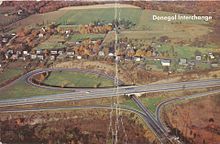
East Donegal Township is a township in northwestern Lancaster County, Pennsylvania, United States. At the 2020 census the population was 8,690.

<span class="mw-page-title-main">Chalfant, Pennsylvania</span> Borough in Pennsylvania, United States

Chalfant is a borough in Allegheny County, Pennsylvania, United States. The population was 800 at the 2010 census.

<span class="mw-page-title-main">Churchill, Pennsylvania</span> Borough in Pennsylvania, United States

Churchill is a borough in Allegheny County, Pennsylvania, United States. The population was 3,011 at the 2010 census. The town was named from the hilltop Beulah Presbyterian Church.

<span class="mw-page-title-main">Elizabeth, Pennsylvania</span> Borough in Pennsylvania, United States

Elizabeth is a borough in Allegheny County, Pennsylvania, on the east bank of the Monongahela River, where Pennsylvania Route 51 crosses, 15 miles (24 km) upstream (south) of Pittsburgh and close to the county line. The population was 1,493 at the 2010 census. The borough of Elizabeth is entirely contained within the 15037 USPS ZIP code. The local school district is the Elizabeth Forward School District. The borough is home to neighborhoods Walker Heights and Town Hill. Elizabeth Borough is the birthplace of Town Hill Hockey established in 1978.

<span class="mw-page-title-main">Donegal Township, Butler County, Pennsylvania</span> Township in Pennsylvania, United States

Donegal Township is a township in Butler County, Pennsylvania, United States. The population was 1,864 at the 2010 census.

<span class="mw-page-title-main">Seven Fields, Pennsylvania</span> Place in Pennsylvania, United States

Seven Fields is a borough in Butler County, Pennsylvania, United States. The population was 2,887 at the 2010 census, an increase from the figure of 1,986 tabulated in 2000.

<span class="mw-page-title-main">Lower Allen Township, Cumberland County, Pennsylvania</span> Township in Pennsylvania, United States

Lower Allen Township is a township in Cumberland County, Pennsylvania, United States. The population was 17,980 at the 2010 census.

<span class="mw-page-title-main">Upper Allen Township, Cumberland County, Pennsylvania</span> Township in Pennsylvania, United States

Upper Allen Township is a township in Cumberland County, Pennsylvania, United States. The population was 23,183 at the 2020 census, up from 18,059 at the 2010 census. The township is the home of Messiah University.

<span class="mw-page-title-main">Lower Tyrone Township, Fayette County, Pennsylvania</span> Township in Pennsylvania, United States

Lower Tyrone Township is a township in Fayette County, Pennsylvania, United States. The population was 1,071 at the 2020 census. It is the location of Linden Hall, an early 20th-century mansion and resort which is listed on the National Register of Historic Places. The Frazier School District serves the township.

<span class="mw-page-title-main">Springfield Township, Fayette County, Pennsylvania</span> Township in Pennsylvania, United States

Springfield Township is a township in Fayette County, Pennsylvania, United States. The population was 2,730 at the 2020 census. The Connellsville Area School District serves the township.

<span class="mw-page-title-main">Stewart Township, Fayette County, Pennsylvania</span> Township in Pennsylvania, United States

Stewart Township is a township in Fayette County, Pennsylvania, United States. It is part of the Pittsburgh Metro Area. The population was 619 at the 2020 census.

<span class="mw-page-title-main">Fannett Township, Franklin County, Pennsylvania</span> Township in Pennsylvania, United States

Fannett Township is a township in Franklin County, Pennsylvania, United States. The population was 2,548 at the 2010 census. The township derives its name as an older variant spelling of Fanad, County Donegal, from early Irish settlement in the area. It was formed before 1762, and until about 1795 included the area now in Metal Township.

<span class="mw-page-title-main">Armagh, Pennsylvania</span> Borough in Pennsylvania, United States

Armagh is a borough in Indiana County in the U.S. state of Pennsylvania. The population was 103 at the 2020 census.

<span class="mw-page-title-main">West Alexander, Pennsylvania</span> Census-designated place in Pennsylvania, United States

West Alexander is a census-designated place in Donegal Township, Washington County, Pennsylvania, and formerly a borough in Washington County. Located less than a mile east of the border with West Virginia, the population was 604 at the 2010 census, just short of double the population of 320 recorded in the 2000 Census. The borough was dissolved into surrounding Donegal Township, effective January 1, 2009.

<span class="mw-page-title-main">Cook Township, Westmoreland County, Pennsylvania</span> Township in Pennsylvania, United States

Cook Township is a township in Westmoreland County, Pennsylvania, United States. The population was 1,888 at the 2020 census, a decrease from 2,250 at the 2010 census, and 2,403 at the 2000 census.

<span class="mw-page-title-main">Donegal Township, Westmoreland County, Pennsylvania</span> Township in Pennsylvania, United States

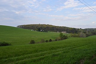
Donegal Township is a township in Westmoreland County, Pennsylvania, United States. The population was 2,192 at the 2020 census, a decrease of 9% compared to 2010.

<span class="mw-page-title-main">Trafford, Pennsylvania</span> Borough in Pennsylvania, United States

Trafford is a borough in Allegheny and Westmoreland counties in the U.S. state of Pennsylvania. Located near Pittsburgh in western Pennsylvania, the borough lies primarily in Westmoreland County; only a small portion extends into Allegheny County. It was incorporated in 1904 from the northernmost corner of North Huntingdon Township, and was named by George Westinghouse for Trafford near Manchester, England. Westinghouse purchased the land in 1902, and the Trafford Foundry began operations on October 3, 1903. The population was 3,174 at the 2010 census. Of this, 3,113 were in Westmoreland County, and only 61 were in Allegheny County.

Lynnwood-Pricedale is a census-designated place (CDP) in Fayette and Westmoreland counties in the commonwealth of Pennsylvania, United States. The population was 2,031 at the 2010 census, down from 2,168 at the 2000 census. The community of Lynwood is located in Fayette County's Washington Township, while Pricedale is part of Westmoreland County's Rostraver Township.

<span class="mw-page-title-main">Seven Springs, Pennsylvania</span> Borough in Pennsylvania, United States

Seven Springs is a borough in Somerset and Fayette counties in the U.S. state of Pennsylvania. The Fayette County portion of the borough and resort are part of the Pittsburgh metropolitan area, and the Somerset County portion is part of the Johnstown Metropolitan Area. The population of the borough was 26 as of the 2010 census, compared to 127 at the 2000 census. Fifteen of the residents in 2010 were in Fayette County, and 11 in Somerset County.

References

  1. "ArcGIS REST Services Directory". United States Census Bureau. Retrieved October 12, 2022.
  2. 1 2 "Census Population API". United States Census Bureau. Retrieved Oct 12, 2022.
  3. 1 2 Bureau, US Census. "City and Town Population Totals: 2020—2021". Census.gov. US Census Bureau. Retrieved July 26, 2022.
  4. Gannett, Henry (1905). The Origin of Certain Place Names in the United States. Govt. Print. Off. pp.  107.
  5. "US Gazetteer files: 2010, 2000, and 1990". United States Census Bureau. 2011-02-12. Retrieved 2011-04-23.
  6. "NowData – NOAA Online Weather Data". National Oceanic and Atmospheric Administration. Retrieved August 8, 2021.
  7. "Station: Donegal 2 NW, PA". U.S. Climate Normals 2020: U.S. Monthly Climate Normals (1991-2020). National Oceanic and Atmospheric Administration. Retrieved August 8, 2021.
  8. "Census of Population and Housing". U.S. Census Bureau. Retrieved 11 December 2013.
  9. 1 2 "U.S. Census website". United States Census Bureau . Retrieved 2008-01-31.
  10. "Incorporated Places and Minor Civil Divisions Datasets: Subcounty Resident Population Estimates: April 1, 2010 to July 1, 2012". Population Estimates. U.S. Census Bureau. Archived from the original on 11 June 2013. Retrieved 11 December 2013.