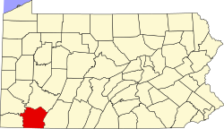
Lynnwood-Pricedale, Pennsylvania

Last updated

Lynnwood-Pricedale, Pennsylvania
USA Pennsylvania location map.svg
Red pog.svg
Lynnwood-Pricedale, Pennsylvania
Location of Lynwood-Pricedale in Pennsylvania
Usa edcp location map.svg
Red pog.svg
Lynnwood-Pricedale, Pennsylvania
Lynnwood-Pricedale, Pennsylvania (the United States)
Coordinates: 40°8′1″N79°51′13″W / 40.13361°N 79.85361°W / 40.13361; -79.85361
CountryUnited States
StatePennsylvania
Counties Fayette
Townships Washington
Area
[1]
  Total1.27 sq mi (3.29 km2)
  Land1.24 sq mi (3.20 km2)
  Water0.04 sq mi (0.09 km2)
Population
 (2020) [2]
  Total2,074
  Density1,677.99/sq mi (647.97/km2)
Time zone UTC-4 (EST)
  Summer (DST) UTC-5 (EDT)
ZIP Code
15012 [3]
Area code 724
FIPS code 42-45732

Lynnwood-Pricedale is a census-designated place (CDP) in Fayette and Westmoreland counties in the Pennsylvania. The population was 2,031 at the 2010 census, [4] down from 2,168 at the 2000 census. The community of Lynwood is located in Fayette County's Washington Township, while Pricedale is part of Westmoreland County's Rostraver Township.

Contents

Geography

Lynnwood-Pricedale is located in the northwestern corner of Fayette County and the southwestern corner of Westmoreland County at 40°8′1″N79°51′13″W / 40.13361°N 79.85361°W / 40.13361; -79.85361 (40.133506, -79.853685). [5] It is bordered by Fairhope and Naomi to the south, and by the boroughs of Belle Vernon and North Belle Vernon to the west. The southwestern border of the CDP is the Monongahela River, which forms the Washington County line. The borough of Dunlevy is directly across the river from Lynnwood-Pricedale.

Interstate 70 passes through the northern part of the CDP, with access from Exit 43 (Pennsylvania Route 201). I-70 leads east 15 miles (24 km) to the Pennsylvania Turnpike at New Stanton and west 25 miles (40 km) to Washington.

According to the U.S. Census Bureau, the Lynnwood-Pricedale CDP has a total area of 1.28 square miles (3.31 km2), of which 1.24 square miles (3.21 km2) is land and 0.04 square miles (0.10 km2), or 2.91%, is water. [4]

Demographics

Historical population
CensusPop.Note
2020 2,074
U.S. Decennial Census [6]

As of the census [7] of 2000, there were 2,168 people, 951 households, and 648 families living in the area. The population density was 1,721.7 inhabitants per square mile (664.8/km2). There were 998 housing units at an average density of 792.5 per square mile (306.0/km2). The racial makeup of the area was 96.82% White, 2.49% African American, 0.14% Native American, 0.32% Asian, 0.05% Pacific Islander, 0.09% from other races, and 0.09% from two or more races. Hispanic or Latino of any race were 0.55% of the population.

There were 951 households, out of which 23.2% had children under the age of 18 living with them, 54.4% were married couples living together, 10.5% had a female householder with no husband present, and 31.8% were non-families. 29.5% of all households were made up of individuals, and 16.5% had someone living alone who was 65 years of age or older. The average household size was 2.28 and the average family size was 2.79.

In the area the population was spread out, with 18.7% under the age of 18, 5.9% from 18 to 24, 24.2% from 25 to 44, 24.4% from 45 to 64, and 26.9% who were 65 years of age or older. The median age was 46 years. For every 100 females, there were 89.0 males. For every 100 females age 18 and over, there were 88.4 males.

The median income for a household in the area was $30,595, and the median income for a family was $34,617. Males had a median income of $29,432 versus $27,188 for females. The per capita income for the area was $17,112. About 5.3% of families and 6.2% of the population were below the poverty line, including 9.0% of those under age 18 and 4.1% of those age 65 or over.

Related Research Articles

<span class="mw-page-title-main">Bullskin Township, Pennsylvania</span> Township in Pennsylvania, United States

Bullskin Township is a township in Fayette County, Pennsylvania, United States. The population was 6,741 at the 2020 census, a decline from the figure of 6,966 tabulated in 2010. It is served by the Connellsville Area School District.

<span class="mw-page-title-main">East Uniontown, Pennsylvania</span> Census-designated place in Pennsylvania, United States

East Uniontown is a census-designated place (CDP) in Fayette County, Pennsylvania, United States. The population was 2,419 at the 2010 census, down from 2,760 at the 2000 census.

<span class="mw-page-title-main">Everson, Pennsylvania</span> Borough in Pennsylvania, United States

Everson is a borough in Fayette County, Pennsylvania, United States. The population was 768 at the 2020 census. It was incorporated in 1903.

<span class="mw-page-title-main">Fayette City, Pennsylvania</span> Borough in Pennsylvania, United States

Fayette City is a borough in Fayette County, Pennsylvania, United States. The population was 502 at the 2020 census, a decline from the figure of 596 tabulated in 2010. It is served by the Belle Vernon Area School District. Some buildings in the town antedate 1820.

<span class="mw-page-title-main">Hiller, Pennsylvania</span> Census-designated place in Pennsylvania, United States

Hiller is an unincorporated community and census-designated place in Fayette County, Pennsylvania, United States. As of the 2010 census, it had a population of 1,155, down from 1,234 at the 2000 census.

<span class="mw-page-title-main">Leith-Hatfield, Pennsylvania</span> Census-designated place in Pennsylvania, United States

Leith-Hatfield is a census-designated place (CDP) in Fayette County, Pennsylvania, United States. The population was 2,546 at the 2010 census, down from 2,820 at the 2000 census. The twin villages of Leith and Hatfield are located in South Union Township.

<span class="mw-page-title-main">Lower Tyrone Township, Pennsylvania</span> Township in Pennsylvania, United States

Lower Tyrone Township is a township in Fayette County, Pennsylvania, United States. The population was 1,069 at the time of the 2020 census.

<span class="mw-page-title-main">Oliver, Pennsylvania</span> Census-designated place in Pennsylvania, United States

Oliver is a census-designated place (CDP) in Fayette County, Pennsylvania, United States. The population was 2,535 at the 2010 census, down from 2,925 at the 2000 census. Oliver is located in North Union Township.

<span class="mw-page-title-main">Perry Township, Fayette County, Pennsylvania</span> Township in Pennsylvania, United States

Perry Township is a township in Fayette County, Pennsylvania, United States. The population was 2,339 at the 2020 census, a decline from the figure of 2,552 tabulated in 2010. The Frazier School District serves the township.

<span class="mw-page-title-main">Republic, Pennsylvania</span> Census-designated place in Pennsylvania, United States

Republic is an unincorporated community and census-designated place (CDP) in Fayette County, Pennsylvania, United States. The population was 1,096 at the 2010 census, down from 1,396 at the 2000 census. The community is in Redstone Township.

<span class="mw-page-title-main">Springhill Township, Fayette County, Pennsylvania</span> Township in Pennsylvania, United States

Springhill Township is a township in Fayette County, Pennsylvania, United States. The population was 2,726 at the 2020 census. The Albert Gallatin Area School District serves the region.

<span class="mw-page-title-main">Upper Tyrone Township, Pennsylvania</span> Township in Pennsylvania, United States

Upper Tyrone Township is a township that is located in Fayette County, Pennsylvania, United States. The population was 1,768 at the time of the 2020 census. It is served by the Southmoreland School District.

<span class="mw-page-title-main">Washington Township, Fayette County, Pennsylvania</span> Township in Pennsylvania, United States

Washington Township is a township in Fayette County, Pennsylvania, United States. The population was 3,899 at the 2020 census, down from 3,902 at the 2010 census.

<span class="mw-page-title-main">Crabtree, Pennsylvania</span> CDP in Pennsylvania, United States

Crabtree is a census-designated place (CDP) and former coal town in Salem Township, Westmoreland County, Pennsylvania, United States. The population was 277 at the 2010 census. It has its own post office, with postal code 15624.

Grapeville is a census-designated place (CDP) in Hempfield Township, Westmoreland County, Pennsylvania, United States. The population was 676 at the time of the 2000 census.

<span class="mw-page-title-main">Harrison City, Pennsylvania</span> Census-designated place in Pennsylvania, United States

Harrison City is a census-designated place (CDP) in Westmoreland County, Pennsylvania, United States. The population was 174 at the 2020 census.

<span class="mw-page-title-main">Herminie, Pennsylvania</span>

Herminie is a census-designated place (CDP) in Sewickley Township, Westmoreland County, Pennsylvania, United States. The population was 856 at the 2000 census.

Lawson Heights is a census-designated place (CDP) in Unity Township, Westmoreland County, Pennsylvania, United States. The population was 2,339 at the 2000 census.

Loyalhanna is a census-designated place (CDP) in Westmoreland County, Pennsylvania, United States. The population was 3,415 at the 2000 census, at which time it was listed as McChesneytown-Loyalhanna, before just becoming the CDP of Loyalhanna for the 2010 census. As of the 2010 census the population was 3,428 residents.

<span class="mw-page-title-main">Rostraver Township, Pennsylvania</span> Township in Pennsylvania, United States

Rostraver Township is a township in Westmoreland County, Pennsylvania, United States. The population was 11,374 at the 2020 census.

References

  1. "ArcGIS REST Services Directory". United States Census Bureau. Retrieved October 12, 2022.
  2. "Census Population API". United States Census Bureau. Retrieved October 12, 2022.
  3. "Lynnwood-Pricedale PA ZIP Code". zipdatamaps.com. 2023. Retrieved May 13, 2023.
  4. 1 2 "Geographic Identifiers: 2010 Census Summary File 1 (G001), Lynnwood-Pricedale CDP, Pennsylvania". American FactFinder. U.S. Census Bureau. Archived from the original on February 13, 2020. Retrieved July 26, 2016.
  5. "US Gazetteer files: 2010, 2000, and 1990". United States Census Bureau. February 12, 2011. Retrieved April 23, 2011.
  6. "Census of Population and Housing". Census.gov. Retrieved June 4, 2016.
  7. "U.S. Census website". United States Census Bureau . Retrieved January 31, 2008.