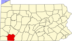
Oliphant Furnace, Pennsylvania

Last updated

Oliphant Furnace, Pennsylvania
USA Pennsylvania location map.svg
Red pog.svg
Oliphant Furnace
Usa edcp location map.svg
Red pog.svg
Oliphant Furnace
Coordinates: 39°50′32″N79°43′33″W / 39.84222°N 79.72583°W / 39.84222; -79.72583
Country United States
State Pennsylvania
County Fayette
Township Georges
Elevation
1,201 ft (366 m)
Time zone UTC-5 (Eastern (EST))
  Summer (DST) UTC-4 (EDT)
GNIS feature ID1182970 [1]

Oliphant Furnace is an unincorporated community and coal town in Fayette County, Pennsylvania, United States. The town began as a mining community which grew up around the cokeworks, which bore the name "Oliphant Furnace" in the 1870s. Other towns with "Furnace" in the name can be found in the region.

Several original saltbox houses which were built by the mining companies can still be found in town, as well as the ruins of the cokeworks just outside town.

Related Research Articles

<span class="mw-page-title-main">Vintondale, Pennsylvania</span> Borough in Pennsylvania, United States

Vintondale is a borough in Cambria County, Pennsylvania, United States. It is part of the Johnstown, Pennsylvania Metropolitan Statistical Area. The population was 414 as of the 2010 census.

<span class="mw-page-title-main">Shade Township, Somerset County, Pennsylvania</span> Township in Pennsylvania, United States

Shade Township is a township in Somerset County, Pennsylvania, United States. The population was 2,452 at the 2020 census. It is part of the Johnstown, Pennsylvania, Metropolitan Statistical Area.

<span class="mw-page-title-main">Anthracite</span> Hard, compact variety of coal

Anthracite, also known as hard coal and black coal, is a hard, compact variety of coal that has a submetallic lustre. It has the highest carbon content, the fewest impurities, and the highest energy density of all types of coal and is the highest ranking of coals.

<span class="mw-page-title-main">Cinderford</span> Human settlement in England

Cinderford is a town and civil parish on the eastern fringe of the Forest of Dean in Gloucestershire, England. The population was 8,777 at the 2021 Census.

<span class="mw-page-title-main">Dillenburg</span> Town in Hesse, Germany

Dillenburg, officially Oranienstadt Dillenburg, is a town in Hesse's Gießen region in Germany. The town was formerly the seat of the old Dillkreis district, which is now part of the Lahn-Dill-Kreis.

<span class="mw-page-title-main">Anthracite iron</span> Substance created by the smelting together of anthracite coal and iron ore

Anthracite iron or anthracite pig iron is the substance created by the smelting together of anthracite coal and iron ore, that is using anthracite coal instead of charcoal to smelt iron ores—and was an important historic advance in the late-1830s, enabling a great acceleration of the industrial revolution in Europe and North America.

<span class="mw-page-title-main">Greenwood Furnace State Park</span> State park in Huntingdon County, Pennsylvania

Greenwood Furnace State Park is a 423-acre (171 ha) Pennsylvania state park in Jackson Township, Huntingdon County, Pennsylvania in the United States. The park is near the historic iron making center of Greenwood Furnace. The park includes the ghost town of Greenwood that grew up around the ironworks, old roads and charcoal hearths. Greenwood Furnace State Park is adjacent to Rothrock State Forest and on the western edge of an area of Central Pennsylvania known as the Seven Mountains. The park is on Pennsylvania Route 305, 20 miles (32 km) south of State College.

<span class="mw-page-title-main">George W. Scranton</span> American politician

George Whitfield Scranton was an American industrialist and politician, a Republican member of the U.S. House of Representatives from Pennsylvania from March 4, 1859, until his death in 1861. Moving to Pennsylvania in the late 1830s to establish an iron furnace, he and his brother Selden T. Scranton are considered the founders of the city of Scranton, Pennsylvania, named for their family. They and two partners established what became known as the Iron & Coal Company. They developed a method of producing T-rails for constructing railroad track, which previously had been imported from England. The innovation led to a boom in production of track and construction of railroads.

<span class="mw-page-title-main">Mount Savage, Maryland</span> Census-designated place in Maryland, United States

Mount Savage is an unincorporated community and census-designated place (CDP) in Allegany County, Maryland, United States. As of the 2010 census it had a population of 873.

Greenwater was an unincorporated community near Death Valley located in the eastern side of the Inyo County, California. It is now a deserted ghost town.

<span class="mw-page-title-main">Corrimal, New South Wales</span> Suburb of Wollongong, New South Wales, Australia

Corrimal is a suburb north of the city of Wollongong, New South Wales, Australia. Corrimal's CBD is situated on the Princes Highway, and several streets adjacent to it. The main shopping centres are Lederer Corrimal and Corrimal Park Mall next to the park on the main thoroughfare of Corrimal itself. Outside this centre is an old locomotive that is affectionately known as "The Green Frog". Corrimal's welcome signs feature The Green Frog, as it ran on the Bulli Colliery Line to Bellambi Haven from 1909 to 1967. To the west is a lawn bowls club and a wealthy foothill neighbourhood of residences bordering bushland.

<span class="mw-page-title-main">Katahdin Iron Works</span> United States historic place

The Katahdin Iron Works is a Maine state historic site located in the unorganized township of the same name. It is the site of an ironworks which operated from 1845 to 1890. In addition to the kilns of the ironworks, the community was served by a railroad and had a 100-room hotel. The site was listed on the National Register of Historic Places in 1969.

Graysdale is an unincorporated community in Patton Township, Centre County, Pennsylvania, United States, located at 40.8130°N 77.9548°W.

Buena Vista is an unincorporated community in Elizabeth Township, Allegheny County, Pennsylvania, United States, located just outside Pittsburgh on the Youghiogheny River. The Great Allegheny Passage rail trail runs through the community. Buena Vista was laid out in 1849 by James B. McGrew for the heirs of Daniel Greenawalt. For a time, it served as a mining town. Like many places in the US with this name, Buena Vista was named for the 1847 Battle of Buena Vista during the Mexican–American War.

The Ghost Town Trail is a rail trail in Western Pennsylvania that runs 36 miles (58 km) between Black Lick, Indiana County, and Ebensburg, Cambria County. Established in 1991 on the right-of-way of the former Ebensburg and Black Lick Railroad, the trail follows the Blacklick Creek and passes through many ghost towns that were abandoned in the early 1900s with the decline of the local coal mining industry. Open year-round to cycling, hiking, and cross-country skiing, the trail is designated a National Recreation Trail by the United States Department of the Interior.

<span class="mw-page-title-main">Ryan, California</span> Unincorporated community in California, United States

Ryan is an unincorporated community in Inyo County, California that is now privately owned and stewarded by the Death Valley Conservancy. A former mining community and company town, Ryan is situated at an elevation of 3,045 feet (928 m) in the Amargosa Range, 8 miles (13 km) northeast of Dante's View and 15 miles (24 km) southeast of Furnace Creek.

<span class="mw-page-title-main">Pittsburgh coal seam</span>

The Pittsburgh Coal Seam is the thickest and most extensive coal bed in the Appalachian Basin; hence, it is the most economically important coal bed in the eastern United States. The Upper Pennsylvanian Pittsburgh coal bed of the Monongahela Group is extensive and continuous, extending over 11,000 mi2 through 53 counties. It extends from Allegany County, Maryland to Belmont County, Ohio and from Allegheny County, Pennsylvania southwest to Putnam County, West Virginia.

<span class="mw-page-title-main">Farrandsville, Pennsylvania</span> Unincorporated community in Pennsylvania, United States

Farrandsville is an unincorporated community in Colebrook Township in Clinton County in the U.S. state of Pennsylvania. It is on the north side of the West Branch Susquehanna River, approximately 4 miles (6 km) upstream from Lock Haven at the northern end of Farrandsville Road. Whisky Run and Lick Run flow through Farrandsville.

<span class="mw-page-title-main">Eckley Brinton Coxe</span> American politician

Eckley Brinton Coxe was an American mining engineer, coal baron, state senator and philanthropist from Pennsylvania. He was a co-founder of the Coxe Brothers and Company coal mining operation which became the largest individual producer of anthracite coal in the United States at the time.

References