Dunbar, Pennsylvania | |
---|---|
Coordinates: 39°58′36″N79°36′53″W / 39.97667°N 79.61472°W | |
Country | United States |
State | Pennsylvania |
County | Fayette |
Established | 1857 |
Government | |
• Mayor | Andrew Lee Lowry |
Area | |
• Total | 0.58 sq mi (1.50 km2) |
• Land | 0.58 sq mi (1.50 km2) |
• Water | 0.00 sq mi (0.00 km2) |
Population | |
• Total | 1,013 |
• Density | 1,752.60/sq mi (676.95/km2) |
Time zone | UTC-4 (EST) |
• Summer (DST) | UTC-5 (EDT) |
ZIP code | 15431 [3] |
Area code | 724 |
Dunbar is a borough in Fayette County, Pennsylvania, United States. The population was 1,013 at the time of the 2020 census, [4] a decline from the figure of 1,042 tabulated in 2010. [5]
Dunbar is named for Col. Thomas Dunbar, who commanded an English force at nearby Jumonville and retreated to Philadelphia after Edward Braddock was defeated by the French and Indians. [6]
Dunbar was originally laid out in 1857, and was incorporated into a borough on June 26, 1883. [7]
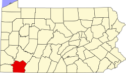
Dunbar is located in north-central Fayette County at 39°58′36″N79°36′53″W / 39.97667°N 79.61472°W , [8] in the valley of Dunbar Creek, a tributary of the Youghiogheny River. It is 5 miles (8 km) south of Connellsville via Woodvale Street and U.S. Route 119. Uniontown, the county seat, is 8 miles (13 km) to the southwest.
According to the United States Census Bureau, Dunbar has a total area of 0.606638 square miles (1.571185 km2), all land. [5]
Census | Pop. | Note | %± |
---|---|---|---|
1890 | 1,381 | — | |
1900 | 1,662 | 20.3% | |
1910 | 1,970 | 18.5% | |
1920 | 1,607 | −18.4% | |
1930 | 1,357 | −15.6% | |
1940 | 1,390 | 2.4% | |
1950 | 1,363 | −1.9% | |
1960 | 1,536 | 12.7% | |
1970 | 1,499 | −2.4% | |
1980 | 1,369 | −8.7% | |
1990 | 1,213 | −11.4% | |
2000 | 1,219 | 0.5% | |
2010 | 1,042 | −14.5% | |
2020 | 1,013 | −2.8% | |
2021 (est.) | 999 | [4] | −1.4% |
Sources: [9] [10] [11] [2] |
As of the 2000 census, [10] there were 1,219 people, 513 households, and 343 families residing in the borough. The population density was 1,879.0 inhabitants per square mile (725.5/km2). There were 576 housing units at an average density of 887.9 per square mile (342.8/km2). The racial makeup of the borough was 99.26% White, 0.41% African American, 0.08% Native American, 0.08% Asian, and 0.16% from two or more races.
There were 513 households, out of which 28.1% had children under the age of 18 living with them, 48.3% were married couples living together, 14.0% had a female householder with no husband present, and 33.1% were non-families. 29.2% of all households were made up of individuals, and 15.2% had someone living alone who was 65 years of age or older. The average household size was 2.36 and the average family size was 2.93.
In the borough the population was spread out, with 22.1% under the age of 18, 8.6% from 18 to 24, 26.9% from 25 to 44, 23.8% from 45 to 64, and 18.6% who were 65 years of age or older. The median age was 40 years. For every 100 females, there were 85.0 males. For every 100 females age 18 and over, there were 83.0 males.
The median income for a household in the borough was $25,718, and the median income for a family was $30,197. Males had a median income of $27,411 versus $18,507 for females. The per capita income for the borough was $14,176. About 5.9% of families and 11.1% of the population were below the poverty line, including 7.1% of those under age 18 and 16.6% of those age 65 or over.
Brownsville Township is a township in Fayette County, Pennsylvania, United States. The population was 536 at the 2020 census, a decline from the figure of 683 tabulated in 2010. It is served by the Brownsville School District.
Connellsville Township is a township in Fayette County, Pennsylvania, United States. The population was 2,073 at the 2020 census, a decline from the figure of 2,391 tabulated in 2010.
Dawson is a borough in Fayette County, Pennsylvania, United States. The population was 352 at the 2020 census, a decline from the figure of 367 tabulated in 2010.
Dunbar Township is a township in Fayette County, Pennsylvania, United States. The population was 6,671 at the 2020 census, a decline from the figure of 7,126 tabulated in 2010.
Everson is a borough in Fayette County, Pennsylvania, United States. The population was 768 at the 2020 census. It was incorporated in 1903.
Fairchance is a borough in Fayette County, Pennsylvania, United States. The population was 1,889 at the 2020 census, a decline from the figure of 1,975 tabulated in 2010. It is served by the Albert Gallatin Area School District.
Fayette City is a borough in Fayette County, Pennsylvania, United States. The population was 502 at the 2020 census, a decline from the figure of 596 tabulated in 2010. It is served by the Belle Vernon Area School District. Some buildings in the town antedate 1820.
Georges Township is a township in Fayette County, Pennsylvania, United States. The population was 6,346 at the 2020 census, a decline from the figure of 6,612 tabulated in 2010. It is served by the Albert Gallatin Area School District.
Jefferson Township is a township in Fayette County, Pennsylvania, United States. The population was 2,007 at the 2020 census, a decline from the figure of 2,008 tabulated in 2010. It is named for former president Thomas Jefferson, and many of the township's streets are named after other U.S. presidents. Frazier School District serves the area.
Lower Tyrone Township is a township in Fayette County, Pennsylvania, United States. The population was 1,069 at the time of the 2020 census.
Markleysburg is a borough in Fayette County, Pennsylvania, United States. The population was 246 at the 2020 census. The borough is served by the Uniontown Area School District.
Masontown is a borough in Fayette County, Pennsylvania, United States. It is part of the Pittsburgh Metro Area. The population of the borough was 3,274 at the 2020 census. It is served by the Albert Gallatin Area School District. Masontown is a small crossroads for the rural portions of western Fayette County, and it contains a small shopping center and a grocery store within its business district.
Perryopolis is a borough in Fayette County, Pennsylvania, United States. The borough is part of the Pittsburgh metropolitan area. The population was 1,705 at the 2020 census.
Smithfield is a borough in Fayette County, Pennsylvania, United States. The population was 830 at the 2020 census. It is served by the Albert Gallatin Area School District. The town's largest employer is a small wire-producing plant run by Nelson Steel.
South Connellsville is a borough in Fayette County, Pennsylvania, United States. The population was 1,919 at the 2020 census, a decline from the figure of 1,970 tabulated in 2010.
Upper Tyrone Township is a township that is located in Fayette County, Pennsylvania, United States. The population was 1,768 at the time of the 2020 census. It is served by the Southmoreland School District.
Vanderbilt is a borough in Fayette County, Pennsylvania, United States. The population was 414 at the 2020 census, a decline from the figure of 476 tabulated in 2010. The town is named for the railroad tycoon Cornelius Vanderbilt and is served by the Connellsville Area School District.
Dunlevy is a borough in Washington County, Pennsylvania, United States. The population was 369 at the 2020 census.
Lynnwood-Pricedale is a census-designated place (CDP) in Fayette and Westmoreland counties in the Pennsylvania. The population was 2,031 at the 2010 census, down from 2,168 at the 2000 census. The community of Lynwood is located in Fayette County's Washington Township, while Pricedale is part of Westmoreland County's Rostraver Township.
Seven Springs is a borough in Somerset and Fayette counties in the U.S. state of Pennsylvania. The Fayette County portion of the borough and resort are part of the Pittsburgh metropolitan area, and the Somerset County portion is part of the Johnstown Metropolitan Area. The population of the borough was 26 as of the 2010 census, compared to 127 at the 2000 census. Fifteen of the residents in 2010 were in Fayette County, and 11 in Somerset County.
{{cite web}}
: |last1=
has generic name (help)