Brownsville Township, Pennsylvania

Last updated

Brownsville Township
National Pike just east of Brownsville.jpg
Scene along the National Road
Map of Brownsville Township, Fayette County, Pennsylvania Highlighted.png
Location of Brownsville Township in Fayette County
Map of Pennsylvania highlighting Fayette County.svg
Location of Fayette County in Pennsylvania
CountryUnited States
State Pennsylvania
County Fayette
Area
[1]
  Total1.55 sq mi (4.01 km2)
  Land1.50 sq mi (3.89 km2)
  Water0.04 sq mi (0.12 km2)
Population
 (2020) [2]
  Total536 Decrease2.svg
  Estimate 
(2022) [2]
524
  Density441.41/sq mi (170.42/km2)
Time zone UTC-4 (EST)
  Summer (DST) UTC-5 (EDT)
Area code 724
Website www.brownsvilletownship.org

Brownsville Township is a township in Fayette County, Pennsylvania, United States. The population was 536 at the 2020 census, [2] a decline from the figure of 683 tabulated in 2010. [3] It is served by the Brownsville School District.

Contents

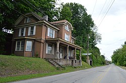
The township contains the populated places of Knoxville and Century. [4]

Geography

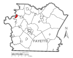
Brownsville Township is in northwestern Fayette County; it is bordered to the west by the borough of Brownsville, to the southwest by Luzerne Township, to the southeast by Redstone Township, and to the northeast by Jefferson Township. On the northwest, across the Monongahela River, is the borough of West Brownsville in Washington County. Dunlap Creek forms the boundary with Luzerne Township and part of the boundary with Brownsville borough, while Redstone Creek forms the boundary with Jefferson Township; both creeks are tributaries of the Monongahela.

U.S. Route 40 crosses the township, leading northwest into Brownsville borough and southeast to Uniontown, the Fayette County seat. Downtown Pittsburgh is 40 miles (64 km) to the north.

According to the United States Census Bureau, the township has a total area of 1.55 square miles (4.01 km2), of which 1.50 square miles (3.89 km2) is land and 0.05 square miles (0.12 km2), or 2.91%, is water. [3]

Demographics

Historical population
CensusPop.Note
2010 683
2020 536−21.5%
2022 (est.)524 [2] −2.2%
U.S. Decennial Census [5]

As of the 2000 census, [6] there were 769 people, 325 households, and 216 families residing in the township. The population density was 470.7 inhabitants per square mile (181.7/km2). There were 362 housing units at an average density of 221.6 per square mile (85.6/km2). The racial makeup of the township was 94.80% White, 3.90% African American, 0.13% Asian, 0.52% from other races, and 0.65% from two or more races. Hispanic or Latino of any race were 0.65% of the population.

There were 325 households, out of which 24.0% had children under the age of 18 living with them, 48.3% were married couples living together, 15.1% had a female householder with no husband present, and 33.5% were non-families. 29.2% of all households were made up of individuals, and 15.7% had someone living alone who was 65 years of age or older. The average household size was 2.34 and the average family size was 2.88.

In the township the population was spread out, with 20.2% under the age of 18, 6.9% from 18 to 24, 25.6% from 25 to 44, 25.2% from 45 to 64, and 22.1% who were 65 years of age or older. The median age was 43 years. For every 100 females there were 82.7 males. For every 100 females age 18 and over, there were 84.4 males.

The median income for a household in the township was $31,917, and the median income for a family was $37,500. Males had a median income of $29,000 versus $20,250 for females. The per capita income for the township was $16,777. About 9.7% of families and 14.8% of the population were below the poverty line, including 25.3% of those under age 18 and 12.0% of those age 65 or over.

Related Research Articles

<span class="mw-page-title-main">Forward Township, Allegheny County, Pennsylvania</span> Township of Allegheny County, Pennsylvania

Forward Township is a township in Allegheny County, Pennsylvania, United States. The population was 3,068 at the 2020 census. The township is named after Walter Forward, U.S. Secretary of the Treasury from 1841 to 1843.

<span class="mw-page-title-main">Belle Vernon, Pennsylvania</span> Borough in Pennsylvania, United States

Belle Vernon is a borough in Fayette County, Pennsylvania, United States. It is situated along the Monongahela River, abutting two other counties, Westmoreland to the north and Washington across the river. As of the 2020 census, Belle Vernon had a population of 1,025.

<span class="mw-page-title-main">Connellsville Township, Pennsylvania</span> Township in Pennsylvania, United States

Connellsville Township is a township in Fayette County, Pennsylvania, United States. The population was 2,073 at the 2020 census, a decline from the figure of 2,391 tabulated in 2010.

<span class="mw-page-title-main">Fayette City, Pennsylvania</span> Borough in Pennsylvania, United States

Fayette City is a borough in Fayette County, Pennsylvania, United States. The population was 502 at the 2020 census, a decline from the figure of 596 tabulated in 2010. It is served by the Belle Vernon Area School District. Some buildings in the town antedate 1820.

<span class="mw-page-title-main">Franklin Township, Fayette County, Pennsylvania</span> Township in Pennsylvania, United States

Franklin Township is a township in Fayette County, Pennsylvania, United States. The population was 2,380 at the 2020 census, a decline from the figure of 2,528 tabulated in 2010. The township is served by the Uniontown Area School District.

<span class="mw-page-title-main">German Township, Fayette County, Pennsylvania</span> Township in Pennsylvania, United States

German Township is a township in Fayette County, Pennsylvania, United States. The population was 4,672 at the 2020 census, a decline from the figure of 5,097 tabulated in 2010. McClellandtown is the township's largest village. The Albert Gallatin Area School District serves the region.

<span class="mw-page-title-main">Hiller, Pennsylvania</span> Census-designated place in Pennsylvania, United States

Hiller is an unincorporated community and census-designated place in Fayette County, Pennsylvania, United States. As of the 2010 census, it had a population of 1,155, down from 1,234 at the 2000 census.

<span class="mw-page-title-main">Jefferson Township, Fayette County, Pennsylvania</span> Township in Pennsylvania, United States

Jefferson Township is a township in Fayette County, Pennsylvania, United States. The population was 2,007 at the 2020 census, a decline from the figure of 2,008 tabulated in 2010. It is named for former president Thomas Jefferson, and many of the township's streets are named after other U.S. presidents. Frazier School District serves the area.

<span class="mw-page-title-main">Luzerne Township, Pennsylvania</span> Township in Pennsylvania, United States

Luzerne Township is a township in Fayette County, Pennsylvania, United States. The population was 5,585 at the 2020 census, down from 5,965 at the 2010 census.

<span class="mw-page-title-main">Menallen Township, Fayette County, Pennsylvania</span> Township in Pennsylvania, United States

Menallen Township is a township in Fayette County, Pennsylvania, United States. It is part of the Pittsburgh metropolitan area. The population was 4,095 at the 2020 census, a decline from the figure of 4,205 tabulated in 2010. The Uniontown Area School District serves the region.

<span class="mw-page-title-main">Redstone Township, Pennsylvania</span> Township in Pennsylvania, United States

Redstone Township is a township in Fayette County, Pennsylvania, United States. The population was 5,077 at the 2020 census, a decline from the figure of 5,566 tabulated in 2010. The Brownsville Area School District serves the region.

<span class="mw-page-title-main">Republic, Pennsylvania</span> Census-designated place in Pennsylvania, United States

Republic is an unincorporated community and census-designated place (CDP) in Fayette County, Pennsylvania, United States. The population was 1,096 at the 2010 census, down from 1,396 at the 2000 census. The community is in Redstone Township.

<span class="mw-page-title-main">Springfield Township, Fayette County, Pennsylvania</span> Township in Pennsylvania, United States

Springfield Township is a township in Fayette County, Pennsylvania, United States. The population was 2,731 at the 2020 census. The Connellsville Area School District serves the township.

<span class="mw-page-title-main">Springhill Township, Fayette County, Pennsylvania</span> Township in Pennsylvania, United States

Springhill Township is a township in Fayette County, Pennsylvania, United States. The population was 2,726 at the 2020 census. The Albert Gallatin Area School District serves the region.

<span class="mw-page-title-main">Monongahela Township, Pennsylvania</span> Township in Pennsylvania, United States

Monongahela Township is a township in Greene County, Pennsylvania, United States. The population was 1,483 at the 2020 census, down from 1,572 at the 2010 census.

<span class="mw-page-title-main">Centerville, Washington County, Pennsylvania</span> Borough in Washington County, Pennsylvania, United States

Centerville is a borough in Washington County, Pennsylvania, United States. The population was 3,254 at the 2020 census.

<span class="mw-page-title-main">Dunlevy, Pennsylvania</span> Borough in Pennsylvania, United States

Dunlevy is a borough in Washington County, Pennsylvania, United States. The population was 369 at the 2020 census.

<span class="mw-page-title-main">Roscoe, Pennsylvania</span> Borough in Pennsylvania, United States

Roscoe is a borough in Washington County, Pennsylvania, United States. The population was 716 at the 2020 census.

Lynnwood-Pricedale is a census-designated place (CDP) in Fayette and Westmoreland counties in the Pennsylvania. The population was 2,031 at the 2010 census, down from 2,168 at the 2000 census. The community of Lynwood is located in Fayette County's Washington Township, while Pricedale is part of Westmoreland County's Rostraver Township.

<span class="mw-page-title-main">Brownsville Area School District</span> School district in Fayette County, Penn.

The Brownsville Area School District spans portions of two counties. In Fayette County, Pennsylvania it covers the Borough of Brownsville and Brownsville Township, Luzerne Township and Redstone Township in Fayette County. In Washington County, Pennsylvania it covers a portion of the Borough of West Brownsville. Brownsville Area School District encompasses approximately 57 square miles. According to 2000 federal census data, it served a resident population of 15,097. By 2010, the district's population declined to 14,959 people per the US Census Bureau. The educational attainment levels for the Brownsville Area School District population were 80% high school graduates and 9.9% college graduates. The district is one of the 500 public school districts of Pennsylvania.

References

  1. "2016 U.S. Gazetteer Files". United States Census Bureau. Retrieved August 13, 2017.
  2. 1 2 3 4 Bureau, US Census. "City and Town Population Totals: 2020-2022". Census.gov. US Census Bureau. Retrieved December 1, 2023.
  3. 1 2 "Geographic Identifiers: 2010 Census Summary File 1 (G001), Brownsville township, Fayette County, Pennsylvania". American FactFinder. U.S. Census Bureau. Archived from the original on February 13, 2020. Retrieved July 8, 2016.
  4. USGS California (PA) quadrangle (2013)
  5. "Census of Population and Housing". Census.gov. Retrieved June 4, 2016.
  6. "U.S. Census website". United States Census Bureau . Retrieved January 31, 2008.

40°01′00″N79°52′16″W / 40.01667°N 79.87111°W / 40.01667; -79.87111