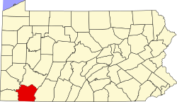
New Salem, Fayette County, Pennsylvania

Last updated

New Salem, Fayette County,
Pennsylvania
USA Pennsylvania location map.svg
Red pog.svg
New Salem
Usa edcp location map.svg
Red pog.svg
New Salem
Coordinates: 39°55′30″N79°50′14″W / 39.92500°N 79.83722°W / 39.92500; -79.83722
Country United States
State Pennsylvania
County Fayette
Township Menallen
Area
[1]
  Total1.16 sq mi (3.01 km2)
  Land1.16 sq mi (3.01 km2)
  Water0.00 sq mi (0.00 km2)
Elevation
1,070 ft (330 m)
Population
 (2020) [2]
  Total499
  Density429.80/sq mi (165.96/km2)
Time zone UTC-5 (Eastern (EST))
  Summer (DST) UTC-4 (EDT)
FIPS code 42-54040
GNIS feature ID1182365

New Salem is an unincorporated community and census-designated place located in Menallen Township, Fayette County, Pennsylvania, United States. It was formerly part of the New Salem-Buffington CDP, before it was split into two separate CDPs for the 2010 census. The population of New Salem was 579 as of the 2010 census. [3]

Contents

Geography

New Salem is located in western Fayette County, in the southwestern part of Menallen Township. It is bordered to the west by Buffington and to the south, across Dunlap Creek, by German Township. New Salem Road leads southeast 7 miles (11 km) to Uniontown, the county seat, and northwest 3 miles (5 km) to Pennsylvania Route 166 south of Republic. According to the U.S. Census Bureau, the New Salem CDP has an area of 1.2 square miles (3.0 km2), all land. [3]

Demographics

Historical population
CensusPop.Note
2020 499
U.S. Decennial Census

Related Research Articles

<span class="mw-page-title-main">Fayette County, Pennsylvania</span> County in Pennsylvania, United States

Fayette County is a county in the Commonwealth of Pennsylvania. It is located in southwestern Pennsylvania, adjacent to Maryland and West Virginia. As of the 2020 census, the population was 128,804. Its county seat is Uniontown. The county was created on September 26, 1783, from part of Westmoreland County and named after the Marquis de Lafayette.

<span class="mw-page-title-main">East Uniontown, Pennsylvania</span> Census-designated place in Pennsylvania, United States

East Uniontown is a census-designated place (CDP) in Fayette County, Pennsylvania, United States. The population was 2,419 at the 2010 census, down from 2,760 at the 2000 census.

<span class="mw-page-title-main">German Township, Fayette County, Pennsylvania</span> Township in Pennsylvania, United States

German Township is a township in Fayette County, Pennsylvania, United States. The population was 4,666 at the 2020 census, a decline from the figure of 5,097 tabulated in 2010. McClellandtown is the township's largest village. The Albert Gallatin Area School District serves the region.

<span class="mw-page-title-main">Hiller, Pennsylvania</span> Census-designated place in Pennsylvania, United States

Hiller is an unincorporated community and census-designated place in Fayette County, Pennsylvania, United States. As of the 2010 census, it had a population of 1,155, down from 1,234 at the 2000 census.

<span class="mw-page-title-main">Leith-Hatfield, Pennsylvania</span> Census-designated place in Pennsylvania, United States

Leith-Hatfield is a census-designated place (CDP) in Fayette County, Pennsylvania, United States. The population was 2,546 at the 2010 census, down from 2,820 at the 2000 census. The twin villages of Leith and Hatfield are located in South Union Township.

<span class="mw-page-title-main">Menallen Township, Fayette County, Pennsylvania</span> Township in Pennsylvania, United States

Menallen Township is a township in Fayette County, Pennsylvania, United States. It is part of the Pittsburgh Metropolitan Area. The population was 4,092 at the 2020 census, a decline from the figure of 4,205 tabulated in 2010. The Uniontown Area School District serves the region.

<span class="mw-page-title-main">New Salem-Buffington, Pennsylvania</span> Former CDP in Pennsylvania, United States

New Salem-Buffington was a census-designated place (CDP) in Fayette County, Pennsylvania, United States and part of the Pittsburgh Metro Area. The population was 808 at the 2000 census. For the 2010 census the area was split into two CDPs, New Salem and Buffington. Both communities are located in Menallen Township.

<span class="mw-page-title-main">Oliver, Pennsylvania</span> Census-designated place in Pennsylvania, United States

Oliver is a census-designated place (CDP) in Fayette County, Pennsylvania, United States. The population was 2,535 at the 2010 census, down from 2,925 at the 2000 census. Oliver is located in North Union Township.

<span class="mw-page-title-main">McAlisterville, Pennsylvania</span> Census-designated place in Pennsylvania, United States

McAlisterville is an unincorporated community and census-designated place (CDP) in Fayette Township, Juniata County, Pennsylvania, United States. The population was 971 at the 2010 census.

Lynnwood-Pricedale is a census-designated place (CDP) in Fayette and Westmoreland counties in the commonwealth of Pennsylvania, United States. The population was 2,031 at the 2010 census, down from 2,168 at the 2000 census. The community of Lynwood is located in Fayette County's Washington Township, while Pricedale is part of Westmoreland County's Rostraver Township.

<span class="mw-page-title-main">Farmington, Pennsylvania</span> Census-designated place in Pennsylvania, United States

Farmington is an unincorporated community and census-designated place in Wharton Township, Fayette County, Pennsylvania, United States.

Lemont Furnace is an unincorporated community and census-designated place in North Union Township, Fayette County, Pennsylvania, United States. It is located 3 miles (5 km) northeast of the city of Uniontown and approximately 60 miles (97 km) southeast of Pittsburgh. The community is part of the Pittsburgh metropolitan area. At the 2010 census, the population of Lemont Furnace was 827.

Fivepointville is an unincorporated community and census-designated place (CDP) in Brecknock Township, Lancaster County, Pennsylvania, United States. As of the 2010 census, the population was 1,156. The town is named for its position at an intersection of five separate roads.

<span class="mw-page-title-main">Enlow, Pennsylvania</span> Census-designated place in Pennsylvania, United States

Enlow is a census-designated place (CDP) in Allegheny County, Pennsylvania, United States. The community was formerly part of the Imperial-Enlow CDP, which was split into two separate CDPs as of the 2010 census. The population was 1,138 at the 2020 census.

Grindstone is an unincorporated community and census-designated place that is located in Jefferson and Redstone townships, in Fayette County, Pennsylvania, United States. The community was part of the Grindstone-Rowes Run CDP before it was split into two separate CDPs for the 2010 census. In 2010, the population was 498.

Buffington is an unincorporated community and census-designated place in Menallen Township, Fayette County, Pennsylvania, United States. The community was part of the New Salem-Buffington CDP, before it was split into two separate CDPs for the 2010 census. The population was 292 as of the 2010 census.

Allison is an unincorporated community and census-designated place (CDP), which is located in Luzerne and Redstone townships in Fayette County, Pennsylvania, United States. It is situated 3 miles (5 km) south of the borough of Brownsville.

Edenborn is an unincorporated community and census-designated place in German Township, Fayette County, Pennsylvania, United States. It is located along Pennsylvania Route 166, just north of Pennsylvania Route 21. Uniontown is 10 miles (16 km) to the east, Brownsville is 11 miles (18 km) to the north, and Waynesburg is 18 miles (29 km) to the west. As of the 2010 census, the population was 294.

Fairhope is an unincorporated community and census-designated place in Washington Township, Fayette County, Pennsylvania, United States. It is in the northwestern corner of Fayette County, bordered by Lynwood to the northwest, Naomi to the west, and Arnold City to the east. The borough of Belle Vernon is 2 miles (3 km) to the northwest. Pennsylvania Route 201 passes through Fairhope, leading north to Interstate 70 and south to Fayette City. As of the 2010 census, the population of Fairhope was 1,151.

Smock is an unincorporated community and census-designated place that is located in Franklin and Menallen townships in Fayette County, Pennsylvania, United States. Situated roughly halfway between the borough of Perryopolis and the city of Uniontown, it is part of the Pittsburgh metropolitan area.

References

  1. "ArcGIS REST Services Directory". United States Census Bureau. Retrieved October 12, 2022.
  2. "Census Population API". United States Census Bureau. Retrieved October 12, 2022.
  3. 1 2 "Geographic Identifiers: 2010 Census Summary File 1 (G001), New Salem CDP, Pennsylvania". American FactFinder. U.S. Census Bureau. Archived from the original on February 13, 2020. Retrieved July 27, 2016.