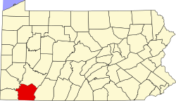
Bear Rocks, Pennsylvania

Last updated

Bear Rocks, Pennsylvania
USA Pennsylvania location map.svg
Red pog.svg
Bear Rocks
Usa edcp location map.svg
Red pog.svg
Bear Rocks
Coordinates: 40°07′35″N79°27′54″W / 40.12639°N 79.46500°W / 40.12639; -79.46500
Country United States
State Pennsylvania
County Fayette
Township Bullskin
Area
[1]
  Total3.24 sq mi (8.39 km2)
  Land3.24 sq mi (8.39 km2)
  Water0.00 sq mi (0.00 km2)
Elevation
1,847 ft (563 m)
Population
 (2020) [2]
  Total1,005
  Density310.38/sq mi (119.84/km2)
Time zone UTC-5 (Eastern (EST))
  Summer (DST) UTC-4 (EDT)
FIPS code 42-04616
GNIS feature ID2633768

Bear Rocks is an unincorporated community and census-designated place in Bullskin Township, Fayette County, Pennsylvania, United States. [3] It is located along the south side of Pennsylvania Route 31 in northern Fayette County, on the western slope of Chestnut Ridge. The elevation ranges from 1,150 feet (350 m) above sea level at the northwestern end of the community, in the valley of Jacobs Creek, to 2,196 feet (669 m) near the southeastern corner of the community, at the intersection of Kreinbrook Hill Road and Sky Top Road.

Contents

In 1977, Bear Rocks was the site of a controversial murder. A local man, David Munchinski, was found guilty of the crime and served 26 years in prison. He was later found to have been wrongfully convicted and was released. [4] [5] [6] [7] [8]

Demographics

As of the 2010 census, the population of the CDP was 1,048. [9]

Historical population
CensusPop.Note
2020 1,005
U.S. Decennial Census [10] [2]

Related Research Articles

<span class="mw-page-title-main">Westmoreland County, Pennsylvania</span> County in Pennsylvania, United States

Westmoreland County is a county in the Commonwealth of Pennsylvania, United States. As of the 2020 census, the population was 364,663. The county seat is Greensburg and the most populous community is Hempfield Township. It is named after Westmorland, a historic county of England.

<span class="mw-page-title-main">Fayette County, Pennsylvania</span> County in Pennsylvania, United States

Fayette County is a county in the Commonwealth of Pennsylvania. It is located in southwestern Pennsylvania, adjacent to Maryland and West Virginia. As of the 2020 census, the population was 128,804. Its county seat is Uniontown. The county was created on September 26, 1783, from part of Westmoreland County and named after the Marquis de Lafayette.

<span class="mw-page-title-main">Collier Township, Allegheny County, Pennsylvania</span> Township in Pennsylvania, United States

Collier Township is a township in Allegheny County, Pennsylvania, United States. The population was 8,931 at the 2020 census, an increase over the figure of 7,080 tabulated in 2010.

<span class="mw-page-title-main">Findlay Township, Allegheny County, Pennsylvania</span> Township in Pennsylvania, United States

Findlay Township is a township located west of Pittsburgh in Allegheny County, Pennsylvania. The population was 6,370 at the 2020 census.

<span class="mw-page-title-main">North Fayette Township, Pennsylvania</span> Township in Pennsylvania, United States

North Fayette Township is a township in Allegheny County, Pennsylvania, United States. The township is a suburb of Pittsburgh. The population was 13,680 at the 2010 census. The township has been home to the Park Lane Office center since 1989.

<span class="mw-page-title-main">Upper St. Clair Township, Pennsylvania</span> First Class Township with home rule in Pennsylvania, United States

Upper St. Clair is a township with home rule status in southern Allegheny County, Pennsylvania, United States, located approximately 8 miles (13 km) south of Downtown Pittsburgh. It is known for being an affluent suburb with a nationally recognized school district. As of the 2010 census, the township population was 19,229.

<span class="mw-page-title-main">Bullskin Township, Fayette County, Pennsylvania</span> Township in Pennsylvania, United States

Bullskin Township is a township in Fayette County, Pennsylvania, United States. The population was 6,729 at the 2020 census, a decline from the figure of 6,966 tabulated in 2010. It is served by the Connellsville Area School District.

<span class="mw-page-title-main">Hiller, Pennsylvania</span> Census-designated place in Pennsylvania, United States

Hiller is an unincorporated community and census-designated place in Fayette County, Pennsylvania, United States. As of the 2010 census, it had a population of 1,155, down from 1,234 at the 2000 census.

<span class="mw-page-title-main">Leith-Hatfield, Pennsylvania</span> Census-designated place in Pennsylvania, United States

Leith-Hatfield is a census-designated place (CDP) in Fayette County, Pennsylvania, United States. The population was 2,546 at the 2010 census, down from 2,820 at the 2000 census. The twin villages of Leith and Hatfield are located in South Union Township.

<span class="mw-page-title-main">Oliver, Pennsylvania</span> Census-designated place in Pennsylvania, United States

Oliver is a census-designated place (CDP) in Fayette County, Pennsylvania, United States. The population was 2,535 at the 2010 census, down from 2,925 at the 2000 census. Oliver is located in North Union Township.

<span class="mw-page-title-main">Republic, Pennsylvania</span> Census-designated place in Pennsylvania, United States

Republic is an unincorporated community and census-designated place (CDP) in Fayette County, Pennsylvania, United States. The population was 1,096 at the 2010 census, down from 1,396 at the 2000 census. The community is in Redstone Township.

<span class="mw-page-title-main">Saltlick Township, Pennsylvania</span> Township in Pennsylvania, United States

Saltlick Township is a township that is located in Fayette County, Pennsylvania, United States. The population was 3,037 according to the 2020 census, a decline of twelve percent from the 2010 census, and eighteen percent from the 2000 census. It is served by the Connellsville Area School District.

<span class="mw-page-title-main">California, Pennsylvania</span> Borough in Pennsylvania, United States

California is a borough on the Monongahela River in Washington County, Pennsylvania, United States. The population was 5,479 as of the 2020 census. It is part of the Pittsburgh metropolitan area.

<span class="mw-page-title-main">Imperial, Pennsylvania</span> Census-designated place in Pennsylvania, United States

Imperial is a census-designated place (CDP) in Allegheny County, Pennsylvania, United States and part of the Pittsburgh metropolitan area. The population was 2,722 at the 2020 census. The CDP is located in North Fayette and Findlay Townships, and geographically close to Pittsburgh International Airport.

<span class="mw-page-title-main">Clinton, Pennsylvania</span> Census-designated place in Pennsylvania, United States

Clinton is a census-designated place in Findlay Township, Allegheny County, Pennsylvania, United States. It had a population of 905 at the 2020 census. The community is located adjacent to the Pittsburgh International Airport within the Pittsburgh metropolitan area.

<span class="mw-page-title-main">Arnold City, Pennsylvania</span> Census-designated place in Pennsylvania, United States

Arnold City is an unincorporated community and census-designated place in Washington Township, Fayette County, Pennsylvania, United States. It is located approximately 3 miles (5 km) east of the borough of Belle Vernon, in far northwestern Fayette County. As of the 2010 census, the population of Arnold City was 498.

Lemont Furnace is an unincorporated community and census-designated place in North Union Township, Fayette County, Pennsylvania, United States. It is located 3 miles (5 km) northeast of the city of Uniontown and approximately 60 miles (97 km) southeast of Pittsburgh. The community is part of the Pittsburgh metropolitan area. At the 2010 census, the population of Lemont Furnace was 827.

<span class="mw-page-title-main">Enlow, Pennsylvania</span> Census-designated place in Pennsylvania, United States

Enlow is a census-designated place (CDP) in Allegheny County, Pennsylvania, United States. The community was formerly part of the Imperial-Enlow CDP, which was split into two separate CDPs as of the 2010 census. The population was 1,138 at the 2020 census.

Rowes Run is an unincorporated community and census-designated place in Redstone Township, Fayette County, Pennsylvania, United States. As of the 2010 census, its population was 564. The community was part of the Grindstone-Rowes Run CDP before it was split into two separate CDPs for the 2010 census.

Grindstone is an unincorporated community and census-designated place that is located in Jefferson and Redstone townships, in Fayette County, Pennsylvania, United States. The community was part of the Grindstone-Rowes Run CDP before it was split into two separate CDPs for the 2010 census. In 2010, the population was 498.

References

  1. "ArcGIS REST Services Directory". United States Census Bureau. Retrieved October 12, 2022.
  2. 1 2 "Census Population API". United States Census Bureau. Retrieved October 12, 2022.
  3. "History of Bullskin Township". Bullskin Township Historical Society. Retrieved October 29, 2023.
  4. Gazarik, Richard and Cholodofsky, Rich. "Bear Rocks Slayings: Key evidence raises doubt about guilt of Munchinski". Tribune-Review, Pittsburgh PA. Retrieved October 29, 2023.{{cite web}}: CS1 maint: multiple names: authors list (link)
  5. Ward, Paula Reed. "Lawsuit Settled Against Fayette County, State Police in Wrongful Conviction of Man Imprisoned For 26 Years". Tribune-Review, Pittsburgh PA. Retrieved October 29, 2023.
  6. Possley, Maurice. "David Munchinski". The National Registry of Exonerations. Newkirk Center for Science & Society at University of California Irvine, the University of Michigan Law School and Michigan State University College of Law. Retrieved October 29, 2023.
  7. ops@our-hometown.com (April 8, 2022). "Wrongful conviction suit settled in 1977 Bear Rocks murder case". The Daily Courier, Connellsvile PA. Retrieved October 30, 2023.
  8. Ove, Thorsten (April 11, 2022). "The long, sad tale of David Munchinski, cleared of double murder, ends in death and an $8 million payout". Pittsburgh Post-Gazette. Retrieved October 30, 2023.
  9. "Geographic Identifiers: 2010 Census Summary File 1 (G001), Bear Rocks CDP, Pennsylvania". American FactFinder. U.S. Census Bureau. Archived from the original on February 13, 2020. Retrieved July 22, 2016.
  10. "Census of Population and Housing". Census.gov. Retrieved June 4, 2016.