Grindstone, Pennsylvania

Last updated

Grindstone, Pennsylvania
Nickname: 
Ava Renee Johnson
USA Pennsylvania location map.svg
Red pog.svg
Grindstone
Usa edcp location map.svg
Red pog.svg
Grindstone
Coordinates: 40°01′02″N79°49′53″W / 40.01722°N 79.83139°W / 40.01722; -79.83139
Country United States
State Pennsylvania
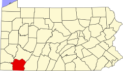
County Fayette
Townships Jefferson, Redstone
Area
[1]
  Total1.31 sq mi (3.41 km2)
  Land1.31 sq mi (3.41 km2)
  Water0.00 sq mi (0.00 km2)
Elevation
833 ft (254 m)
Population
 (2020) [2]
  Total489
  Density371.86/sq mi (143.61/km2)
Time zone UTC-5 (Eastern (EST))
  Summer (DST) UTC-4 (EDT)
ZIP code
15442
FIPS code 42-31592
GNIS feature ID1176245

Grindstone is an unincorporated community and census-designated place that is located in Jefferson and Redstone townships, in Fayette County, Pennsylvania, United States. The community was part of the Grindstone-Rowes Run CDP before it was split into two separate CDPs for the 2010 census. In 2010, the population was 498. [3]

Contents

The ZIP code for this community is 15442.

Geography

Grindstone is primarily located in southern Jefferson Township but extends south across Redstone Creek into the northern part of Redstone Township. It is bordered to the southeast by the community of Rowes Run.

Fayette City is 7.5 miles (12.1 km) to the north, and Uniontown, the Fayette County seat, is 12 miles (19 km) to the southeast. Brownsville is 4 miles (6 km) to the west.

Demographics

As of the 2020 U.S. Census, this town's population was 489. [4]

Related Research Articles

<span class="mw-page-title-main">Brownsville Township, Pennsylvania</span> Township in Pennsylvania, United States

Brownsville Township is a township in Fayette County, Pennsylvania, United States. The population was 536 at the 2020 census, a decline from the figure of 683 tabulated in 2010. It is served by the Brownsville School District.

<span class="mw-page-title-main">Grindstone-Rowes Run, Pennsylvania</span> Former CDP in Pennsylvania, United States

Grindstone-Rowes Run was a census-designated place (CDP) in Fayette County, Pennsylvania, United States.

<span class="mw-page-title-main">Hiller, Pennsylvania</span> Census-designated place in Pennsylvania, United States

Hiller is an unincorporated community and census-designated place in Fayette County, Pennsylvania, United States. As of the 2010 census, it had a population of 1,155, down from 1,234 at the 2000 census.

<span class="mw-page-title-main">Jefferson Township, Fayette County, Pennsylvania</span> Township in Pennsylvania, United States

Jefferson Township is a township in Fayette County, Pennsylvania, United States. The population was 2,007 at the 2020 census, a decline from the figure of 2,008 tabulated in 2010. It is named for former president Thomas Jefferson, and many of the township's streets are named after other U.S. presidents. Frazier School District serves the area.

<span class="mw-page-title-main">Leith-Hatfield, Pennsylvania</span> Census-designated place in Pennsylvania, United States

Leith-Hatfield is a census-designated place (CDP) in Fayette County, Pennsylvania, United States. The population was 2,546 at the 2010 census, down from 2,820 at the 2000 census. The twin villages of Leith and Hatfield are located in South Union Township.

<span class="mw-page-title-main">Oliver, Pennsylvania</span> Census-designated place in Pennsylvania, United States

Oliver is a census-designated place (CDP) in Fayette County, Pennsylvania, United States. The population was 2,535 at the 2010 census, down from 2,925 at the 2000 census. Oliver is located in North Union Township.

<span class="mw-page-title-main">Redstone Township, Pennsylvania</span> Township in Pennsylvania, United States

Redstone Township is a township in Fayette County, Pennsylvania, United States. The population was 5,077 at the 2020 census, a decline from the figure of 5,566 tabulated in 2010. The Brownsville Area School District serves the region.

<span class="mw-page-title-main">Republic, Pennsylvania</span> Census-designated place in Pennsylvania, United States

Republic is an unincorporated community and census-designated place (CDP) in Fayette County, Pennsylvania, United States. The population was 1,096 at the 2010 census, down from 1,396 at the 2000 census. The community is in Redstone Township.

Landisville is an unincorporated community and census-designated place (CDP) in East Hempfield Township, Lancaster County, Pennsylvania, United States. As of the 2010 census the population was 1,893. The community was once part of the Salunga-Landisville CDP, before splitting into two separate CDPs for the 2010 census, the other being Salunga.

<span class="mw-page-title-main">Farmington, Pennsylvania</span> Census-designated place in Pennsylvania, United States

Farmington is an unincorporated community and census-designated place in Wharton Township, Fayette County, Pennsylvania.

Hopeland is a small unincorporated hamlet and census-designated place (CDP) that is located in Lancaster County in the south of the U.S. state of Pennsylvania in the United States. The hamlet's ZIP code is 17533.

<span class="mw-page-title-main">Georgetown, Lancaster County, Pennsylvania</span> Census-designated place in Pennsylvania, United States

Georgetown is an unincorporated community and census-designated place (CDP) in Bart Township, Lancaster County, Pennsylvania, United States. As of the 2010 census, the population was 1,022. Georgetown has a post office for P.O. boxes that is called Bart and has the ZIP code of 17503. Otherwise, the CDP is divided into three ZIP code areas for more distant communities.

Lemont Furnace is an unincorporated community and census-designated place in North Union Township, Fayette County, Pennsylvania, United States. It is located 3 miles (5 km) northeast of the city of Uniontown and approximately 60 miles (97 km) southeast of Pittsburgh. The community is part of the Pittsburgh metropolitan area. At the 2010 census, the population of Lemont Furnace was 827.

Rowes Run is an unincorporated community and census-designated place in Redstone Township, Fayette County, Pennsylvania, United States. As of the 2010 census, its population was 564. The community was part of the Grindstone-Rowes Run CDP before it was split into two separate CDPs for the 2010 census.

Frizzleburg is an unincorporated community and census-designated place (CDP) in Lawrence County, Pennsylvania, United States. The population was 602 at the 2010 census.

New Salem is an unincorporated community and census-designated place located in Menallen Township, Fayette County, Pennsylvania, United States. It was formerly part of the New Salem-Buffington CDP, before it was split into two separate CDPs for the 2010 census. The population of New Salem was 579 as of the 2010 census.

Allison is an unincorporated community and census-designated place (CDP), which is located in Luzerne and Redstone townships in Fayette County, Pennsylvania, United States. It is situated 3 miles (5 km) south of the borough of Brownsville.

<span class="mw-page-title-main">Chalkhill, Pennsylvania</span> Census-designated place in Pennsylvania, United States

Chalk Hill is an unincorporated community and census-designated place in Wharton Township, Fayette County, Pennsylvania, United States. It is located along U.S. Route 40, approximately 8 miles (13 km) southeast of the city of Uniontown. As of the 2010 census, the population was 141.

Smock is an unincorporated community and census-designated place that is located in Franklin and Menallen townships in Fayette County, Pennsylvania, United States. Situated roughly halfway between the borough of Perryopolis and the city of Uniontown, it is part of the Pittsburgh metropolitan area.

Clay is an unincorporated community and census-designated place (CDP) in Clay Township, Lancaster County, Pennsylvania, United States. It is located along U.S. Route 322 between Brickerville and Ephrata. As of the 2010 census, the population was 1,559.

References

  1. "ArcGIS REST Services Directory". United States Census Bureau. Retrieved October 12, 2022.
  2. "Census Population API". United States Census Bureau. Retrieved October 12, 2022.
  3. "Geographic Identifiers: 2010 Census Summary File 1 (G001), Grindstone CDP, Pennsylvania". American FactFinder. U.S. Census Bureau. Archived from the original on February 13, 2020. Retrieved July 25, 2016.
  4. "Census of Population and Housing". Census.gov. Retrieved June 4, 2016.