Grindstone-Rowes Run, Pennsylvania

Last updated

Grindstone-Rowes Run
Former CDP
Map of Grindstone-Rowes Run, Fayette County, Pennsylvania Highlighted.png
Location of Grindstone-Rowes Run in Fayette County
Coordinates: 40°0′44″N79°49′15″W / 40.01222°N 79.82083°W / 40.01222; -79.82083
CountryUnited States
StatePennsylvania
County Fayette
Area
  Total2.2 sq mi (6 km2)
Population
 (2000)
  Total1,141
  Density520/sq mi (200/km2)
Time zone UTC-4 (EST)
  Summer (DST) UTC-5 (EDT)
Area code 724

Grindstone-Rowes Run was a census-designated place (CDP) in Fayette County, Pennsylvania, United States.

Contents

The population was 1,141 at the time of the 2000 census. For the 2010 census, the area was split into two CDPs, Grindstone and Rowes Run. The village of Grindstone is located in Jefferson Township, while Rowes Run is located in Redstone Township.

Geography

Grindstone-Rowes Run was located at 40°0′44″N79°49′15″W / 40.01222°N 79.82083°W / 40.01222; -79.82083 (40.012106, −79.820708). [1]

According to the United States Census Bureau, the CDP had a total area of 2.2 square miles (5.7 km2), all of it land.

Demographics

As of the 2000 census, [2] there were 1,141 people, 484 households, and 323 families residing in the CDP.

The population density was 531.7 inhabitants per square mile (205.3/km2). There were 530 housing units at an average density of 247.0 per square mile (95.4/km2).

The racial makeup of the CDP was 95.35% White, 3.07% African American, 0.09% Native American, 0.09% Pacific Islander, 0.79% from other races, and 0.61% from two or more races. Hispanic or Latino of any race were 0.53% of the population.

There were 484 households, out of which 24.6% had children under the age of eighteen living with them; 47.3% were married couples living together, 14.0% had a female householder with no husband present, and 33.1% were non-families. 30.0% of all households were made up of individuals, and 18.4% had someone living alone who was sixty-five years of age or older.

The average household size was 2.36 and the average family size was 2.92.

In the CDP, the population was spread out, with 20.9% under the age of eighteen, 7.5% from eighteen to twenty-four, 27.1% from twenty-five to forty-four 24.2% from forty-five to sixty-four, and 20.2% who were sixty-five years of age or older. The median age was forty-one years.

For every one hundred females, there were 92.1 males. For every one hundred females who were aged eighteen or older, there were 86.4 males.

The median income for a household in the CDP was $23,810, and the median income for a family was $30,625. Males had a median income of $27,045 compared with that of $17,500 for females.

The per capita income for the CDP was $12,486.

Roughly 15.8% of families and 21.6% of the population were living below the poverty line, including 39.1% of those who were under the age of eighteen and 11.1% of those who were aged sixty-five or older.

Related Research Articles

<span class="mw-page-title-main">West Elizabeth, Pennsylvania</span> Borough in Pennsylvania, United States

West Elizabeth is a borough in Allegheny County, Pennsylvania, United States. The population was 403 at the 2020 census.

Weissport East is a census-designated place (CDP) in Franklin Township in Carbon County, Pennsylvania. It is part of Northeastern Pennsylvania.

<span class="mw-page-title-main">Hiller, Pennsylvania</span> Census-designated place in Pennsylvania, United States

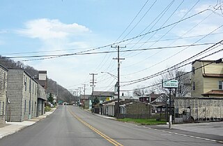
Hiller is an unincorporated community and census-designated place in Fayette County, Pennsylvania, United States. As of the 2010 census, it had a population of 1,155, down from 1,234 at the 2000 census.

<span class="mw-page-title-main">Newell, Pennsylvania</span> Borough in Pennsylvania, United States

Newell is a borough in Fayette County, Pennsylvania, United States. The population was 512 at the time of the 2020 census.

<span class="mw-page-title-main">Young Township, Indiana County, Pennsylvania</span> Township in Pennsylvania, United States

Young Township is a township that is located in Indiana County, Pennsylvania, United States. It was named after John Young, the first president judge of Indiana county.

<span class="mw-page-title-main">Mexico, Juniata County, Pennsylvania</span> Census-designated place in Pennsylvania, United States

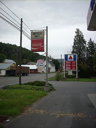
Mexico is an unincorporated community and census-designated place (CDP) in Walker Township, Juniata County, Pennsylvania, United States.

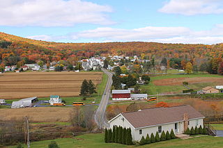
Highland Park is a census-designated place (CDP) in Mifflin County, Pennsylvania, United States. The population was 1,446 at the time of the 2000 census.

<span class="mw-page-title-main">Menno Township, Pennsylvania</span> Township in Pennsylvania, United States

Menno Township is a township in Mifflin County, Pennsylvania, United States. The population was 1,978 at the time of the 2020 census.

<span class="mw-page-title-main">Gilbertsville, Pennsylvania</span> Census-designated place in Pennsylvania, United States

Gilbertsville is a census-designated place (CDP) in Douglass Township in northwestern Montgomery County, Pennsylvania, United States. It is located at the junction of Routes 73 and 100. The population was 4,832 at the 2010 census, and the ZIP code is 19525. The name is also applied to an indeterminate adjacent section of New Hanover Township served by the Gilbertsville Post Office, and in fact the New Hanover Township offices are located in an area considered to be part of Gilbertsville. Boyertown Area School District covers the town of Gilbertsville. Gilbertsville is considered a exurb to the northwest of Philadelphia.

<span class="mw-page-title-main">Nuremberg, Pennsylvania</span> Census-designated place in Pennsylvania, United States

Nuremberg is a census-designated place (CDP) that is located in Schuylkill and Luzerne counties, Pennsylvania, United States. The population was 434 at the time of the 2010 census.

<span class="mw-page-title-main">Stockdale, Pennsylvania</span> Borough in Pennsylvania, United States

Stockdale is a borough that is located in Washington County, Pennsylvania, United States. The population was 424 at the time of the 2020 census.

<span class="mw-page-title-main">Adamsburg, Pennsylvania</span> Borough in Pennsylvania, United States

Adamsburg is a borough that is located in Westmoreland County, Pennsylvania, United States. The population was 144 at the time of the 2020 federal census.

Grapeville is a census-designated place (CDP) in Hempfield Township, Westmoreland County, Pennsylvania, United States. The population was 676 at the time of the 2000 census.

<span class="mw-page-title-main">Herminie, Pennsylvania</span>

Herminie is a census-designated place (CDP) in Sewickley Township, Westmoreland County, Pennsylvania, United States. The population was 856 at the 2000 census.

<span class="mw-page-title-main">Hunker, Pennsylvania</span> Borough in Pennsylvania, United States

Hunker is a borough which is located in Westmoreland County, Pennsylvania, United States. It has been part of the Pittsburgh metropolitan area since 1950.

<span class="mw-page-title-main">Manor, Pennsylvania</span> Borough in Pennsylvania, United States

Manor is a borough that is located in Westmoreland County, Pennsylvania, United States. The population was 3,585 at the time of the 2020 census.

<span class="mw-page-title-main">New Florence, Pennsylvania</span> Borough in Pennsylvania, United States

New Florence is a borough that is located in Westmoreland County, Pennsylvania, United States. The population was 689 as of the 2010 census, which is a decrease from the total of 784 that was recorded by the 2000 census.

<span class="mw-page-title-main">North Belle Vernon, Pennsylvania</span> Borough in Pennsylvania, United States

North Belle Vernon is a borough in Westmoreland County, Pennsylvania, United States. The population was 1,971 at the time of the 2010 census.

<span class="mw-page-title-main">North Irwin, Pennsylvania</span> Borough in Pennsylvania, United States

North Irwin is a borough in Westmoreland County, Pennsylvania, United States. The population was 846 at the time of the 2010 census.

<span class="mw-page-title-main">Mount Carmel, South Carolina</span> CDP in South Carolina, United States

Mt. Carmel is a census-designated place (CDP) in McCormick County, South Carolina, United States. The population was 237 at the 2000 census.

References

  1. "US Gazetteer files: 2010, 2000, and 1990". United States Census Bureau. February 12, 2011. Retrieved April 23, 2011.
  2. "U.S. Census website". United States Census Bureau . Retrieved January 31, 2008.