Republic, Pennsylvania

Last updated

Republic, Pennsylvania
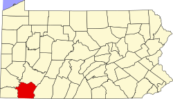
Map of Republic, Fayette County, Pennsylvania Highlighted.png
Location of Republic in Fayette County
Coordinates: 39°57′56″N79°52′41″W / 39.96556°N 79.87806°W / 39.96556; -79.87806
CountryUnited States
StatePennsylvania
County Fayette
Township Redstone
Area
[1]
  Total0.73 sq mi (1.88 km2)
  Land0.73 sq mi (1.88 km2)
  Water0.00 sq mi (0.00 km2)
Population
 (2020) [2]
  Total1,151
  Density1,583.22/sq mi (610.92/km2)
Time zone UTC-4 (EST)
  Summer (DST) UTC-5 (EDT)
ZIP code
15475 [3]
Area codes 724, 878
FIPS code42-64224

Republic is an unincorporated community and census-designated place (CDP) in Fayette County, Pennsylvania, United States. The population was 1,096 at the 2010 census, [4] down from 1,396 at the 2000 census. The community is in Redstone Township.

Contents

Geography

Republic is located in western Fayette County at 39°57′56″N79°52′41″W / 39.96556°N 79.87806°W / 39.96556; -79.87806 (39.965531, −79.878064), [5] on the western edge of Redstone Township. It is bordered to the west across Dunlap Creek by Luzerne Township.

Pennsylvania Route 166 passes through Republic, leading north 5 miles (8 km) to Brownsville and south 6 miles (10 km) to Edenborn. Pennsylvania Route 43, the Mon–Fayette Expressway, passes 3 miles (5 km) north of Republic, with access from Exit 22.

According to the United States Census Bureau, the CDP has a total area of 0.73 square miles (1.9 km2), all land. [4]

Demographics

Historical population
CensusPop.Note
2020 1,151
U.S. Decennial Census [6]

As of the 2000 census, [7] there were 1,396 people, 614 households, and 359 families residing in the CDP. The population density was 1,887.4 inhabitants per square mile (728.7/km2). There were 714 housing units at an average density of 965.3 per square mile (372.7/km2). The racial makeup of the CDP was 90.47% White, 7.02% African American, 0.29% Native American, 0.36% from other races, and 1.86% from two or more races. Hispanic or Latino of any race were 0.43% of the population.

There were 614 households, out of which 24.8% had children under the age of 18 living with them, 38.9% were married couples living together, 15.0% had a female householder with no husband present, and 41.5% were non-families. 37.6% of all households were made up of individuals, and 22.6% had someone living alone who was 65 years of age or older. The average household size was 2.27 and the average family size was 3.03.

In the CDP, the population was spread out, with 23.4% under the age of 18, 7.8% from 18 to 24, 25.6% from 25 to 44, 21.7% from 45 to 64, and 21.5% who were 65 years of age or older. The median age was 40 years. For every 100 females, there were 82.7 males. For every 100 females age 18 and over, there were 83.0 males.

The median income for a household in the CDP was $20,598, and the median income for a family was $26,411. Males had a median income of $37,813 versus $19,653 for females. The per capita income for the CDP was $14,201. About 20.4% of families and 22.9% of the population were below the poverty line, including 28.4% of those under age 18 and 14.2% of those age 65 or over.

Notable person

Related Research Articles

<span class="mw-page-title-main">Brownsville Township, Pennsylvania</span> Township in Pennsylvania, United States

Brownsville Township is a township in Fayette County, Pennsylvania, United States. The population was 536 at the 2020 census, a decline from the figure of 683 tabulated in 2010. It is served by the Brownsville School District.

<span class="mw-page-title-main">Connellsville Township, Pennsylvania</span> Township in Pennsylvania, United States

Connellsville Township is a township in Fayette County, Pennsylvania, United States. The population was 2,073 at the 2020 census, a decline from the figure of 2,391 tabulated in 2010.

<span class="mw-page-title-main">East Uniontown, Pennsylvania</span> Census-designated place in Pennsylvania, United States

East Uniontown is a census-designated place (CDP) in Fayette County, Pennsylvania, United States. The population was 2,419 at the 2010 census, down from 2,760 at the 2000 census.

<span class="mw-page-title-main">Franklin Township, Fayette County, Pennsylvania</span> Township in Pennsylvania, United States

Franklin Township is a township in Fayette County, Pennsylvania, United States. The population was 2,380 at the 2020 census, a decline from the figure of 2,528 tabulated in 2010. The township is served by the Uniontown Area School District.

<span class="mw-page-title-main">Georges Township, Pennsylvania</span> Township in Pennsylvania, United States

Georges Township is a township in Fayette County, Pennsylvania, United States. The population was 6,346 at the 2020 census, a decline from the figure of 6,612 tabulated in 2010. It is served by the Albert Gallatin Area School District.

<span class="mw-page-title-main">German Township, Fayette County, Pennsylvania</span> Township in Pennsylvania, United States

German Township is a township in Fayette County, Pennsylvania, United States. The population was 4,672 at the 2020 census, a decline from the figure of 5,097 tabulated in 2010. McClellandtown is the township's largest village. The Albert Gallatin Area School District serves the region.

<span class="mw-page-title-main">Grindstone-Rowes Run, Pennsylvania</span> Former CDP in Pennsylvania, United States

Grindstone-Rowes Run was a census-designated place (CDP) in Fayette County, Pennsylvania, United States.

<span class="mw-page-title-main">Hiller, Pennsylvania</span> Census-designated place in Pennsylvania, United States

Hiller is an unincorporated community and census-designated place in Fayette County, Pennsylvania, United States. As of the 2010 census, it had a population of 1,155, down from 1,234 at the 2000 census.

<span class="mw-page-title-main">Hopwood, Pennsylvania</span> Census-designated place in Pennsylvania, United States

Hopwood is a census-designated place (CDP) in Fayette County, Pennsylvania, United States. The population was 2,090 at the 2010 census, up from 2,006 at the 2000 census. It is located in North Union and South Union townships. The village was named after John Hopwood.

<span class="mw-page-title-main">Jefferson Township, Fayette County, Pennsylvania</span> Township in Pennsylvania, United States

Jefferson Township is a township in Fayette County, Pennsylvania, United States. The population was 2,007 at the 2020 census, a decline from the figure of 2,008 tabulated in 2010. It is named for former president Thomas Jefferson, and many of the township's streets are named after other U.S. presidents. Frazier School District serves the area.

<span class="mw-page-title-main">Leith-Hatfield, Pennsylvania</span> Census-designated place in Pennsylvania, United States

Leith-Hatfield is a census-designated place (CDP) in Fayette County, Pennsylvania, United States. The population was 2,546 at the 2010 census, down from 2,820 at the 2000 census. The twin villages of Leith and Hatfield are located in South Union Township.

<span class="mw-page-title-main">Luzerne Township, Pennsylvania</span> Township in Pennsylvania, United States

Luzerne Township is a township in Fayette County, Pennsylvania, United States. The population was 5,585 at the 2020 census, down from 5,965 at the 2010 census.

<span class="mw-page-title-main">New Salem-Buffington, Pennsylvania</span> Former CDP in Pennsylvania, United States

New Salem-Buffington was a census-designated place (CDP) in Fayette County, Pennsylvania, United States, and part of the Pittsburgh Metro Area. The population was 808 at the 2000 census. For the 2010 census the area was split into two CDPs, New Salem and Buffington. Both communities are located in Menallen Township.

<span class="mw-page-title-main">North Union Township, Fayette County, Pennsylvania</span> Township in Pennsylvania, United States

North Union Township is a township in Fayette County, Pennsylvania, United States. The population was 11,829 at the 2020 census, a decline from the figure of 12,728 tabulated in 2010. The Laurel Highlands School District serves the township.

<span class="mw-page-title-main">Oliver, Pennsylvania</span> Census-designated place in Pennsylvania, United States

Oliver is a census-designated place (CDP) in Fayette County, Pennsylvania, United States. The population was 2,535 at the 2010 census, down from 2,925 at the 2000 census. Oliver is located in North Union Township.

<span class="mw-page-title-main">Redstone Township, Pennsylvania</span> Township in Pennsylvania, United States

Redstone Township is a township in Fayette County, Pennsylvania, United States. The population was 5,077 at the 2020 census, a decline from the figure of 5,566 tabulated in 2010. The Brownsville Area School District serves the region.

<span class="mw-page-title-main">South Union Township, Pennsylvania</span> Township in Pennsylvania, United States

South Union Township is a township in Fayette County, Pennsylvania, United States. The population was 10,897 at the 2020 census, an increase over the figure of 10,681 tabulated in 2010.

<span class="mw-page-title-main">Stewart Township, Pennsylvania</span> Township in Pennsylvania, United States

Stewart Township is a township in Fayette County, Pennsylvania, United States. It is part of the Pittsburgh metropolitan area. The population was 623 at the 2020 census.

<span class="mw-page-title-main">McAlisterville, Pennsylvania</span> Census-designated place in Pennsylvania, United States

McAlisterville is an unincorporated community and census-designated place (CDP) in Fayette Township, Juniata County, Pennsylvania, United States. The population was 971 at the 2010 census.

Lynnwood-Pricedale is a census-designated place (CDP) in Fayette and Westmoreland counties in the Pennsylvania. The population was 2,031 at the 2010 census, down from 2,168 at the 2000 census. The community of Lynwood is located in Fayette County's Washington Township, while Pricedale is part of Westmoreland County's Rostraver Township.

References

  1. "ArcGIS REST Services Directory". United States Census Bureau. Retrieved August 8, 2023.
  2. "Census Population API". United States Census Bureau. Retrieved August 8, 2023.
  3. "Republic PA ZIP Code". zipdatamaps.com. 2023. Retrieved May 13, 2023.
  4. 1 2 "Geographic Identifiers: 2010 Census Summary File 1 (G001), Republic CDP, Pennsylvania". American FactFinder. U.S. Census Bureau. Archived from the original on February 13, 2020. Retrieved July 27, 2016.
  5. "US Gazetteer files: 2010, 2000, and 1990". United States Census Bureau. February 12, 2011. Retrieved April 23, 2011.
  6. "Census of Population and Housing". Census.gov. Retrieved June 4, 2016.
  7. "U.S. Census website". United States Census Bureau . Retrieved January 31, 2008.