Westmoreland City, Pennsylvania

Last updated

Westmoreland City
USA Pennsylvania location map.svg
Red pog.svg
Westmoreland City
Location within the state of Pennsylvania
Coordinates: 40°19′52″N79°40′37″W / 40.33111°N 79.67694°W / 40.33111; -79.67694
Country United States
State Pennsylvania
County Westmoreland
Township North Huntingdon Township
Elevation
984 ft (300 m)
Time zone UTC-5 (Eastern (EST))
  Summer (DST) UTC-4 (EDT)
ZIP codes
15692
GNIS feature ID1191174 [1]

Westmoreland City is an unincorporated community located within North Huntingdon Township, Westmoreland County, Pennsylvania, United States.

Related Research Articles

<span class="mw-page-title-main">Latrobe, Pennsylvania</span> City in Pennsylvania, United States

Latrobe is a city in Westmoreland County, Pennsylvania, United States. The population was 8,060 as of the 2020 census. A part of the Pittsburgh metropolitan area, it is located near Pennsylvania's scenic Chestnut Ridge. Latrobe was incorporated as a borough in 1854, and as a city in 1999. The current mayor is Eric J. Bartels.
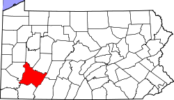
<span class="mw-page-title-main">Westmoreland County, Pennsylvania</span> County in Pennsylvania, United States

Westmoreland County is a county in the Commonwealth of Pennsylvania, United States, located in the Pittsburgh Metropolitan Statistical Area. As of the 2020 census, the population was 354,663. The county seat is Greensburg and the most populous community is Hempfield Township. It is named after Westmorland, a historic county of England.

Westmoreland or Westmorland may refer to:

<span class="mw-page-title-main">Derry Township, Westmoreland County, Pennsylvania</span> Township in Pennsylvania, United States

Derry Township is a township in Westmoreland County, Pennsylvania, United States. It surrounds the borough of Derry, which is a separate municipality. As of the 2020 census, the township population was 13,631.

<span class="mw-page-title-main">Greensburg, Pennsylvania</span> City in Pennsylvania, United States

Greensburg is a city in and the county seat of Westmoreland County, Pennsylvania, United States. The population was 14,976 at the 2020 census. Located 30 miles (48 km) southeast of Pittsburgh, Greensburg is a part of the Pittsburgh metropolitan area. The city lies within the Laurel Highlands and the ecoregion of the Western Allegheny Plateau. The city is named after Nathanael Greene, a major general of the Continental Army in the American Revolutionary War.

<span class="mw-page-title-main">Hempfield Township, Westmoreland County, Pennsylvania</span> Township in Pennsylvania, United States

Hempfield Township is a township in Westmoreland County, Pennsylvania, United States. The population was 41,585 at the 2020 census, making it the largest suburb in the Pittsburgh Metropolitan Area by population. Its name is derived from Hempfield in Lancaster County, which was formed in 1729 and is named after the hemp fields in the area.

<span class="mw-page-title-main">Penn Township, Westmoreland County, Pennsylvania</span> Township in Pennsylvania, United States

Penn Township is a township in Westmoreland County, Pennsylvania, United States.

<span class="mw-page-title-main">Unity Township, Pennsylvania</span> Township in Pennsylvania, United States

Unity Township is a township in Westmoreland County, Pennsylvania, United States. The population was 21,724 at the 2020 census, a decline of approximately 4% compared to the 2010 census.

<span class="mw-page-title-main">Laurel Highlands</span> Region in Pennsylvania

The Laurel Highlands is a region in southwestern Pennsylvania made up of Fayette County, Somerset County, and Westmoreland County. It has a population of about 600,000 people.

Hannastown is an unincorporated community and important historical and archaeological site located in Hempfield Township, Westmoreland County, Pennsylvania, United States. Although the village is not tracked by the Census Bureau, it has been assigned the ZIP code 15635.

<span class="mw-page-title-main">Greater Pittsburgh</span> Region in the U.S. State of Pennsylvania

Greater Pittsburgh is the metropolitan area surrounding the city of Pittsburgh in Western Pennsylvania, United States. The region includes Allegheny County, Pittsburgh's urban core county and economic hub, and seven adjacent Pennsylvania counties: Armstrong, Beaver, Butler, Fayette, Lawrence, Washington, and Westmoreland in Western Pennsylvania, which constitutes the Pittsburgh, PA Metropolitan Statistical Area MSA as defined by the U.S. Census Bureau.

<span class="mw-page-title-main">National Register of Historic Places listings in Pennsylvania</span>

This is a list of properties and districts listed on the National Register of Historic Places in Pennsylvania. As of 2015, there are over 3,000 listed sites in Pennsylvania. All 67 counties in Pennsylvania have listings on the National Register.

<span class="mw-page-title-main">Pennsylvania's 12th congressional district</span> U.S. House district for Pennsylvania

Pennsylvania's 12th congressional district is located in southwestern Pennsylvania, including Pittsburgh and much of Allegheny County, as well as some of Westmoreland County. Since January 3, 2023, it has been represented by Summer Lee.

<span class="mw-page-title-main">Laurel Summit State Park</span>

Laurel Summit State Park is a 6-acre (2.4 ha) Pennsylvania state park in Cook Township, Westmoreland County, Pennsylvania in the United States. It is also a picnic area with a scenic view of Linn Run on the summit of Laurel Mountain. The temperatures at Laurel Summit State Park are generally several degrees cooler than the surrounding towns in the valleys. The elevation of the park is 2,739 feet (835 m) above sea level.

<span class="mw-page-title-main">Pennsylvania's 18th congressional district</span> U.S. House district for Pennsylvania

Pennsylvania's 18th congressional district was a district including the city of Pittsburgh and parts of surrounding suburbs. A variety of working class and majority black suburbs located to the east of the city were included, such as McKeesport and Wilkinsburg. Also a major part of the district was a number of middle class suburbs that have historic Democratic roots, such as Pleasant Hills and Penn Hills. The district became obsolete following the 2020 United States census. It was largely replaced by Pennsylvania's 12th congressional district.

The Westmoreland County coal strike of 1910–1911, or the Westmoreland coal miners' strike, was a strike by coal miners represented by the United Mine Workers of America. The strike is also known as the Slovak Strike because about 70 percent of the miners were Slovak immigrants. It began in Westmoreland County, Pennsylvania, on March 9, 1910, and ended on July 1, 1911. At its height, the strike encompassed 65 mines and 15,000 coal miners. Sixteen people were killed during the strike, nearly all of them striking miners or members of their families. The strike ended in defeat for the union.

<span class="mw-page-title-main">Pennsylvania House of Representatives, District 60</span> American legislative district

The 60th Pennsylvania House of Representatives District is located in western Pennsylvania has been represented by Abby Major since 2021.

<span class="mw-page-title-main">National Register of Historic Places listings in Westmoreland County, Pennsylvania</span>

This is a list of the National Register of Historic Places listings in Westmoreland County, Pennsylvania.

<span class="mw-page-title-main">Five Star Trail</span>

References