
Westmoreland County is a county located in the U.S. state of Pennsylvania. At the 2010 census, the population was 365,169. The county seat is Greensburg. Formed from, successively, Lancaster, Northumberland, and later Bedford Counties, Westmoreland County was founded on February 26, 1773, and was the first county in the colony of Pennsylvania whose entire territorial boundary was located west of the Allegheny Mountains. Westmoreland County originally included the present-day counties of Fayette, Washington, Greene, and parts of Beaver, Allegheny, Indiana, and Armstrong counties. It is named after Westmorland, a historic county of England.

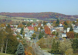
Derry is a borough in Westmoreland County in the Commonwealth of Pennsylvania, 45 miles (72 km) east of Pittsburgh. The Borough of Derry, consisting of the town area, should not be confused with Derry Township, which is a separate municipality surrounding the borough. The population was 2,688 at the 2010 census.
Ligonier is a borough in Westmoreland County, Pennsylvania, United States. The population was 1,573 at the 2010 census. Ligonier was settled in the 1760s. The borough is well known for nearby Idlewild Park, one of the oldest amusement parks in the country; and nearby Seven Springs Mountain Resort. Another tourist attraction is Fort Ligonier Days, a parade and craft market that takes place every fall over the course of three days, and the Ligonier Country Market in the summer months. Ligonier is part of the Pittsburgh Metropolitan Statistical Area.

Youngstown is a borough in Westmoreland County, Pennsylvania, United States. Youngstown was incorporated on 2 April 1831. The population was 400 at the 2000 census.

Westmoreland County Community College was founded in 1970 and is located in Youngwood, Pennsylvania, USA.

The Laurel Highlands is a region in southwestern Pennsylvania made up of Cambria County, Fayette County, Somerset County and Westmoreland County. It has a population of about 600,000 people.

The Greater Pittsburgh Region is a populous region in the United States which is named for its largest city and economic center, Pittsburgh, Pennsylvania. There are several official and unofficial boundary definitions which may be used to describe this region. In the most restrictive definition, the region encompasses Pittsburgh's urban core county, Allegheny, and six nearby Pennsylvania counties.
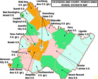
The Westmoreland Intermediate Unit, a regional educational service agency near Pittsburgh, provides leadership and support in curriculum, finance, management, special education, and technology through research, consultation, collaboration, communication, training, and education to students, schools and communities. The WIU represents the following school districts: Belle Vernon Area, Burrell, Derry Area, Franklin Regional, Greater Latrobe, Greensburg Salem, Hempfield Area, Jeannette City, Kiski Area, Ligonier Valley, Mount Pleasant Area, Monessen City, New Kensington-Arnold, Norwin, Penn-Trafford, Southmoreland, and Yough.
The Jeannette City School District is a small urban school district in Southwestern Pennsylvania. It is located in Westmoreland County and is surrounded by the Penn-Trafford and Hempfield Area School Districts. The district consists of three schools, with the elementary and middle schools located in the same building. They are also home to the 2006 and 2007 WPIAL AA Champions and 2007 PIAA AA State Champion, Jeannette Jayhawks.

Pennsylvania's 12th congressional district is located in the north central and northeastern parts of Pennsylvania, including the Northern Tier region, parts of the Susquehanna Valley, and part of Happy Valley including State College. It has been represented by Fred Keller since May 21, 2019, who won a special election to fill the vacancy caused by the resignation of former representative Tom Marino.
The Ligonier Valley Railroad connected the communities of Latrobe and Ligonier, Pennsylvania, approximately 10 miles (16 km) apart, between 1877 and 1952. For much of its length, the railroad ran parallel to Loyalhanna Creek in a scenic mountain gorge. In addition to the Latrobe-Ligonier line, there was an extension to the coal mining communities of Wilpen and Fort Palmer to the north of Ligonier, as well as several shorter spurs serving coal mines.
The Westmoreland County Transit Authority (WCTA) is the operator of mass transportation in Westmoreland County, Pennsylvania. Using 35 buses, a total of 18 routes are operated, the majority of which serve the urbanized corridor that makes up the western portion of the county. Bus routes in this area are designed to provide access for suburban commuters to Downtown Pittsburgh, as well as transportation for both workers and shoppers to the large suburbs of Greensburg and New Kensington, Pennsylvania the most prominent entities in the county's boundaries. Rural eastern bus routes allow for commutes to Greensburg and also provide service to the city of Johnstown in neighboring Cambria County.
Ligonier Valley School District is a public school district in Westmoreland County, Pennsylvania. The boroughs of Ligonier, Laurel Mountain, Bolivar, Seward, New Florence, as well as the townships of Cook, St. Clair, Ligonier, and Fairfield are within district boundaries. In 2017, The Ligonier Valley Rams Varsity Football Team won their Second District VI Championship in football.
Laurel Valley Middle and High School was an American public high school, located near New Florence, Pennsylvania in Westmoreland County. The school served approximately 300 students who lived in the following municipalities:
Mount Pleasant Area Junior/Senior High School is a public high school in Mount Pleasant Township, Westmoreland County, Pennsylvania. It is part of the Mount Pleasant Area School District. It enrolls 1200 students in grades 7-12. It is located off Pennsylvania Route 981. The high school was opened in 1964, and the junior high was added in 1975.
Rector is a small unincorporated community in Ligonier Township, Westmoreland County, Pennsylvania, United States. Nearby attractions are Linn Run State Park and Flat Rock. As of 2000, the population of Rector was 600. Rector is composed of 26.4 miles2.

